- Home
- :
- All Communities
- :
- Products
- :
- ArcGIS Pro
- :
- ArcGIS Pro Questions
- :
- Re: ArcGIS Pro 2.0.0 WFS - Unsupported data type
- Subscribe to RSS Feed
- Mark Topic as New
- Mark Topic as Read
- Float this Topic for Current User
- Bookmark
- Subscribe
- Mute
- Printer Friendly Page
ArcGIS Pro 2.0.0 WFS - Unsupported data type
- Mark as New
- Bookmark
- Subscribe
- Mute
- Subscribe to RSS Feed
- Permalink
- Report Inappropriate Content
I have now tried to connect to many different WFS services and I have still not succeeded (All of them works in QGis).
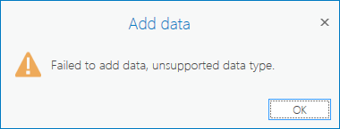
I can create the connection and all the layers show in Catalog, but when I try to add to a map I get this message every time..
Where can I find the real error message?
Why can't I edit the connection parameters, I have to create a new connection every time?
If I use MODE = COMPATIBLE I don't get the error, but the features won't draw and polygon features seems to be recognized as points?
Does anyone know a real guide - better than the one from help?
- Mark as New
- Bookmark
- Subscribe
- Mute
- Subscribe to RSS Feed
- Permalink
- Report Inappropriate Content
I assume you are talking about these WFS...
The warnings about what still isn't implemented is at the bottom of that page and the processing toolbar links are within the same area.
You didn't indicate beyond an 'add' what else you have looked at.
- Mark as New
- Bookmark
- Subscribe
- Mute
- Subscribe to RSS Feed
- Permalink
- Report Inappropriate Content
Yes, I am talking about adding a WFS connection as described in your link. Yes, it's for read only. Yes. it is a standard OGC WFS 1.1.0 service using gml3. Yes it works in QGIS, in Openlayers and can be added as a layer in AGOL... why can't I add it to my ArcGIS Pro 2.0.0 map - and why can't I get a better error description?
\Morten
- Mark as New
- Bookmark
- Subscribe
- Mute
- Subscribe to RSS Feed
- Permalink
- Report Inappropriate Content
Well it looks like you have covered all the question bases. As for an answer, especially about the error description, it would be best to contact Tech Support and file a support case. A recent blog on helpful steps in Contacting Tech support is provided here. Sorry, I am not part of tech support, and I suspect I can't be of further assistance.
- Mark as New
- Bookmark
- Subscribe
- Mute
- Subscribe to RSS Feed
- Permalink
- Report Inappropriate Content
Almost forgot the almost all-encompassing Supported Data types link
- Mark as New
- Bookmark
- Subscribe
- Mute
- Subscribe to RSS Feed
- Permalink
- Report Inappropriate Content
Hi, I have this same problem. I can create the connection and all the layers show in Catalog and I can add layer in AGOL but why can't I do the same thing in ArcGIS Pro (2.2.0)?
Did you get any answer from Tech Support?
I would like to know is there any help for this problem...
- Mark as New
- Bookmark
- Subscribe
- Mute
- Subscribe to RSS Feed
- Permalink
- Report Inappropriate Content
BUG-000106864: ArcGIS Pro 2.0 fails to display Web Feature Service ..
BUG-000116190: Unable to connect to a folder or add data from a fol..
now appear with the ….unsupported data type phrase