- Home
- :
- All Communities
- :
- Products
- :
- ArcGIS Pro
- :
- ArcGIS Pro Ideas
- :
- View GeoPDF Files in ArcMap
- Subscribe to RSS Feed
- Mark as New
- Mark as Read
- Bookmark
- Follow this Idea
- Printer Friendly Page
- Report Inappropriate Content
- Mark as New
- Bookmark
- Subscribe
- Mute
- Subscribe to RSS Feed
- Permalink
- Report Inappropriate Content
GeoPDF formatted data represents a large and growing source of information. The US Geological Survey is creating all new US Topo products in GeoPDF format and the National Geospatial Intelligence Agency is releasing scanned map products in GeoPDF format.
It would be a great help if ArcMap would be able to display these GeoPDF products ... at least as a background map ... if not exploit their content further.
- « Previous
-
- 1
- …
- 10
- 11
- 12
- Next »
- Mark as Read
- Mark as New
- Bookmark
- Permalink
- Report Inappropriate Content
Hi Betty Alex,
I also work in cultural resources for the NPS. What park do you work for? I followed you on your GeoNet page, and would just send you a private message there. "Follow" me and we can correspond via cultural resources and GIS in the NPS.
- Mark as Read
- Mark as New
- Bookmark
- Permalink
- Report Inappropriate Content
Agree. What is taking so long for this to work for all of us? Seems like a no brainer.
- Mark as Read
- Mark as New
- Bookmark
- Permalink
- Report Inappropriate Content
Right now the only way to bring in a GeoPDF back into ArcMap is with the TerraGo toolbar for ArcGIS which you have to pay for. Not too expensive but not cheap if you are an independent consultant
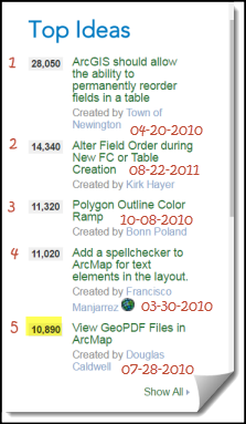
I have pretty much given up on ESRI and ArcGIS Ideas. Anything we say and all the votes that we get do not mean squat to the developers. Just look at the ideas with the most votes and comments. Nothing!! This one is over 6 years old and will be 7 years old on 28th of July. As of today, 1,089 GIS users have said to ESRI developers that they want this enhancement. It is number 5 on the list of Top Ideas for ArcGIS Ideas of all time and still nothing.
Global Mapper has the ability to load GeoPDFs why can't ArcGIS?
Link:
http://www.globalmapperforum.com/features/geopdf-support/
If this is never going to happen, they can at least defer the idea and shoot it down instead of stringing us along for 6 years.
I throw my hands up in the air and have given up with these people.
- Mark as Read
- Mark as New
- Bookmark
- Permalink
- Report Inappropriate Content
OK - after years of waiting for Esri to provide a solution I, and 2 crazy colleageus, got all of the USGS topos as of last December and we ripped all of them out into a GeoTIFF format. These are freely available through the USGS Hazards Data Discovery System (HDDS). If you want step-by-step instructions on how to downlaod these contact me. I have a tip sheet that is easy to use. lpeltzlewis@fs.fed.us
- Mark as Read
- Mark as New
- Bookmark
- Permalink
- Report Inappropriate Content
This has been reviewed, but, has it been acted on?
- Mark as Read
- Mark as New
- Bookmark
- Permalink
- Report Inappropriate Content
Thank you Shawn Paulson for the link to Global Mapper software which can accomplish this task:
Global Mapper has the ability to load GeoPDFs why can't ArcGIS?
Link:
- Mark as Read
- Mark as New
- Bookmark
- Permalink
- Report Inappropriate Content
use gdalbuildvrt create a VRT and drag in VRT into ArcMap. Global Mapper does an amazing job reading geopdf's and even extracting Vector data from them. GPKG is the new open standard and data should be distributed in OGC GeoPackage format with Layer_Styles table or SLD's. Viewable in Desktop GIS, Mobile and Web GIS.
- Mark as Read
- Mark as New
- Bookmark
- Permalink
- Report Inappropriate Content
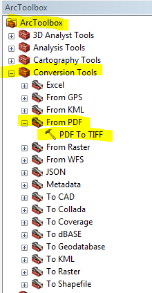
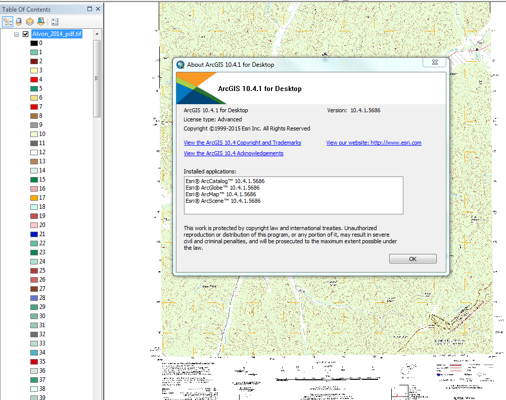
I just tried converting a USGS geopdf to a geotif and adding it to Arc, and it worked, at least for my version and license type (please see the two images below):
ArcToolbox > Conversion Tools > From PDF > PDF To TIFF:
My version and license type:
- Mark as Read
- Mark as New
- Bookmark
- Permalink
- Report Inappropriate Content
Thanks for pointing out the PDF to TIFF tool in Arc. When was this tool added? Running 10.5 and tool works with some caveats.
GeoPDF downloaded from the national map site converts to GeoTIFF, but first attempt (using all the default settings of the tool) did not convert to a map that looked like the original. There are quite a few settings in the tool dialog box and I found that to get a matching GeoTIFF from the GeoPDF you need to select in the Color Mode window RGB_Palette, which is not the default setting.
The default resolution of 250 dpi is OK, but a higher resolution will produce a better looking map and you would certainly want to use a higher resolution if you plan to only use a section of a quad.
Have used Blue Marble Global Mapper for years to convert GeoPDFs from the National Map site to GeoTIFFs for use in Arc. Glad to see that Arc has finally added this conversion capability.
One additional thing. For some reason you need to add .tif to the end of the file name of the TIFF you are creating for the tool to run. Without the .tif, a warning box that the file name is invalid will pop up.
Dave
- Mark as Read
- Mark as New
- Bookmark
- Permalink
- Report Inappropriate Content
Thanks Dave, I should have mentioned to choose your options wisely. The RGB_Palette produces indexed colors that you can drop out as needed, I set my dpi to 400, and I used the UTM option as well. ... and yes, it is not obvious you have to add .tif to the file name. It's a little clunky, but it works after you figure out the tweaks (like everything else in Arc). We don't all have Global Mapper. Bottom line: users need to play around with the settings and see what works for them. As to when it was added.... who knows? I just happened upon it one day and forgot I was subscribed to this thread until some comments popped up today. I was running 10.2 before I upgraded to 10.4, so I am guessing it was added in there somewhere.
You must be a registered user to add a comment. If you've already registered, sign in. Otherwise, register and sign in.