- Home
- :
- All Communities
- :
- Products
- :
- ArcGIS Pro
- :
- ArcGIS Pro Ideas
- :
- Export GeoTIFF - Proposals
- Subscribe to RSS Feed
- Mark as New
- Mark as Read
- Bookmark
- Follow this Idea
- Printer Friendly Page
- Report Inappropriate Content
- Mark as New
- Bookmark
- Subscribe
- Mute
- Subscribe to RSS Feed
- Permalink
- Report Inappropriate Content
There are several proposals to improve the quality of exported GeoTIFFs:
1. GeoTIFF can only be exported in RGB. CMYK should be an additional option which would be important for printing maps.
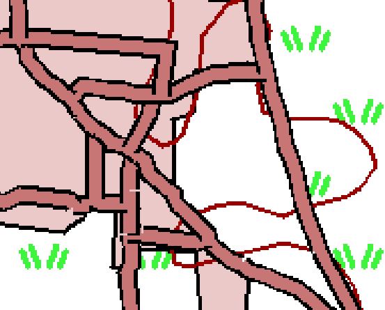
2. GeoTIFFs shouldn't have pixel inside the map with the color value 0,0,0, because this value will mostly be used as NoData-Value in other software products to remove black wedges (attachment 1). If you set the NoData - Value 0,0,0 black contours of the road will be also removed (attachment 2).
3. There are no functions for smoothing black contours which are part of the road in ArcGIS.
- Mark as Read
- Mark as New
- Bookmark
- Permalink
- Report Inappropriate Content
There is a workaround in ArcGIS to export the GeoTIFF with the correct pixel size. You will need the ArcPy-Tool. This workaround doesn't work in ArcGIS Pro. ESRI plans to improve ArcGIS Pro and the following enhancement request were created:
ENH-000112121: Request for the functionality to export the map as an image file (E.g. GeoTIFF) with the desired Pixel Size and Scale
In the future we will have the possibility to export GeoTIFF from ArcGIS Pro with the correct scale, pixel size and resolution. We are looking forward to see the new settings of the GeoTIFF-Export in the future which are standard in some other software solutions (e.g. Global mapper).
- Mark as Read
- Mark as New
- Bookmark
- Permalink
- Report Inappropriate Content
The smoothing in ArcGIS is possible with the antialyzing - functions under the NVIDIA system settings. The disadvantage is the file size which will be bigger then. In ArcGIS Pro you will have settings for the antialyzing:
https://pro.arcgis.com/de/pro-app/help/mapping/map-authoring/display-options.htm
You must be a registered user to add a comment. If you've already registered, sign in. Otherwise, register and sign in.