- Home
- :
- All Communities
- :
- Products
- :
- ArcGIS Parcel Fabric
- :
- ArcGIS Parcel Fabric Questions
- :
- Re: ArcgisPro Parcel Fabric - Parcel Corners Numbe...
- Subscribe to RSS Feed
- Mark Topic as New
- Mark Topic as Read
- Float this Topic for Current User
- Bookmark
- Subscribe
- Mute
- Printer Friendly Page
ArcgisPro Parcel Fabric - Parcel Corners Numbering & Parcel Lines
- Mark as New
- Bookmark
- Subscribe
- Mute
- Subscribe to RSS Feed
- Permalink
- Report Inappropriate Content
Hello, I am working on ArcGIS pro 2.8, and I am trying to create a parcel fabric for my surveyed parcels. My problem is about for Parcel corners and parcel lines. First issue is, how can I re-number parcel corners for each parcel? There should be a relation between parcel corner and related parcel for sure. But I couldn't figure out, I need to read/watch more. And second issue is about Parcel lines. I have parcel line segments length, its ok but there is no start and end parcel corner names in the attribute field. I mean when we create a parcel fabric lines in ArcMap , there is a field like FROM / TO and this field includes start parcel corner name and end name. So I need a source to figure out those issues. Thanks.
- Mark as New
- Bookmark
- Subscribe
- Mute
- Subscribe to RSS Feed
- Permalink
- Report Inappropriate Content
Mustafa,
Welcome to the new Parcel Fabric. I suggest brushing up on the structure some here:
https://pro.arcgis.com/en/pro-app/latest/help/data/parcel-editing/createaparcelfabric.htm
Down a little ways is the Parcel Fabric Data Model and below that is the description of the various components.
In summary, the lines do not have an association with the points like before (To/From ID's). Also, parcels do not have their own lines. The lines belong to the record that creates them and adjoining lots from the same record will share a line. No more duplicate lines, at least from the same Record. Points, like before, do not belong to a parcel, but are shared amongst all lines. A point (parcel/lot corner) just represents where a measured (Record) line ends and can be shared between many parcels, even between different parcel types. They are created and associated with a Record though. You can extend the attribute fields if you wish to maintain additional data on them. That goes for Records, Lines and Parcels too.
Hope this helps.
Dennis
OC Landbase
- Mark as New
- Bookmark
- Subscribe
- Mute
- Subscribe to RSS Feed
- Permalink
- Report Inappropriate Content
Thanks Dennis for great answer, really helpful.
- Mark as New
- Bookmark
- Subscribe
- Mute
- Subscribe to RSS Feed
- Permalink
- Report Inappropriate Content
Could you please share why you want to number the parcel corners?
Are those permanent numbers or temporary numbers that are used for producing a layout like the example below?
Does the order of the numbering matter or could it be random?
If this is for layout, do you plan to have multiple parcels or one parcel at a time?
If you have an example of what you are trying to achieve it would be great if you can share it and any information (your organization, is this part of a legislated standard, etc.)

- Mark as New
- Bookmark
- Subscribe
- Mute
- Subscribe to RSS Feed
- Permalink
- Report Inappropriate Content
Thanks Amir, I will try to summarize our studies. Actually lets start from your notes,
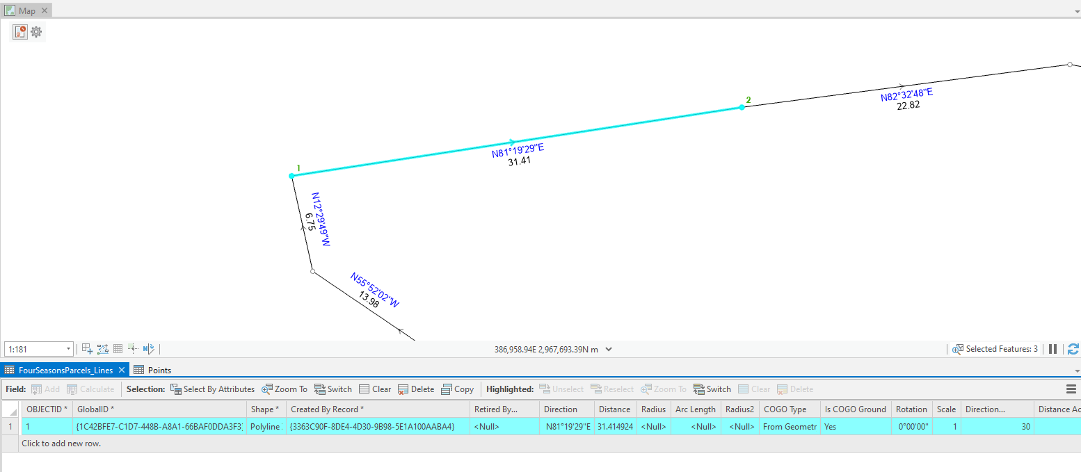
Could you please share why you want to number the parcel corners? - There is a template so I need to create maps base on this. And there should be a list which includes corner points. You can see attached map.
Does the order of the numbering matter or could it be random? - Actually yes, if it starts from NW corner and continues clockwise, is good.
If this is for layout, do you plan to have multiple parcels or one parcel at a time? - one parcel
This is not a legislated standard but client use this map layouts for creating legal deeds. So they want to see those corners on the list, and distances between them. On the other hand, we have this kind of parcel surveys and now I'm trying combine all of them on the same database in farcel fabric, so it might be more easy to maintain , I think.
Thanks.
- Mark as New
- Bookmark
- Subscribe
- Mute
- Subscribe to RSS Feed
- Permalink
- Report Inappropriate Content
Thanks for sharing the image.
We plan to have the point numbering capability as part of a future release as part of the core product. In the meantime, we can work together to produce the legal deed/ title you need to produce.
This will is likely to include: geoprocessing tool Copy Parcels to extract the parcel in question, calculation of the point XY coordinates, extracting the polygon vertices and identifying the NW corner, then use the vertices to select points and calculate a point number. Send me an email: abarmaor@esri.com if you would like to pursue this.
- Mark as New
- Bookmark
- Subscribe
- Mute
- Subscribe to RSS Feed
- Permalink
- Report Inappropriate Content
Hi Mustafa,
The Geoprocessing tool 'Feature Vertices to Points' should help you here. The tool converts every vertex of every polygon into a point feature. Two things to note; these points are numbered (by ObjectID) in a clockwise direction and the first vertex is duplicated.
Hope that helps.
Samuel Troth
Esri
- Mark as New
- Bookmark
- Subscribe
- Mute
- Subscribe to RSS Feed
- Permalink
- Report Inappropriate Content
I was a fan of using point labels in the ArcMap fabric because I could construct a subdivision much more quickly. I could stay on the number keys and just use the mouse for map navigation. With the pro version, I have to click on a starting point, click on an end point, enter the bearing and distance, then click on New and do it all over again. Plus if I was entering a series of parallel lot lines ArcMap kept the last entered bearing and distance and I could enter the starting point id then hit Enter a few times and the line was done. I was really fast in ArcMap, Pro is much slower - it seems like when I have a long traverse the lag time between being able to enter lines gets quite significant as well.
Summit County, Utah
- Mark as New
- Bookmark
- Subscribe
- Mute
- Subscribe to RSS Feed
- Permalink
- Report Inappropriate Content
Traverse - we have made improvements to the traverse with ArcGIS Pro 2.8 but know that there is still more to do.
Subdivision entry efficiency - you are making an interesting statement and we would like to look into it. Are you aware that you can override the attribute values and digitize 2-point lines for repetitive lot lines as shown below?

Entering and editing in ArcGIS Pro is much more efficient. Should we setup time to meet and understand where you see additional deficiencies?
This is the help topic for feature templates attribute override.
Thanks,
Amir
- Mark as New
- Bookmark
- Subscribe
- Mute
- Subscribe to RSS Feed
- Permalink
- Report Inappropriate Content
That is helpful! However, I do miss the days when I didn't have to touch the mouse so much.