- Home
- :
- All Communities
- :
- Products
- :
- ArcGIS Parcel Fabric
- :
- ArcGIS Parcel Fabric Ideas
- :
- ArcGIS Pro Adjust Traverse
- Subscribe to RSS Feed
- Mark as New
- Mark as Read
- Bookmark
- Follow this Idea
- Printer Friendly Page
- Report Inappropriate Content
- Mark as New
- Bookmark
- Subscribe
- Mute
- Subscribe to RSS Feed
- Permalink
- Report Inappropriate Content
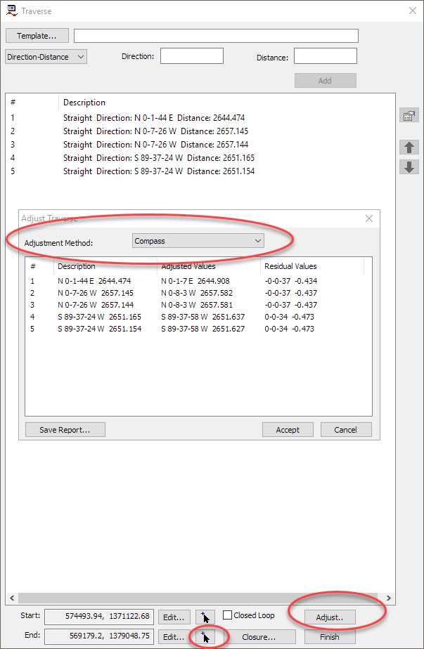
In ArcMap, the Traverse tool includes functionality to adjust a traverse, by picking a desired endpoint and using Compass Rule, Transit Rule, or Crandall Rule to make the adjustment along the traverse.
Could similar Adjust Traverse functionality be added to the Traverse tool in ArcGIS Pro?
Thank you.
- Mark as Read
- Mark as New
- Bookmark
- Permalink
- Report Inappropriate Content
ArcGIS Pro Traverse tool uses the compass adjustment method for a closed traverse. The adjustment method becomes irrelevant if you intend to adjust your data using least squares adjustment where the entire network is taken into account as opposed to a single entered traverse.
- Mark as Read
- Mark as New
- Bookmark
- Permalink
- Report Inappropriate Content
I'm not sure where this application of least squares to the entire network idea comes from. First, this makes the assumption that the network is accurate. Second, when did this change of suggestion come about? It runs contrary to ESRI's documentation going back as far as I can find, why would you ever apply a least squares adjustment to an entire network?
It is not recommended that you run a least-squares adjustment on data with dimensions that do not match the record of survey. If dimensions do not match the record of survey or plan, you can't tell how inaccurate or accurate the dimensions really are...
10.3: Parcel fabric adjustment best practices—Help | ArcGIS for Desktop
It is not recommended that you run a parcel fabric adjustment on parcels with dimensions that do not match the plan or record of survey. If dimensions do not match the dimensions of the parcel described on its plan, it is impossible to tell how inaccurate or accurate the dimensions really are...
- Mark as Read
- Mark as New
- Bookmark
- Permalink
- Report Inappropriate Content
Our County assessment and taxation cartographers constantly reconstruct and evaluate older surveys (subdivisions, partitions, etc.) as part of the mapping and remapping process. Older survey tools were not that accurate and surveyors used a variety of closure tools (such as the transit rule) to minimize error. In order to replicate and map the most accurate representation of these older surveys the cartographer must have the same closure tools of the time. This can also apply to deeds that were written using legal descriptions based on these older documents.
From the Manual of Cadastral Map Standards, Concepts & Cartographic Procedures Manual (2003):
"The rough index provides a plan for bridging the major components of this area. It also shows where information is missing. Figure 12-2 illustrates the importance of considering all surrounding surveys when developing control. For example, if our objective were to draw only section 12, it should be obvious that it would be a mistake to ignore the surveys of the abutting sections. Therefore, our compilation of surveys must extend beyond the boundaries of the area being mapped. The next step is to compare the surveys to determine which are in harmony and which maverick surveys are. Once this is done the maverick surveys should be analyzed to see why each survey does not agree with abutting survey data. There are several possibilities here. These are outlined in Chapter 6 (Surveys and Surveying). It is possible that the survey traverse merely needs to be balanced. Or, possibly the surveyor’s deflection angles and distances agree with the abutting surveys; only the bearings are different. In such cases it is possible that the surveyor has failed to convert the magnetic azimuth to true azimuth; or possibly it is only his base meridian that is in error. The main point to remember is do not ignore the survey just because it fails to agree with abutting information. Moreover, do not ignore all of the information of a survey just because part of the survey is found to be in error."
- Mark as Read
- Mark as New
- Bookmark
- Permalink
- Report Inappropriate Content
The original question was in fact related to adjusting a single traverse, and not an entire network.
Good finds in the ESRI documentation!
Is that reference for an Oregon manual? In any event, also a good find and resource!
Thank you, all.
- Mark as Read
- Mark as New
- Bookmark
- Permalink
- Report Inappropriate Content
Yes it is. The reference is the manual that is supposed to guide cartographic mapping for assessment and taxation in Oregon. To check out more info on the Oregon Map check out The Oregon Map. It has a map viewer, describes how funding for remapping to create a state-wide digital map works, and has lots of support documents. Another reference to using closure for single traverse as you suggested is also references in the ORMAP Map Methodology Revised 2008 (see Step 3). The Map Methodology was created by the ORMAP technical committee (statewide group of cartographers and gis folks and the Oregon Department of Revenue.
1. There is County Assessor and Surveyor involvement
2. All the Surveys, Subdivision maps, and digital orthoimagery that can be found in a re-mapping area are evaluated.
3. All Surveys and Subdivision maps used in the re-mapping area are reproduced using COGO (Coordinate Geometry) methods or other methods that produce the same results and are tied to PLSS (Public Land Survey System) features.
4. No COGO features are warped (rubber sheeted) from the surveyed geometry.
5. All mapping is reviewed and approved by a professional cadastral cartographer and, if necessary, in consultation with the DOR’s Cadastral Information Systems Unit.
6. A reliability level for all assessor taxmaps is determined by a test and is reviewed by a professional cadastral cartographer and included in the “MapRelCode” and “MapClass” fields.
7. All counties must be able to produce a countywide shapefile that meets the Oregon Cadastral Data Exchange Standards.
8. Metadata must be developed and meet the Oregon Metadata Standard.
- Mark as Read
- Mark as New
- Bookmark
- Permalink
- Report Inappropriate Content
Sorry to be long winded here but this is a subject close to my heart.
As Pollock, William H. (Bill) points out the answer will be different if you plan to include the data in a parcel fabric and do least squares network adjustments based record values from survey plats. Typically my process is to enter the raw survey data into the fabric and do a network adjustment based on our control. However this is not something that all fabric user may be able to do with their data and nor would I say it would be advisable in all situations. Even after I do a least squares adjustment I have to spend several hours going back and cleaning up after the adjustment where it created situations that no longer represent the intent of the record. While a lot of the work is a combination fo the poor implementation of least squares in ArcMap there are plenty of situations where it's a result of the adjustment not handling unique issues that will always require a knowledgeable and skilled user to manually edit.
It's a perfectly viable approach to adjust individual records or parcels for closure before or as part of entry to the fabric and manually handle the areas where the record meets other records. And in order to do that multiple adjustment types and the residual values are necessary.
However, my main use of the traverse adjustment has always been for analysis of survey data outside of the parcel fabric. I routinely use it analyze old metes and bounds descriptions to determine misclosure. And then using the misclosure and the residual values (which have also been removed from Pro) I can find the most likely source of the error. Then I can go back to the record and potentially other data sources to try resolve the error. Often this will include trying this will multiple adjustment types. If you are familiar with adjustments you can external use external knowledge (era of the survey, the surveyor's habits, the equipment used to collect the data, the geography and topography of the land, comments about weather and clarity of the sky during astral observations, etc) to adjust the most likely source of error and get the best adjustment result possible. Often this type of work is done in preparation of a survey or to interpret the data as best as possible in an area where a survey can't happen to meet the needs of our customers. Leaving one adjustment type and removing the residual values leaves the customer and and subject matter expert cornered into using one type even if they know it's not the most applicable adjustment type for the data at hand.
As I've included above the residual values created during the adjustment process are key to this whole process. Without the underlying data to look at and analyze none of the adjustments are really that useful for anything but making a figure close and cartographically look okay. ESRI has taken one of the most powerful analytical tools in ArcMap and butchered it to make it worse in every way.
I would to include every adjustment type that was in ArcMap but to improve upon that and give us more options. Grant Boundary is an adjustment type that is heavily used in the surveying community and is referenced and defined thoroughly in the BLM Manual of Surveying Instructions 2009. I know this is something that Tim Hodson and I have been discussing.
I strongly support what Dean Anderson said as well.
- Mark as Read
- Mark as New
- Bookmark
- Permalink
- Report Inappropriate Content
If you're interested check out this idea about including residual adjustment values and more closure information.
- Mark as Read
- Mark as New
- Bookmark
- Permalink
- Report Inappropriate Content
Please correct any of the following statements if found wrong:
- The original legal document, regardless of the year the data was recorded, does not specify the adjustment method to be used.
- The map technician accepts / rejects a traverse primarily based on the miscolse ratio. In some cases, since the document is old and recorded, even if the miscolse ratio is bad, there is no choice but to accept it.
- A free network LSA is the best way to detect blunders in a floating isolated survey network that is based on line measurements (not coordinate based cadastre).
- The adjustment methods to be used is chosen by the map technician by a process of trial and error.
- The chosen adjustment method to be used is based on the most pleasing CARTOGRAPHIC result and not on the mathematical most spatially accurate result.
- If a bad parcels abounds more recent and accurate surveys, it should be aligned to the more spatially accurate parcels regardless of the adjustment method.
- There is no algorithm that can automatically detect the best adjustment method to be used (else we can choose it automatically and save time for the ma technician).
Please provide recorded documents and data samples.
- Mark as Read
- Mark as New
- Bookmark
- Permalink
- Report Inappropriate Content
Planned as part of ArcGIS Pro 2.8
- Mark as Read
- Mark as New
- Bookmark
- Permalink
- Report Inappropriate Content
Implemented in ArcGIS Pro 2.8.
See Ideas in ArcGIS Pro 2.8 and (0:55) in the video.
You must be a registered user to add a comment. If you've already registered, sign in. Otherwise, register and sign in.