- Home
- :
- All Communities
- :
- Products
- :
- ArcGIS Parcel Fabric
- :
- ArcGIS Parcel Fabric Ideas
- :
- Add full COGO functionality to ArcGIS Pro
- Subscribe to RSS Feed
- Mark as New
- Mark as Read
- Bookmark
- Follow this Idea
- Printer Friendly Page
- Report Inappropriate Content
Add full COGO functionality to ArcGIS Pro
- Mark as New
- Bookmark
- Subscribe
- Mute
- Subscribe to RSS Feed
- Permalink
- Report Inappropriate Content
I have been working in ArcGIS Pro to test the migration to ArcGIS Pro from ArcMap. One of the job duties I have is to verify easements, annexations, and other legal descriptions. One of the concerns I have is with the release of the Traverse tool. While it has been nice to work with, currently I am not seeing Grid to Ground Correction functionality as well as the ability to COGO area descriptions into a polygon format. Is there something I am missing with the latest version of ArcGIS pro or is the functionality not there as of yet?
Ground to Grid functionality in ArcMap would have corrected for this error (as much as it is).
See attached image, disregard the polygon as that is for the third portion of my question.
Secondly, is there directional control for non-tangent curves? See my legal description example.
Example: "thence 4.32 feet along the arc of a non-tangent curve to the right, said curve having a radius of 326.00 feet, a delta angle of 00-45'34", and a long chord bearing 74-57'30" East, 4.32 feet to a point of compound curvature"
Currently I have not seen any way to enter curve direction for non-tangent curves in ArcGIS Pro. Is there a tool or command that I am missing here as well?
Third and final question for entering in legal descriptions for areas such as Annexations and Easements (all forms). I have not seen tool functionality or ability to enter in legal descriptions for areas. The polygon that is in the picture is one that I traced over top of the transverse that I created to test the tool. Is there something I am missing here as well?
Thanks.
- « Previous
-
- 1
- 2
- 3
- 4
- 5
- Next »
- Mark as Read
- Mark as New
- Bookmark
- Permalink
- Report Inappropriate Content
Hi Margaret,
Thanks for your input.
I have uploaded a video that shows how you can save a traverse and pick it up from where you have left using ArcGIS Pro.
Here is the LINK.
- Mark as Read
- Mark as New
- Bookmark
- Permalink
- Report Inappropriate Content
Thank you very much. This answers my question
Margaret
- Mark as Read
- Mark as New
- Bookmark
- Permalink
- Report Inappropriate Content
I've just noticed this following the upgrade to Pro 2.3... Thanks!
- Mark as Read
- Mark as New
- Bookmark
- Permalink
- Report Inappropriate Content
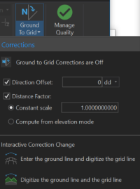
Hi...I installed the ArcPRO 2.3 and used the Ground to Grid tool. Great, and happy to see that that function is also included in the HELP menu.
My only problem, which is a real problem for me, is when I apply the enter ground line and digitize the grid line option, my pointer will not snap to my ground control points. I have engaged the snapping tool in the edit ribbon and also the list of snapping function in the Contents menu. Was this overlooked or am I missing an action I need to engage?
Thanks,
Margaret
- Mark as Read
- Mark as New
- Bookmark
- Permalink
- Report Inappropriate Content
Here is where we are on COGO functionality in ArcGIS Pro:
Timeline on COGO related tools
Existing COGO tools already available in released Pro (2.3 and earlier):
- COGO Traverse
- Ground to Grid corrections (including automated combined scale factor calculation using constant elevation or elevation surfaces)
- Divide line by proportion (+ stores typed COGO attributes, and supports ground to grid correction where appropriate)
- Divide polygon by Area, width, proportion from a starting polygon edge.
- Direction-Distance, Direction, and Distance constraints enhanced to store typed COGO attributes (and supports ground to grid correction )
- Fillet tool enhanced to store typed Radius values to COGO attributes (and ground to grid)
New COGO tools coming out with 2.4 (June/July 2019):
- Update COGO (Inverse)
- Divide Polygon enhanced to allow directly entered bearing line, example divide polygon by area using a north-south line
- Circular arcs (non-tangent as well as tangent to existing lines)
- Intersection by inference
- Offset tool (for station and offset)
- Ground to grid support for Copy parallel
- Feature Alignment enhanced with an option to avoid introduction of vertices (example to prevent an aligned circular arc from becoming degenerated into densified lines)
- Sequential naming tool (name features using a string pattern, and drawing a line to define the sequence of number incrementing)
COGO tools coming not in 2.4, planned for post 2.4:
- Spiral curve
- Other adjustment methods for Traverse
- Intersection by start points and typed Direction entry values
- Widen
- COGO Report/Calculator/Measure
- Split into COGO Lines (equivalency with ArcMap COGO Toolbar)
- Create 2-point lines (equivalency with ArcMap COGO Toolbar)
- Least squares adjustment
- And https://community.esri.com/ideas/15385-arcgis-pro-support-for-importing-and-exporting-traverse-files
- Mark as Read
- Mark as New
- Bookmark
- Permalink
- Report Inappropriate Content
Thank for the update Kory. Is there an estimated timeline available for implementation of the ability COGO in polygons directly without having to construct them from lines? Amir mentioned that this was only an interim solution back in 2017 so I was wondering if that was still a planned feature.
- Mark as Read
- Mark as New
- Bookmark
- Permalink
- Report Inappropriate Content
+ Amir Bar-Maor ?
Is there an estimated timeline available for implementation of the ability COGO in polygons directly without having to construct them from lines?
- Mark as Read
- Mark as New
- Bookmark
- Permalink
- Report Inappropriate Content
Any additional update?
- Mark as Read
- Mark as New
- Bookmark
- Permalink
- Report Inappropriate Content
Still waiting on direct COGO functionality for polygons... (and not re-creating them from lines), any update on this? I would love to upgrade my team to PRO, but this is a serious limitation that we have to use Desktop for.
- Mark as Read
- Mark as New
- Bookmark
- Permalink
- Report Inappropriate Content
Hi David,
I attended the Parcel meetup webinar last week and asked this question. As of right now, it doesn't seem like they plan to add the ability to COGO in polygons. They told me the intended workflow is to use Parcel Fabric, if you looking to maintain parcels and to use the construct polygons tool for anything else. Hope this is helpful.
You must be a registered user to add a comment. If you've already registered, sign in. Otherwise, register and sign in.