Hello Land Records Folks!
We have just published a tool that allows you to migrate your ArcMap COGO feature classes into the new ArcGIS Pro COGO Enabled line feature class schema. Those Text fields that contained your COGO information will be converted to the numerical (Double) field type and all the values will be carried over.
Where Is This Tool?
You can find the tool here: https://bit.ly/2GFEiNl
Download the zip and unpack it to find the tool. In the future more tools will be added. We will notify you when this happens so you can re-download the tool box to get all the new changes.
How Do I Use This Tool?
Once you have the toolbox unpacked from the Zip browse to it in the Catalog Pane in ArcGIS Pro by adding a folder connection to the tools location. You can then right click the toolbox and say Add To Project and this will and the tool box to the Toolboxes group in the Catalog pane for easy access in the future. Finally, to run, double click the tool. You will be presented with 3 options:
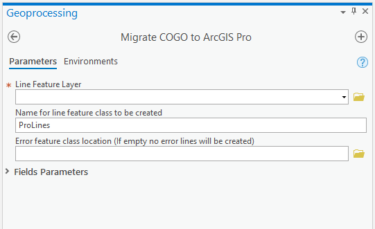
1. First you will point to the Line Feature that you want to migrate
2. Then you will provide a name for the new line feature class that will be created by running this tool.
3. Optionally you can then provide a name for an error feature class. This error feature class will have all the line geometries that failed to properly migrate the COGO values. You can use this to update the new COGO feature class created.
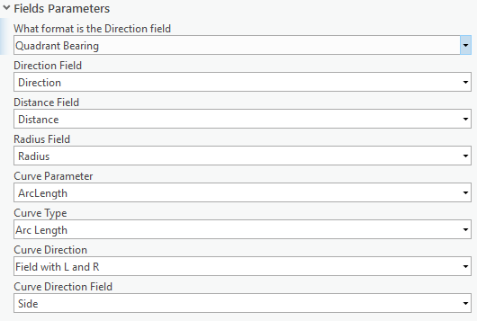
Field Mapping:
If you have a standard ArcMap COGO enabled Line feature class then there won't be any field mapping necessary. But if you have a different field that you are using to represent COGO measurements you can field map them in this area. Additionally if your COGO Direction Field is using North Azimuth you can adjust how that format is handled here. Just change the first drop down from Quadrant Bearing to the North Azimuth.
I Have Questions
Please feel free to reply to this blog post or comment on the ArcGIS Online Item and we will get back to you as soon as possible.
Thanks!
Jason Camerano
