ArcGIS Parcel Fabric Blog

cancel
Showing results for 
Show  only  | Search instead for 
Did you mean: 

Other Boards in This Place

Latest Activity

(21 Posts)
TimHodson
Esri Contributor

An add-in is available for anyone who'd like to use scale, rotate, and translate parameters to move their CAD data sets from "ground" into a projected coordinate system.


Read more...

more
4 2 4,408
AmirBar-Maor
Esri Regular Contributor

Parcel FabricParcel Fabric

Read more...

more
3 1 595
AmirBar-Maor
Esri Regular Contributor

If you want to see the records name of a parcel, line or point in the popup, you can do that by using an Arcade expression.

Here are the steps:

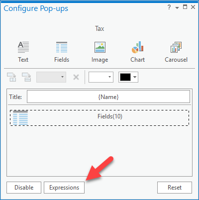
1. Right click on the layer --> Configure Popups

2. Press the Expressions on the bottom

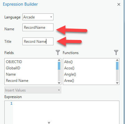
3. press New to add a new expression and give it a name and a title:

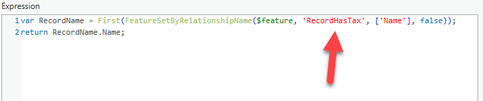
4. Add this expression 

var RecordName = First(FeatureSetByRelationshipName($feature, 'RecordHasTax', ['Name'], false));
return RecordName.Name;

5. Modify the name of the relationship class (bolded above)

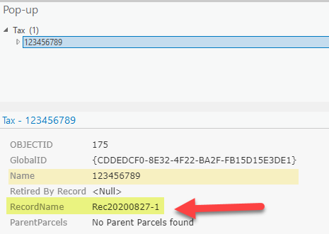
6. Test by clicking on a feature (you can apply this to a parcel, boundary line, connection line and points)

Let me know if you find this example useful?

more
3 6 1,053
AmirBar-Maor
Esri Regular Contributor

In this video I would like to show how you can  pick up a traverse from where you have left (don't forget to save edits) by using the traverse modify functionality in ArcGIS Pro. 

You can also use the modify functionality to correct an error in a previously entered traverse.

There is no longer need to save to a text file,, just save your edits as features to your geodatabase.


I have also included the legal description if you want to practice (you can really start from any location for practice purposes)

Legal Description

more
3 3 3,757
AmirBar-Maor
Esri Regular Contributor

If you are using ArcGIS Pro 2.3 or earlier you can use the attached layer file (LYRX) and point it to your data to get the layer that is used in this video.

Here is the link to the Arcade expression language.

more
1 0 1,163
AmirBar-Maor
Esri Regular Contributor

It is easy to create a COGO enabled line feature class.

See attached video.

To learn more about the geoprocessing tool read this documentation.

Why Enable COGO?

  1. All your entered measurements are stored as attributes.
  2. When a COGO enabled line feature class is added to the map it comes with great default symbology and labeling.
  3. Label expression is configurable.

.

more
3 0 1,716
215 Subscribers