- Home
- :
- All Communities
- :
- Products
- :
- ArcGIS Online
- :
- ArcGIS Online Questions
- :
- Re: Update coordinate system of hosted feature lay...
- Subscribe to RSS Feed
- Mark Topic as New
- Mark Topic as Read
- Float this Topic for Current User
- Bookmark
- Subscribe
- Mute
- Printer Friendly Page
Update coordinate system of hosted feature layer?
- Mark as New
- Bookmark
- Subscribe
- Mute
- Subscribe to RSS Feed
- Permalink
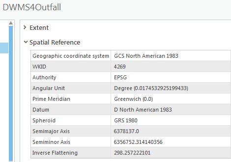
Is it possible to update the coordinate system of a hosted feature layer in ArcGIS Pro without overwriting it? I published a hosted feature layer (DWMS4Outfall) and it looks like I forgot to set the projected coordinate system to NAD 1983 StatePlane California VI FIPS 0406 Feet. Other layers I published show both PCS and GCS under Spatial Reference (e.g., RWStation). If I need to republish/overwrite, how can it be done without losing the attachments?
Thanks for the help.

Solved! Go to Solution.
Accepted Solutions
- Mark as New
- Bookmark
- Subscribe
- Mute
- Subscribe to RSS Feed
- Permalink
You cannot directly change the coordinate system in online feature service once published.
As you indicated, one way to achieve this is to export the data in online to filegdb (with attachments), then open this data in ArcMap or Pro, change the coordinate system and then overwrite the data in online. This should work.
Thanks
Khaled Hassen
- Mark as New
- Bookmark
- Subscribe
- Mute
- Subscribe to RSS Feed
- Permalink
I just did the same thing mentioned here. We really need the ability to set the coordinate system in AGOL. I come from an SDE environment where I didn't have to worry about it. I noticed the issue when my square footage didn't make sense. I realize it was being reported in square meters instead since it was Web Mercator. I didn't get too far so I can probably just start over.
Principal Planner
City of Arkansas City
- Mark as New
- Bookmark
- Subscribe
- Mute
- Subscribe to RSS Feed
- Permalink
Not really understand the issue. We do support publishing data into any coordinate systems.
However once the data is published, you can change the coordinate system since this would requires reprojecting the existing data. Also area and length reported in the layer query is based on the data spatial reference. BTW, these are not geodetic. You can use returnGeodetics in the query API to get more accurate measurements.
Thanks
Khaled
- Mark as New
- Bookmark
- Subscribe
- Mute
- Subscribe to RSS Feed
- Permalink
I created the hosted feature layer in ArcGIS Online. It automatically went with Web Mercator. I don't remember seeing an option to choose a different projection/coordinate system. I should have noticed this sooner but like I said I'm used to SDE and feature datasets that all of the same coordinate system so i didn't have to check. It seems in order to create something in a different system would require the feature class to be created in Pro or ArcMap and loaded into ArcGIS Online. Not a huge deal, just a learning experience.
Principal Planner
City of Arkansas City
- Mark as New
- Bookmark
- Subscribe
- Mute
- Subscribe to RSS Feed
- Permalink
Yes you need to publish SD file to bypass the default SR which is web Mercator if you are using Pro or even arcgis.com UX.
The UX does not expose the targetSR param we support at publishing.
So you can use the portal Publish API directly without the UX and you should be able to override the default behavior and specify any target spatial reference as a publishing param.
Publishing param in portal can contain:
{
"name" : "<yourname>",
"targetSR" : { "wkid" : <>"}
}
You can check how the UX is publishing from arcgis.com UX (fiddler, etc.). It does call the portal publishing from your data source.
Thanks
Khaled
- Mark as New
- Bookmark
- Subscribe
- Mute
- Subscribe to RSS Feed
- Permalink
Can you give more details about how to convert through ArcGIS Pro? I am using the project tool to reproject the table from one coordinate system to another. However, after the convert linked relationship table and contingent values setup all disappeared for the new table.
- Mark as New
- Bookmark
- Subscribe
- Mute
- Subscribe to RSS Feed
- Permalink
Hi @KhaledHassen I tried this and changed the coordinate system on the layer, right click >> Share and Overwrite, but the cs did not update. The steps only worked for me once I changed the coordinate system of the map as well, so it seems like no matter what the layer is in, it will publish based on the map. Just an FYI for anyone else reading this (my layer is in Portal 10.8.1)
- Mark as New
- Bookmark
- Subscribe
- Mute
- Subscribe to RSS Feed
- Permalink
I had a similar experience but with a solution that I was applying to ArcGIS Enterprise 10.9.1. Solution is Lead Service Line Inventory (only version 1.0 is available for 10.9.1). During the installation of the solution, it asks for a Coordinate System and I gave it ours (wkid 2881...State Plane HARN Florida East US Feet). It ignored that coordinate system and left it in Illinois State Plane (Naperville).
- Mark as New
- Bookmark
- Subscribe
- Mute
- Subscribe to RSS Feed
- Permalink
Did you ever find a fix for this? I had a similar thing happen with the LSL solution. Previous versions of the LSL Solutions used to default to WGS 1984 WKID 102100. Now you have to select your coordinate system (in AGOL, this seems like an overkill to take the default setting away and make you search for it manually, since all other hosted layers work in Web Mercator by default). It failed to produce 102100 through the search and just gave me "WGS 1984". Once I had deployed all the solutions and looked at the layer in Pro I was able to see that it selected WGS 1984 WKID 4326 which causes significant distortion to the map. The only "Solution" I have found is to delete and redeploy but I am still unable to find the WGS 1984 102100 coordinate system when I try to do that. Yes, you can re-project by setting the coordinate system in your map, in Pro, but not all users will be accessing the Services layer through Pro. I just wish the search feature at the beginning of the deployment worked.