- Home
- :
- All Communities
- :
- Products
- :
- ArcGIS Online
- :
- ArcGIS Online Questions
- :
- Re: Tiled image in ArcGIS Online does not let me z...
- Subscribe to RSS Feed
- Mark Topic as New
- Mark Topic as Read
- Float this Topic for Current User
- Bookmark
- Subscribe
- Mute
- Printer Friendly Page
Tiled image in ArcGIS Online does not let me zoom in far
- Mark as New
- Bookmark
- Subscribe
- Mute
- Subscribe to RSS Feed
- Permalink
- Report Inappropriate Content
I have published a tiled image and I have set the visibility range to the max. However, it doesn't stay. Take a look:
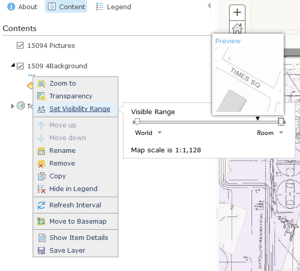
But, as soon as I set it, and zoom it, it changes back to its own preset default for no good reason. Is there any way around this? Is this a bug in ArcGIS Online?
Please help!
A link to the web map: http://arcg.is/2fouTew
Solved! Go to Solution.
- Mark as New
- Bookmark
- Subscribe
- Mute
- Subscribe to RSS Feed
- Permalink
- Report Inappropriate Content
Thanks again,
I did read through the post in its entirety, but the above instructions are confusing to me. Am I to take the above to mean that the only way to access the "admin directory" is to hard code in a URL? I tried entering it as it's written and filling in the information for my organization/service, but receive a "Server Not Found" error. This leads me to believe I'm typing something in incorrectly-perhaps I'm not entering my <org-id> right? Do you have any ideas for how I might determine where my error is?
- Mark as New
- Bookmark
- Subscribe
- Mute
- Subscribe to RSS Feed
- Permalink
- Report Inappropriate Content
If you look at the service directory that opens from the item details page, add the word admin between rest and service to access the admin directory:
Example Service URL:
http://tiles.arcgis.com/tiles/6tVsHR2ERRUR1RFd/arcgis/rest/services/PinkYeti/MapServer
Admin URL:
http://tiles.arcgis.com/tiles/6tVsHR2ERRUR1RFd/arcgis/rest/admin/services/PinkYeti/MapServer
Share the url that you are using or send it to me as a message if you are still unable to access the admin.
-Kelly
- Mark as New
- Bookmark
- Subscribe
- Mute
- Subscribe to RSS Feed
- Permalink
- Report Inappropriate Content
Thank you!
I tried this earlier with no luck, but I could have been entering it in the wrong place. This seems to have worked. I will update when I have time to try to the resampling. Thanks again!
- Mark as New
- Bookmark
- Subscribe
- Mute
- Subscribe to RSS Feed
- Permalink
- Report Inappropriate Content
Kelly Gerrow and anyone else!
Q -In addition to the resampling parameter and max scale, what other service properties need to be modified to show the cache below the original lowest scale?
It appears the example link you provided (including my own hosted tile layers) still shuts off below 1128 even with resampling on and the max scale property =71. Is that what everyone else is seeing or maybe I'm missing something? (wouldn't be the first time, and won't be the last!)
Both of our services (we have same the cache scales, max scales, and resampling properties) only show through LOD ID 19, even though we've explicitly set max scale to 1:71 (or LOD ID 23) and have resampling on. Once you zoom below to LOD 20/1:564 and lower, our layers shut off (and cannot be turned on).
Important side note - using this workflow for ArcGIS Server Services
I was able to successfully use this workflow for my ArcGIS Server cache map service (and image services) to display below its LOD ID 19, however, I had to take one more step: I had to run the "Manage Map Server Cache Scales" tool in ArcGIS Desktop in order to add the LOD's to my service. This created the extra LOD's in my service, albeit empty tiles (which is what I want - to just show the tiles from LOD 19 at levels 20 thru 23 instead of generating a cache for those levels). Only after I completed this step, did my cache stay on (resample) at LOD 20-23.
Q - My experience using ArcGIS Server/Desktop to get this to work leads me to wonder if there is a similar function available using the Rest Admin Interface in the hosted environment (tiles.arcgis.com admin)?
Q - Does the "edit" function allow syntax that would enable you to add another level of detail, similar to the running the ArcGIS Desktop tool "Manage Map Server Cache Scales" on a cached map service?
I did try running the Manage Map Server Cache Scale tool against my Hosted Tile Layer, but I get blocked (probably rightfully so due to access constraints) with an error code: ERROR 001195: Could not connect to the caching service on the server. The caching GP service may not be running on the server./failed to execute.
Any advice would be great! I think i'm all hacked-out until I get some input from the community. thanks!
- Mark as New
- Bookmark
- Subscribe
- Mute
- Subscribe to RSS Feed
- Permalink
- Report Inappropriate Content
Did you get this worked out Ryan? I'm having the same issue after setting resampling to true (ArcGIS Online).
- Mark as New
- Bookmark
- Subscribe
- Mute
- Subscribe to RSS Feed
- Permalink
- Report Inappropriate Content
Yeti, lol!
- Mark as New
- Bookmark
- Subscribe
- Mute
- Subscribe to RSS Feed
- Permalink
- Report Inappropriate Content
Dear Kelly,
I recently came across this same problem and found your brilliant solution. However, I am trying to get it work, but still I have not been able to do it so far. I hope you could help me, and I thank you in advance. Here is what I did...
- I have a public tiled service on my AGOL (rest: Services Directory - AltaValtellina2_WTL1(MapServer) )
- I eneterd in the admin page and added {"resampling":true} in the (previously empty) "Service definition" box, and clicked "Edit Tile Service"
- I now see "Resampling true" in the service page
- I came back to AGOL, repoened the TileSerivce in a new map, but as I zoom below level 15 of scale (last level for which the tile was generated, the image disappear (as before).
Did I miss something? Also, will this be possible for ArcGIS Server services as well?
Looking forward to hearing from you, thanks again!
- Mark as New
- Bookmark
- Subscribe
- Mute
- Subscribe to RSS Feed
- Permalink
- Report Inappropriate Content
Hi Allessandro,
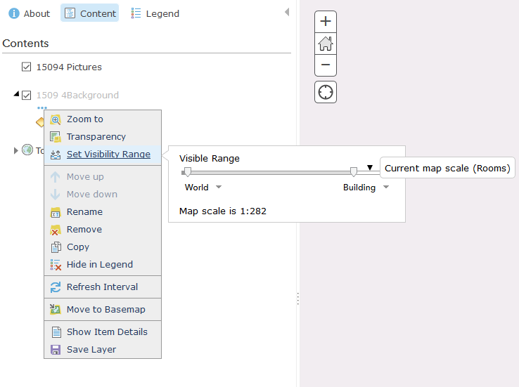
The service you provided has scale dependency set on it so that the layer stops appearing when you zoom in past: 18055.954822, level 15, this is why the layers are disappearing. You can change this in the web map or at the service level. To change in the webmap, click on the 3 dots under the layer and then the set visibility range. Modify the visibility range to the entire range available and save your webmap. Here is a sample: https://cloudygis.maps.arcgis.com/home/webmap/viewer.html?webmap=acaeff71d61a46e9a4cd27e83f773e0d
You could also republish you service and ensure that the visibility range includes all of the available scales, or modify the max scale using the same edit call referenced above.
-Kelly
- Mark as New
- Bookmark
- Subscribe
- Mute
- Subscribe to RSS Feed
- Permalink
- Report Inappropriate Content
Hi Kelly,
i have the sampe problems in this map with the Demo02_WTL1 image.
I've setted the "resample:true" parameter, I've setted the visibility range, but I still cannot see the image at large scale. Can you help me?
- Mark as New
- Bookmark
- Subscribe
- Mute
- Subscribe to RSS Feed
- Permalink
- Report Inappropriate Content
Yep, that made it! Thank you so much, right and to the point, I haven't noticed it. Also very fast response.