- Home
- :
- All Communities
- :
- Products
- :
- ArcGIS Online
- :
- ArcGIS Online Questions
- :
- Symbols with more than two layers doesn't show cor...
- Subscribe to RSS Feed
- Mark Topic as New
- Mark Topic as Read
- Float this Topic for Current User
- Bookmark
- Subscribe
- Mute
- Printer Friendly Page
Symbols with more than two layers doesn't show correctly in feature service
- Mark as New
- Bookmark
- Subscribe
- Mute
- Subscribe to RSS Feed
- Permalink
- Report Inappropriate Content
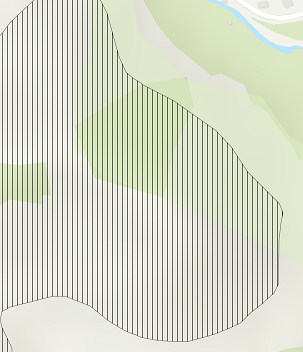
I am using ArcMap 10.3.1. I have published some polygons as a feature service to ArcGIS Online. The problem is that the symbol of some polygons doesn't show correctly.
After a brief inspection, I found that the problem is originated from the number of layers to define a symbol. If more than two layers are used in a symbol, only the first layer of the symbol will be shown in the feature service. For example, Figure 1 shows that the symbol definition of a polygon in Arcmap has two layers. And Figure 2 shows the same symbol when it is published to the web as a feature service. Only the vertical lines are displayed on the web. How can I show all layers defined in a symbol with correct colors when publishing a feature server?
Figure 1: Symbol definition in Arcmap
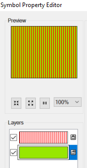
Figure 2: Symbol of the Polygon in Web