- Home
- :
- All Communities
- :
- Products
- :
- ArcGIS Online
- :
- ArcGIS Online Questions
- :
- Re: Shift between my published services and ArcGIS...
- Subscribe to RSS Feed
- Mark Topic as New
- Mark Topic as Read
- Float this Topic for Current User
- Bookmark
- Subscribe
- Mute
- Printer Friendly Page
Shift between my published services and ArcGIS Online Base Maps
- Mark as New
- Bookmark
- Subscribe
- Mute
- Subscribe to RSS Feed
- Permalink
- Report Inappropriate Content
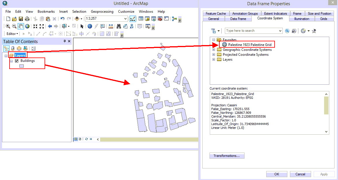
I have a map that contains a layer in “Palestine 1923 Grid WKID= 28191”, when publishing this map via ArcGIS online and adding it to an ArcGIS online map, the layer of the map service is shifted from the ArcGIS online base map.
The same thing happens with services published by ArcGIS Server!
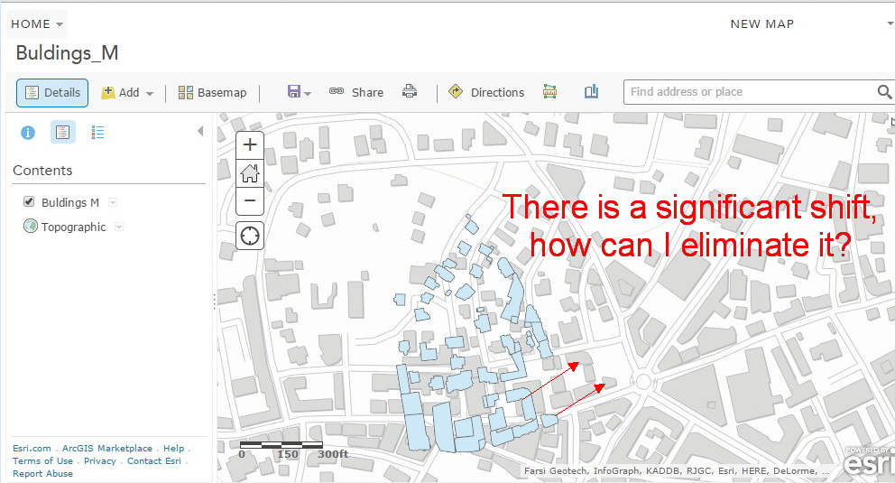
This is better illustrated with the screenshots below
How can I publish my services and add them to ArcGIS online maps with no shifts between them and ArcGIS online base maps?
Note: The coordinates of the features in the layer are accurate and have been verified by an accurate GPS
Any help is appreciated,
Hani
1- The map in ArcMap
2- The map is published as ArcGIS online service

3- This ArcGIS Online service is added to the ArcGIS online map, and there is a shift between it and the imagery base map.
Solved! Go to Solution.
- Mark as New
- Bookmark
- Subscribe
- Mute
- Subscribe to RSS Feed
- Permalink
- Report Inappropriate Content
Thank you for your valuable response Tim,
Actually, I have multiple map services which contain layers in "Palestine 1923 Grid" PCS, and it will take me a long time to re-project them to WGS 1984 Web Mercator (auxiliary sphere) GCS.
I think that Kelly's solution (using my own basemap) can resolve the problem with minimum changes.
I tried your suggestion for a single map service, but still, there is a shift between Esri standard basemaps and my services, I think that this happened because I did not use the right transformation (which I do not know). By the way, do you have an idea of how I can find the right transformation between two coordinate systems. For example between the "Palestine 1923 Grid" and the WGS 1984 Web Mercator (auxiliary sphere)?
Once again, thank you very much for the contribution
- Mark as New
- Bookmark
- Subscribe
- Mute
- Subscribe to RSS Feed
- Permalink
- Report Inappropriate Content
Unfortunately, I don't know which transformation to use during the re-projection, there are no suggested transformations listed in ArcMap when doing the export. I see that the Palestine 1923 Grid is based on a Cassini projection and a Clarke_1880_Benoit spheroid, which will come into play with the transformation, but you may need to work with someone at Esri to get some guidance on this.
Tim
- Mark as New
- Bookmark
- Subscribe
- Mute
- Subscribe to RSS Feed
- Permalink
- Report Inappropriate Content
Hani,
Have you found the right transformation for your data (with GCS_Palestine_1923 WKID: 4281 Authority: EPSG) to be converted into WGS 1984 Web Mercator auxiliary sphere (WGS_1984_Web_Mercator_Auxiliary_Sphere WKID: 3857 Authority: EPSG)?
If not yet, please try 'Palestine_1923_To_WGS_1984_1' in ArcGIS
- Mark as New
- Bookmark
- Subscribe
- Mute
- Subscribe to RSS Feed
- Permalink
- Report Inappropriate Content
Many Thanks Larry
You are right! I tried this transformation and it worked fine!
- « Previous
-
- 1
- 2
- Next »
- « Previous
-
- 1
- 2
- Next »