- Home
- :
- All Communities
- :
- Products
- :
- ArcGIS Online
- :
- ArcGIS Online Questions
- :
- Polygon outline symbology - automatically decreasi...
- Subscribe to RSS Feed
- Mark Topic as New
- Mark Topic as Read
- Float this Topic for Current User
- Bookmark
- Subscribe
- Mute
- Printer Friendly Page
Polygon outline symbology - automatically decreasing width on polygons?
- Mark as New
- Bookmark
- Subscribe
- Mute
- Subscribe to RSS Feed
- Permalink
- Report Inappropriate Content
Hello,
I'm trying to make an ArcGIS Online map showing different polygons (Neighborhoods). I have the transparency high when zoomed in so you can see the basemap underneath, but I want thick outlines so you can clearly see the boundaries of the polygons. Here's what happens though:
1) I make one polygon boundary think
2) I change another polygon width
3) The original one reverts back to being thin
Does anyone know why this is happening?
Solved! Go to Solution.
Accepted Solutions
- Mark as New
- Bookmark
- Subscribe
- Mute
- Subscribe to RSS Feed
- Permalink
- Report Inappropriate Content
Andrew Wallick Xander Bakker A fix for this issue is planned to go out tonight (PDT).
Thanks for reporting,
Chris
- Mark as New
- Bookmark
- Subscribe
- Mute
- Subscribe to RSS Feed
- Permalink
- Report Inappropriate Content
That really looks like a bug (and yes I was able to reproduce this behavior). Could you contact Esri support and notify them?
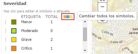
There is a way to change the outline of all the polygons which seems to work (without editing the json of the element). In the symbol editor there is a button (see red outline in image below) that allows to change all the symbols (sorry for the Spanish interface):
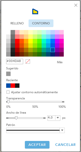
Change the outline to the width, transparency, color, etc you want to assign:
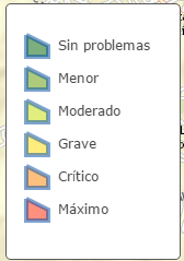
... and click OK. It will assign it to all the symbols:
Be aware, if you change a single symbol afterwards (for instance the fill color without touching the outline symbol settings, all other outline will reset to the default again. So you should start with the fill colors and end with the outlines.
- Mark as New
- Bookmark
- Subscribe
- Mute
- Subscribe to RSS Feed
- Permalink
- Report Inappropriate Content
Andrew Wallick Xander Bakker A fix for this issue is planned to go out tonight (PDT).
Thanks for reporting,
Chris