- Home
- :
- All Communities
- :
- Products
- :
- ArcGIS Online
- :
- ArcGIS Online Questions
- :
- Re: Point shapefile XY coordinates problem with Ar...
- Subscribe to RSS Feed
- Mark Topic as New
- Mark Topic as Read
- Float this Topic for Current User
- Bookmark
- Subscribe
- Mute
- Printer Friendly Page
Point shapefile XY coordinates problem with ArcGIS online
- Mark as New
- Bookmark
- Subscribe
- Mute
- Subscribe to RSS Feed
- Permalink
- Report Inappropriate Content
I have three dataset: two rasters and one point shapefile which I would like to add to my map in ArcGIS online. All of data have the same projected coordinate system, however after importing them to ArcGIS online map the points are shifted few meters to south-west with respect to my raster data. What should I do to correct it? Which reference system should I use to be sure that my data are displayed correctly?
- Mark as New
- Bookmark
- Subscribe
- Mute
- Subscribe to RSS Feed
- Permalink
- Report Inappropriate Content
When you view the data in ArcMap does it align correctly?
What coordinate system is this anyway?
- Mark as New
- Bookmark
- Subscribe
- Mute
- Subscribe to RSS Feed
- Permalink
- Report Inappropriate Content
In ArcMap everything works fine. The details of the spatial references I am using are attached below.
Data Type: Shapefile Feature Class
Geometry Type: Point
Coordinates have Z values: No
Coordinates have measures: No
Projected Coordinate System: CH1903_LV03
Projection: Hotine_Oblique_Mercator_Azimuth_Center
false_easting: 600000.00000000
false_northing: 200000.00000000
scale_factor: 1.00000000
azimuth: 90.00000000
longitude_of_center: 7.43958333
latitude_of_center: 46.95240556
Linear Unit: Meter
Geographic Coordinate System: GCS_CH1903
Datum: D_CH1903
Prime Meridian: Greenwich
Angular Unit: Degree
- Mark as New
- Bookmark
- Subscribe
- Mute
- Subscribe to RSS Feed
- Permalink
- Report Inappropriate Content
What is the extent?
Think Location
- Mark as New
- Bookmark
- Subscribe
- Mute
- Subscribe to RSS Feed
- Permalink
- Report Inappropriate Content

- Mark as New
- Bookmark
- Subscribe
- Mute
- Subscribe to RSS Feed
- Permalink
- Report Inappropriate Content
I believe that you should re-project Project—Help | ArcGIS Desktop this data to GCS_WGS84 before uploading to AGOL.
"Projected Coordinate System: CH1903_LV03", is based on GCS_CH1903 and will require a datum transformation as well. There are several available in the system.
- Mark as New
- Bookmark
- Subscribe
- Mute
- Subscribe to RSS Feed
- Permalink
- Report Inappropriate Content
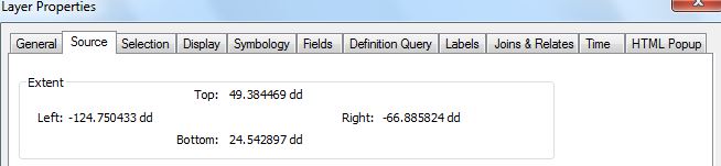
Could you also attach a screenshot of the spatial extent of the point layer from ArcMap (Layer Properties > Source)?
Think Location