- Home
- :
- All Communities
- :
- Products
- :
- ArcGIS Online
- :
- ArcGIS Online Questions
- :
- Re: Flow Direction Arrows - ArcGIS Online
- Subscribe to RSS Feed
- Mark Topic as New
- Mark Topic as Read
- Float this Topic for Current User
- Bookmark
- Subscribe
- Mute
- Printer Friendly Page
Flow Direction Arrows - ArcGIS Online
- Mark as New
- Bookmark
- Subscribe
- Mute
- Subscribe to RSS Feed
- Permalink
- Report Inappropriate Content
Any thoughts on how to get this to work or what may be causing this?
Thanks in advanced and God bless!
Matthew
- Mark as New
- Bookmark
- Subscribe
- Mute
- Subscribe to RSS Feed
- Permalink
- Report Inappropriate Content
I know this is several years after the fact, but for people who are experiencing this problem for the first time, I wanted to let them know that you can symbolize a line feature with a directional arrow in the web map itself.
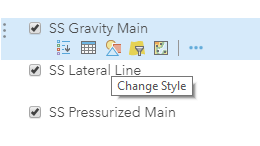
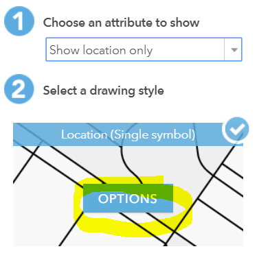
In the Table of Contents, locate the layer. If needed, expand the service layer to get to the data layer itself. Hover the mouse pointer over the symbols and click on Change Style
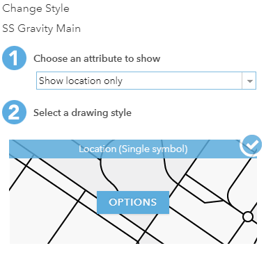
In the Change Style window, click on the OPTIONS button:
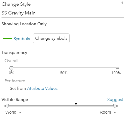
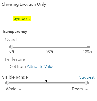
Click on the blue Symbols text:
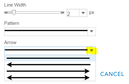
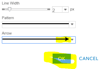
Drop-down the Arrow picker and choose the left to right arrow:
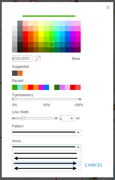
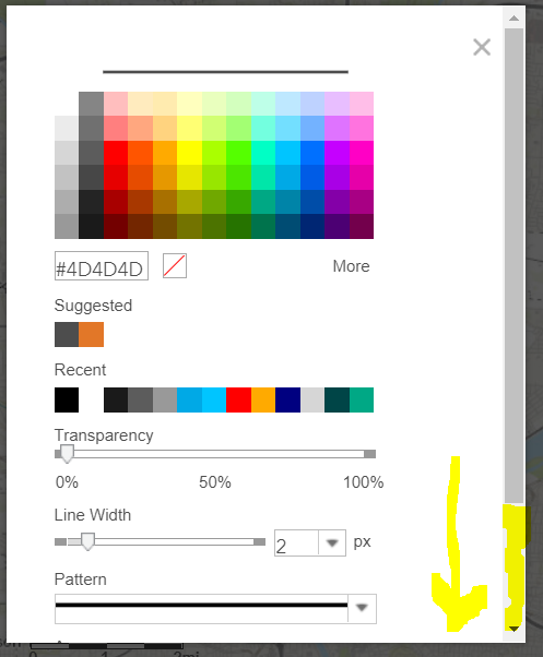
Symbolize the line weight and color as you choose. Click Ok, then Ok, and then Done. The symbology should now be visible on the map. **Note that there will only be ONE arrow at the end of the line, not several arrows along the line--that's still not an option as far as I know**
It doesn't look as refined as a cartographic line in an .mxd, but it does the job. The arrows will point in the direction it was digitized in (in this example, we digitize sanitary sewers from high elevation to low elevation, so the arrows point downstream).
Again, I know that this is really late, but it took me several hours a few months ago to figure this out. Hope it helps someone else in the future.
- Mark as New
- Bookmark
- Subscribe
- Mute
- Subscribe to RSS Feed
- Permalink
- Report Inappropriate Content
Has the drop-down to choose an arrow gone away?
I ran into this problem yesterday and was happy to find there was a solution--however, in my view of the box above I have no drop-down for an Arrow, only Pattern.
Am I missing something?
- Mark as New
- Bookmark
- Subscribe
- Mute
- Subscribe to RSS Feed
- Permalink
- Report Inappropriate Content
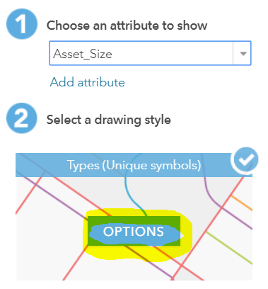
Hi Misti, I still see the option for arrows. When you are symbolizing by location only, choose the Options button:
Then click on the Symbols link:
Then Scroll Down:
Drop down the arrow selector and choose the arrow you need:
Click OK when the arrow has been selected:
If you are symbolizing by Unique Type, you need to take this step for each type in the list:
Hover over each line type and click to change the symbol:
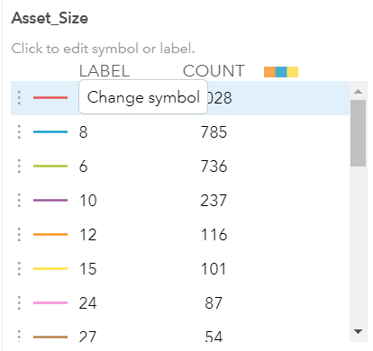
Scroll down to see the arrow selector, choose the arrow, and then click OK.
Repeat for each line type.
Hope this helps!
- Mark as New
- Bookmark
- Subscribe
- Mute
- Subscribe to RSS Feed
- Permalink
- Report Inappropriate Content
Has this been fixed? I know you can place arrows at the endpoints, but I really need to be able to place them at intervals along the line. Is that possible to do yet? The problem with using the endpoints is that the area gets really noisy with the node and its label (in our case manholes) and up to four lines connected.
- Mark as New
- Bookmark
- Subscribe
- Mute
- Subscribe to RSS Feed
- Permalink
- Report Inappropriate Content
I agree, I'd really like to see this problem fixed. It's causing a lot of problems for my web map and my client.
- Mark as New
- Bookmark
- Subscribe
- Mute
- Subscribe to RSS Feed
- Permalink
- Report Inappropriate Content
Buenos días,
Yo tengo el mismo problema que ustedes. Intento representar el flujo del tráfico de las vías. Es decir el sentido por el que se puede circular. El problema que poniendo solo la flecha al comienzo o al final no lo interpreta bien. Lo suyo sería un patrón de línea con flecha que se repitiera a lo largo de la entidad. (yo no lo he encontrado!)
La solución que yo le he dado, ha sido colocando caracteres ">>", "<<" o "<< >>" en la etiqueta junto al nombre de la calle. Para hacer que se muestre un sentido u otro he creado una expresión con arcade que comprueba el campo sentido. Adjunto imagen por si le ayuda a alguien.
Si se ocurre mejor solución, os agradezco la ayuda.
- Mark as New
- Bookmark
- Subscribe
- Mute
- Subscribe to RSS Feed
- Permalink
- Report Inappropriate Content
Placed Jose's response into google translate. I'm definitely going to try this. Great idea!
"
Good Morning,

I have the same problem as you. I'm trying to represent the flow of traffic on the roads. That is to say, the sense in which it can be circulated. The problem that putting only the arrow at the beginning or at the end does not interpret it well. Theirs would be a repeating arrow line pattern throughout the entity. (I have not found it!)

The solution that I have given you has been placing characters ">>", "<<" or "<< >>" in the label next to the street name. To make it show one sense or the other I have created an arcade expression that checks the sense field. Attached image in case it helps someone.

If you come up with a better solution, I appreciate your help."- Mark as New
- Bookmark
- Subscribe
- Mute
- Subscribe to RSS Feed
- Permalink
- Report Inappropriate Content
Has anyone tried Jose's idea? I was trying and wasn't having much luck! I really wish having the arrows on the lines (not just at the end) would be an option!! this is a tough one
- Mark as New
- Bookmark
- Subscribe
- Mute
- Subscribe to RSS Feed
- Permalink
- Report Inappropriate Content
I have the same issue. Yes, It is possible to change visualization on feature layer item details however, I have a script that regularly updates this feature service so I cannot change the symbology every time the service is updated because it resets the symbology. Any solutions?
- « Previous
-
- 1
- 2
- Next »
- « Previous
-
- 1
- 2
- Next »