- Home
- :
- All Communities
- :
- Products
- :
- ArcGIS Online
- :
- ArcGIS Online Questions
- :
- Re: Can I use my own polygon pattern for symbology...
- Subscribe to RSS Feed
- Mark Topic as New
- Mark Topic as Read
- Float this Topic for Current User
- Bookmark
- Subscribe
- Mute
- Printer Friendly Page
Can I use my own polygon pattern for symbology in ArcGIS Online?
- Mark as New
- Bookmark
- Subscribe
- Mute
- Subscribe to RSS Feed
- Permalink
- Report Inappropriate Content
Hello GeoNet,
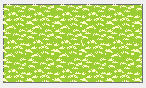
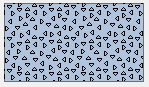
I wonder if it is possible to use my own polygon pattern for symbology on ArcGIS Online like points do. I have a set of standard pattern for land use, but they are not solid colors.
Ex:
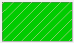
And when I tried to pre-set the symbology before publishing the service online, those came out empty (hollow with no color) or solid black instead. Like this:
Any idea please?
Thank you!
Emily
Solved! Go to Solution.
- Mark as New
- Bookmark
- Subscribe
- Mute
- Subscribe to RSS Feed
- Permalink
- Report Inappropriate Content
I am trying to update my Admin REST endpoint for the hosted feature layer but once I click on update service definition it gives me
error in updating as the picture below

- Mark as New
- Bookmark
- Subscribe
- Mute
- Subscribe to RSS Feed
- Permalink
- Report Inappropriate Content
Thanks for the solution to modify symbology of hosted Feature in ArcGIS Online.
I am trying to micmic a hatch symbol fill over a fill symbol fill (multi-layers symbol), as follow:

When shared to ArcGIS Online, only the first 2 layers displays. It looks like the plain yellow fill is not in the JSON file.
In drawingInfo for uniqueValue renderer, initially I have:
{"symbol":{"type":"esriSFS","style":"esriSFSBackwardDiagonal","color":[255,85,0,255],"outline":{"type":"esriSLS","style":"esriSLSSolid","color":[255,85,0,255],"width":0.5}},"value":"Sample","label":"Sample"}
And I am trying to add an extra “layer” in the symbology for the plain yellow fill:
"type":"esriSFSSolid","color":[255,255,153,255]
When updating the drawingInfo code, it gives:
{"symbol":{"type":"esriSFS","style":"esriSFSBackwardDiagonal","color":[255,85,0,255],"type":"esriSFSSolid","color":[255,255,153,255],"outline":{"type":"esriSLS","style":"esriSLSSolid","color":[255,85,0,255],"width":0.5}},"value":"Sample","label":"Sample"}
When hitting Update Service Definition button, it looks ok with a message “Updated Feature Service”… but when returning to the drawingInfo code, the changes do not appear.
I also tried to change the "lastEditDate" to null to validate the change, but it did not work either.
Finally, I noticed a message “Note: This operation is only supported via POST” in the top of the JSON page. Would it cause the drawingInfo not to update?
Any help appreciated
- Mark as New
- Bookmark
- Subscribe
- Mute
- Subscribe to RSS Feed
- Permalink
- Report Inappropriate Content
In addition to the JSON issue mentioned, is there a reason why the JSON do not show up in Portal?

It is strange! Same layer published to ArcGIS Online, JSON file is accessible, but not in Portal...
- Mark as New
- Bookmark
- Subscribe
- Mute
- Subscribe to RSS Feed
- Permalink
- Report Inappropriate Content
Hello. Your post really helps a lot of people. I thank you again! When I update the color RGBA and click the 'Update Service Definition' on the bottom, it doesn't update when I check the layer on webmap when adding it from the URL. When I go back to the Admin Update Service Definition page, the RGBA #s went back to original. Am I missing some step? Thank you.
- Mark as New
- Bookmark
- Subscribe
- Mute
- Subscribe to RSS Feed
- Permalink
- Report Inappropriate Content
You should be able to change the color in the drawingInfo section of the JSON, but I do not think there is anyway to change the width of the lines, or to overlay multiple line layers as you could do in ArcMap. For this sort of complex symbology you would have to publish a service through ArcServer not AGOL.
- Mark as New
- Bookmark
- Subscribe
- Mute
- Subscribe to RSS Feed
- Permalink
- Report Inappropriate Content
- « Previous
-
- 1
- 2
- Next »
- « Previous
-
- 1
- 2
- Next »