- Home
- :
- All Communities
- :
- Products
- :
- ArcGIS Online
- :
- ArcGIS Online Questions
- :
- Re: Arcade expression for Pop-Ups fails to display...
- Subscribe to RSS Feed
- Mark Topic as New
- Mark Topic as Read
- Float this Topic for Current User
- Bookmark
- Subscribe
- Mute
- Printer Friendly Page
Arcade expression for Pop-Ups fails to display.
- Mark as New
- Bookmark
- Subscribe
- Mute
- Subscribe to RSS Feed
- Permalink
- Report Inappropriate Content
Why won't the Attribute Expression configured for a Pop-Up save and display to a layer shared across Web Maps?
The following Arcade expression was a great work around for displaying the acres of a selected feature with the default Web Mercator Projection.


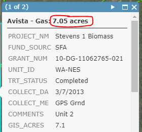
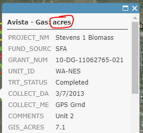
When the expression is added to the Pop-Up of a layer of a Hosted Feature Service shared with my work group it only works for one session in Map Viewer. When the Web Map is opened latter the expression output won't display. The expression still shows in the Pop-Up configuration menu, but it doesn't display an actual output in the Pop-Up.
The Feature Service and Web Maps in discussion are shared to a group and cached to Collector.
Any ideas on why the saved Arcade expression quits displaying?
Thanks,
Jcoo490
- Mark as New
- Bookmark
- Subscribe
- Mute
- Subscribe to RSS Feed
- Permalink
- Report Inappropriate Content
Hi Amy and Xander,
I read into this bug a little further. It looks like the bug is specific to using the AreaGeodetic expression with non-webmercator projection. Support is limited to geometries with a Web Mercator (wkid 3857) or a WGS 84 (wkid 4326) spatial reference.:
https://developers.arcgis.com/arcade/function-reference/geometry_functions/#areageodetic
It shouldn't have been possible to create this expression with a service in an unsupported geometry. Are you able to reproject your data into Web Mercator prior to publishing? This should get you up and running.
-Kelly
- Mark as New
- Bookmark
- Subscribe
- Mute
- Subscribe to RSS Feed
- Permalink
- Report Inappropriate Content
This has been a identified as a confirmed bug.
Based on Kelly's notes I started over from a new shapefile - in web mercator. Shared it as a hosted feature layer, enabled editor tracking. Created the expressions.
In the webmap I drew a new polygon. However the expressions wouldn't produce any values on this new hosted feature layer. Either way ESRI documents both as supported spatial references.
AreaGeodetic
AreaGeodetic( geometry, unit? ) -> returns:
NumberSince version 1.3
Returns the geodetic area of the input geometry in the given units. This is more reliable measurement of area than Area() because it takes into account the Earth's curvature. Support is limited to geometries with a Web Mercator (wkid 3857) or a WGS 84 (wkid 4326) spatial reference.
Be aware that using
$featureas input to this function will yield results only as precise as the view's scale resolution. Therefore values returned from expressions using this function may change after zooming between scales. Read more here.
Name Type Description geometry Polygon / Feature The Polygon or Extent geometry for which to calculate the planar area. unit String / Number optionalMeasurement unit of the return value. Use one of the string values listed in the Units reference or any of the numeric codes for area units.Returns:
NumberExample
Returns the geodetic area of the feature in square meters
AreaGeodetic($feature, 'square-meters')
I am desperate for a workaround solution for my organization to embrace ArcGIS Online for collaboration on shapes/spatial data . This is a key missing component for users. They need to be able to draw a polygon and get a very realistic size without using a secondary tool then editing to record the size.
Would the better approach be to create a JSON feature and return the JSON geometry calculation?
- Mark as New
- Bookmark
- Subscribe
- Mute
- Subscribe to RSS Feed
- Permalink
- Report Inappropriate Content
Are you able to share the layer that is published in Web Mercator? As this should be working with this projection I would recommend getting in contact with tech support if it isn't.
-Kelly
- Mark as New
- Bookmark
- Subscribe
- Mute
- Subscribe to RSS Feed
- Permalink
- Report Inappropriate Content
Kelly, I've already tried ESRI support. This has been a identified as a confirmed bug. See the note from the ESRI tech below.
Thank you for your reply. For the time being, I have attached the bug to the case, which you now should be able to see its full description in My ESRI > My Organization > Support > Search for the bug (BUG-000117230 - Arcade expressions Round(AreaGeodetic($feature, 'square kilometers'),2) is not saved when using 'Save Layer' option in the 'Visualization' tab of the item details)
I'm looking for a workaround.
I am desperate for a workaround solution for my organization to embrace ArcGIS Online for collaboration on shapes/spatial data . This is a key missing component for our users.
- Mark as New
- Bookmark
- Subscribe
- Mute
- Subscribe to RSS Feed
- Permalink
- Report Inappropriate Content
The BUG mentions that the Arcade expression is not stored when saving the layer, but why don't you share the web map instead?
- « Previous
-
- 1
- 2
- Next »
- « Previous
-
- 1
- 2
- Next »