- Home
- :
- All Communities
- :
- Products
- :
- ArcGIS Online
- :
- ArcGIS Online Ideas
- :
- "Add new unlisted values" for ArcGIS Online Webmap...
- Subscribe to RSS Feed
- Mark as New
- Mark as Read
- Bookmark
- Follow this Idea
- Printer Friendly Page
- Report Inappropriate Content
"Add new unlisted values" for ArcGIS Online Webmap Symbology
- Mark as New
- Bookmark
- Subscribe
- Mute
- Subscribe to RSS Feed
- Permalink
- Report Inappropriate Content
Problem:
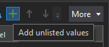
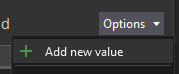
Data is often first loaded in to webmap with many possible unlisted values missing from the database. This is especially the case for fields with domains where certain values may not yet have been selected from the domain or when category values are populated based on dynamic calculations and change all the time. In ArcGIS Online webmaps when a user chooses to symbolise by category only existing values at that time will be symbolised. There is no "Add unlisted values > Add new values" option like in ArcGIS Pro such that the user can set up the symbology for all possible values.
Use case:
In flood management we have categories for flood levels which are autopopulated by a script based on telemetered data, for simplicity lets say Low, Medium, High, Extreme. At the moment all the river level stations are low but I need to build the webmap now. When I go to set up the symbology I can not find any way to add the Medium, High and Extreme values because there are none currently in the database. I know once these other values occur I could do this but I do not want to have to wait for and be setting up symbology for an extreme flood in the middle of an extreme flood.
Work-arounds:
1.) Add some fake test data - this is laborious and difficult if the layer is a map image and if all the data is auto generated. Fake records have to be deleted again.
2.) Load the webmap in to ArcGIS Pro and edit the symbology using the "Add unlisted values > Add new values" option and the save the webmap - Again this is laborious and have found this only works for feature layers, it does not appear to work for map image layers.
Solution:
From a user perspective it would be so much quicker and easier if there was an "Add unlisted values > Add new values" option, just like in ArcGIS Pro, when configuring symbology in an ArcGIS Online webmap. Don't know if this easy or hard to do but I'd imagine a lot of users out there would love to see it.
- Mark as Read
- Mark as New
- Bookmark
- Permalink
- Report Inappropriate Content
This concept would be incredibly useful across the platform in all applications (ArcMap, Pro, ArcGIS Online, JS API, etc)
Randomly assign a new color to a newly added attribute value, when symbology is set for categorical data and displaying as unique values. A new choropleth color could be randomly assigned; or even better, use an algorithm to make a color that fits in somewhat to the existing scheme (fits in but also contrasts).
Unique values symbology: add ability to set new unique colors randomly
- Mark as Read
- Mark as New
- Bookmark
- Permalink
- Report Inappropriate Content
What about an 'import symbology values from layer'-type option in AGOL, as we already have had in desktop for a long time. So we don't have to type/risk errors and can be consistent with the dataset/layer we published from.
You must be a registered user to add a comment. If you've already registered, sign in. Otherwise, register and sign in.