- Home
- :
- All Communities
- :
- Products
- :
- ArcGIS Online
- :
- ArcGIS Online Documents
- :
- Show Attachments in Web Map Popup
- Subscribe to RSS Feed
- Mark as New
- Mark as Read
- Bookmark
- Subscribe
- Printer Friendly Page
- Report Inappropriate Content
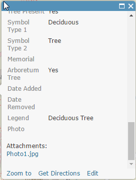
Show Attachments in Web Map Popup
Show Attachments in Web Map Popup
I work with a lot of customers that request the ability to display their feature service attachments in the web map's popup rather than a hyperlink. The attached script will convert the feature services attachments URL to a field. You can then display the attachment directly in the popup after some configuration.
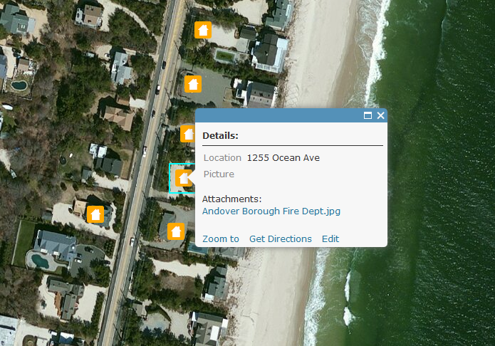
Here is a screen shot on how attachments display within a web map popup by default:
Below are the steps to show the attached image directly in the popup:
1. Add a TEXT/STRING field (i.e. "Picture") to the feature service that can support a large amount of characters (i.e. 1,000).
2. Execute the attached GP tool.
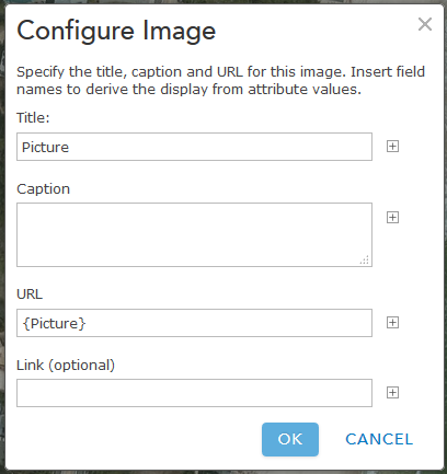
3. Configure the pop-up to Show Images. Ex:
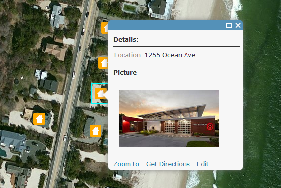
The image will now display directly in the popup. Ex:
Notes:
- the timeout for an ArcGIS Online feature service is set to the max of 15 days.
- the timeout for an ArcGIS Server service is set to the default 'Lifespan of long lived token'. The default is 1 day. This can be changed by going to Server Manager > Security > Settings. After the long lived token is updated, you can update the expiration parameter on line 33.
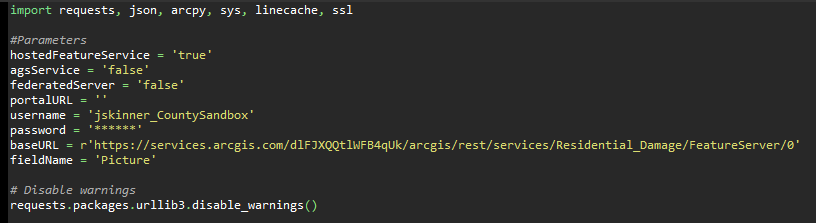
- Since the token will timeout, you can update the parameters in the script so this can be executed with Windows Task Scheduler. Here is an example of how to configure the parameters:
A video of the workflow can be found below:
- Mark as Read
- Mark as New
- Bookmark
- Permalink
- Report Inappropriate Content
Thanks Jake, this will be handy for one of my web maps that show the reports for the impaired waters and water bodies across the state. This could save us sometime on the back end.
- Mark as Read
- Mark as New
- Bookmark
- Permalink
- Report Inappropriate Content
How does this handle MULTIPLE attachments?
- Mark as Read
- Mark as New
- Bookmark
- Permalink
- Report Inappropriate Content
Currently, this code will only show the first attachment in the case where there are multiple.
- Mark as Read
- Mark as New
- Bookmark
- Permalink
- Report Inappropriate Content
Exactly what I'm in search for; however, I don't use ArcGIS Online so how do I get this to work in Portal for ArcGIS? I have gotten as far as replacing the baseURL to my feature service URL and Adding the "picture" field. Can someone advise on whatelse is required?
Thanks in advance,
Looking forward to hearing from you guys soon.
- Mark as Read
- Mark as New
- Bookmark
- Permalink
- Report Inappropriate Content
Any instructions for this to work in portal for Arcgis?
- Mark as Read
- Mark as New
- Bookmark
- Permalink
- Report Inappropriate Content
Can this be configured to work with services hosted on a ArcGIS server and not on AGOL?
Also does this need to be re-ran for each time or is it a one shot deal?
ie if i go out on multiple days and collect data would this have to be ran each day?
- Mark as Read
- Mark as New
- Bookmark
- Permalink
- Report Inappropriate Content
Randall,
I've been trying to get an answer to this debacle for the past two(2) weeks to no avail... Hopefully someone out there can provide some answers.
- Mark as Read
- Mark as New
- Bookmark
- Permalink
- Report Inappropriate Content
While I have only worked with AGO, it is my understanding that server would work much the same as AGO. You would be accessing the feature via the REST API. In the script that Jake attached, you would need to change username, password, baseURL, tokenURL, and referer in lines 4 through 6.
For example, baseURL would point to your servers REST point. Instead of pointing to "http :// services.arcgis.com /dlFJXQQUk /arcgis/rest/services/DamagedBuildings/FeatureServer/0" , change the "services.arcgis.com/dlFJXQQUk" to point to your server.
I would suggest looking at the REST API documentation for Server.
- Mark as Read
- Mark as New
- Bookmark
- Permalink
- Report Inappropriate Content
I might have a fix.
I posted this on a different forum and got a response but i have not tried it out yet. Im going to give a try today or tomorrow but here is link to the post and the response.
I also might try stackexchange
- Mark as Read
- Mark as New
- Bookmark
- Permalink
- Report Inappropriate Content
Hi Randy,
Thanks for responding and you are correct (i think)
Its really just a a matter of figuring out what the replacement values are which for a some of us that are new to this part of GIS, it can be hard to figure out where to start looking.
Hopefully that Intro to ArcGIS REST API class i am currently taking will help
- Mark as Read
- Mark as New
- Bookmark
- Permalink
- Report Inappropriate Content
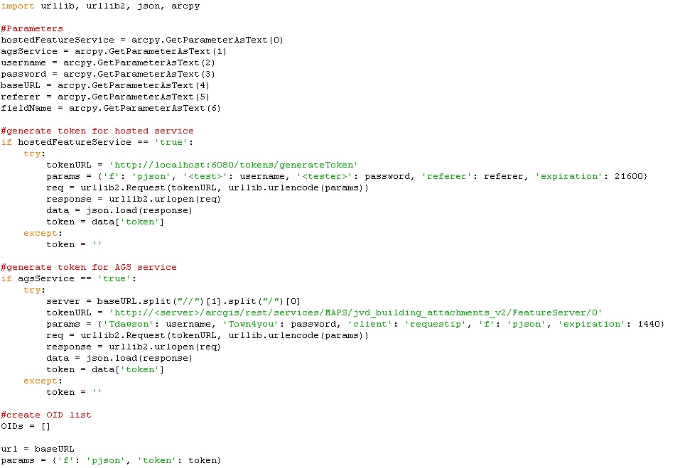
I haven't had a chance to look at this for ArcGIS Server, yet, but the code may work just by changing how the token is generated. For example, try the following:
tokenURL = 'http://' + server + '/arcgis/admin/generateToken'
params = {'username': username, 'password': password, 'client': 'requestip', 'f': 'pjson'}
req = urllib2.Request(tokenURL, urllib.urlencode(params))
response = urllib2.urlopen(req)
data = json.load(response)
token = data['token']
You will just need to replace 'server' with the name of the ArcGIS Server instance.
- Mark as Read
- Mark as New
- Bookmark
- Permalink
- Report Inappropriate Content
Updated the script to a GP tool that will update an ArcGIS Online feature service, or an ArcGIS Server feature service.
- Mark as Read
- Mark as New
- Bookmark
- Permalink
- Report Inappropriate Content
Could this tool be used for dynamic layers (e. g. collecting data with Collector for ArcGIS)? Or I have to repeat this tool everytime I update feature layer?
- Mark as Read
- Mark as New
- Bookmark
- Permalink
- Report Inappropriate Content
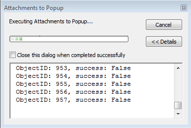
Great tool! Runs with no error but did not add URLs to the string field in the feature service, which I supplied to the script. The progress dialog indicates "success: False" for all records, yet most do have attachments and they are visible as links in the map.
- Mark as Read
- Mark as New
- Bookmark
- Permalink
- Report Inappropriate Content
Hi Neil,
Is it possible for you to share this feature service to a group and invite my user account (jskinner_CountySandbox)? I can try and download the service to see why the field is not updating.
- Mark as Read
- Mark as New
- Bookmark
- Permalink
- Report Inappropriate Content
Thanks. Invite sent.
- Mark as Read
- Mark as New
- Bookmark
- Permalink
- Report Inappropriate Content
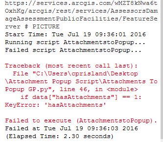
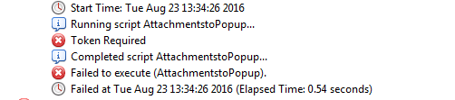
Thanks for the tool! Tried it with one of the services which have single attachments from agol. Even though the service has attacgments, the scripts gives error:
if data["hasAttachments"] == 1:
KeyError: 'hasAttachments'
Failed to execute (AttachmentstoPopup).
any ideas?
-Rupali
- Mark as Read
- Mark as New
- Bookmark
- Permalink
- Report Inappropriate Content
Neil, I was going to download the service using a tool I created, but in order to do that 'Sync' needs to be enabled. Can you enable this for the service?
- Mark as Read
- Mark as New
- Bookmark
- Permalink
- Report Inappropriate Content
Done. Thanks for taking a look.
- Mark as Read
- Mark as New
- Bookmark
- Permalink
- Report Inappropriate Content
Greetings All,
I have attached the original python file provided in the above downloadable zip file and also my edited version of the python file. I have NOT been able to get this GP tool working with ArcGIS Server. Can someone please advise as to what other changes are required to the script in order to get this tool working.
Thank in advance
Original

Edited Version
- Mark as Read
- Mark as New
- Bookmark
- Permalink
- Report Inappropriate Content
Did you get this to work on ArcServer? I have followed along but continue to get a line 41 error token not defined.
- Mark as Read
- Mark as New
- Bookmark
- Permalink
- Report Inappropriate Content
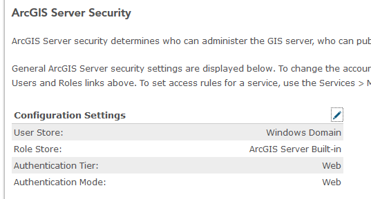
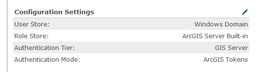
Hi Hunter,
Is the ArcGIS Server service secure? Also, what type of authentication are you using for your ArcGIS Server security?
I noticed that if you have web tier authentication and the service is not secured, you will still have to specify a username/password.
Ex of web tier authentication:
- Mark as Read
- Mark as New
- Bookmark
- Permalink
- Report Inappropriate Content
Hi Troy,
What error are you receiving when you use this tool with an ArcGIS Server service?
- Mark as Read
- Mark as New
- Bookmark
- Permalink
- Report Inappropriate Content
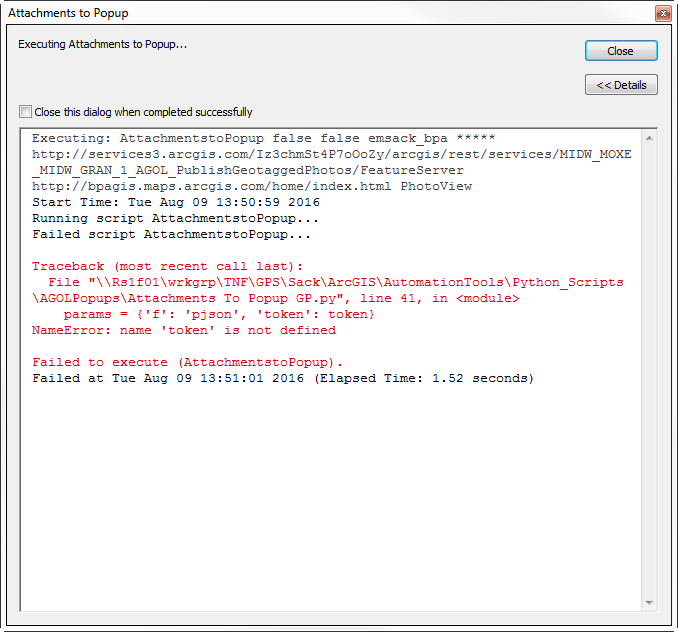
Jake, Thanks for the quick reply
I was able to move past the line 41 error by switching the token endpoint from my web adapter URL to the Port number URL.
I am now getting hung up on line 46
if data["hasAttachments"] == 1:
KeyError: 'hasAttachments'
Failed to execute (AttachmentstoPopup).
Trying to get a bunch of pictures generated from a collector app moved to a pop up for AGOL and then formatted in a report for water quality reporting.
- Mark as Read
- Mark as New
- Bookmark
- Permalink
- Report Inappropriate Content
Hi Hunter,
What type of security do you have implemented for ArcGIS Server? Is the service itself secure?
If you'd like, you can share the service URL to a Group on ArcGIS Online, and then invite my username (jskinner_CountySandbox) to that group. I can then view the service and take a look at what's going on.
- Mark as Read
- Mark as New
- Bookmark
- Permalink
- Report Inappropriate Content
Jake,
Thanks I just sent you a invite to the service. The service is secure, however I shared it on AGOL to you with credentials attached.
- Mark as Read
- Mark as New
- Bookmark
- Permalink
- Report Inappropriate Content
THAT WAS SO EASY! Thank you so much!
- Mark as Read
- Mark as New
- Bookmark
- Permalink
- Report Inappropriate Content
Jake,
This is a great script and I can see several benefits of using it. However, when I trying running it against an AGO feature service, I get the following error. All features have an attachment tied to them. Any assistance would be greatly appreciated. Thanks in advance!
- Mark as Read
- Mark as New
- Bookmark
- Permalink
- Report Inappropriate Content
I would have to take a look at the service to see what's going on. You can share the service to a Group and invite my AGOL user, jskinner_CountySandbox, to this group if you'd like.
- Mark as Read
- Mark as New
- Bookmark
- Permalink
- Report Inappropriate Content
Invite sent. Thanks again for taking a look at this. Just a heads up, you will notice that there are several layers in this feature service. These are all referencing the same data but need certain fields turned on/off depending on CAT selected.
Thanks.
- Mark as Read
- Mark as New
- Bookmark
- Permalink
- Report Inappropriate Content
Hey Jake - any chance I can send you an invite to take a look at service in AGOL I am having trouble getting this tool to run on? I'm getting stuck at line 41.
- Mark as Read
- Mark as New
- Bookmark
- Permalink
- Report Inappropriate Content
Hi Eric,
Sure, my username is jskinner_CountySandbox. Also, please make sure 'Sync' is enabled on the service.
- Mark as Read
- Mark as New
- Bookmark
- Permalink
- Report Inappropriate Content
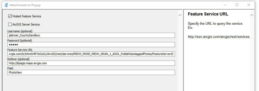
All set Jake; invite sent- sync was already enabled.
Thanks in advance for your time- the feature service I am trying is called 'Geotagged Photos for Midway-Moxee No 1 and Midway-Grandview No 1 2016' :
http://services3.arcgis.com/Iz3chmSt4P7oOoZy/arcgis/rest/services/MIDW_MOXE_MIDW_GRAN_1_AGOL_PublishGeotaggedPhotos/FeatureServer
The field is called ‘GeoTaggedPhoto’.
Eric Sack/GISP
ACS
Geographer III | Civil Design – TELF
Bonneville Power Administration
bpa.gov<http://www.bpa.gov/> | P 360-619-6359 | C 503-957-6734
- Mark as Read
- Mark as New
- Bookmark
- Permalink
- Report Inappropriate Content
One other question, what is the referer to your ArcGIS Online Organization?
- Mark as Read
- Mark as New
- Bookmark
- Permalink
- Report Inappropriate Content
I wasn’t sure what that was – is it our Organizational URL?
http://bpagis.maps.arcgis.com/home/index.html
Eric-
- Mark as Read
- Mark as New
- Bookmark
- Permalink
- Report Inappropriate Content
Eric,
It doesn't look like the GeoTaggedPhoto field length is large enough. I downloaded the service using the following tool, changed the field length to 700, and then re-uploaded to ArcGIS Online. I was then able to successfully run the Attachments to Popup tool.
- Mark as Read
- Mark as New
- Bookmark
- Permalink
- Report Inappropriate Content
Ah – thanks Jake; I created a new one called PhotoView with 700 field length but still get this error and how I have the tool populated.
Eric-
- Mark as Read
- Mark as New
- Bookmark
- Permalink
- Report Inappropriate Content
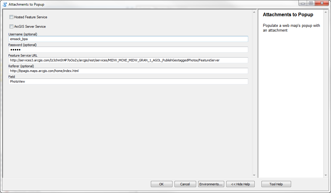
Hi Eric,
I see a few errors in how the tool is set up:
1. You will want to check 'Hosted Feature Service' since you are updating a hosted feature service
2. The Feature Service URL should reference the index (i.e add /0 at the end of the URL) of the layer you are updating. Ex:
Notice the '/0' at the end of the URL.
3. The referrer should just be the following (I need to update the help on this):
I went ahead and ran the tool:
I also created a web map:
If you click on a feature you will see the image directly in the popup.
- Mark as Read
- Mark as New
- Bookmark
- Permalink
- Report Inappropriate Content
Jake - thanks again for your time; it works great! I was able to configure the pop-up in my web map and am all set.
Best regards-
Eric-
- Mark as Read
- Mark as New
- Bookmark
- Permalink
- Report Inappropriate Content
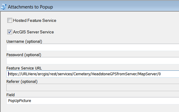
Hi there,
I have tried to running the GP script with the following configuration:
- ArcGIS Server Service
- included ArcGIS Server Login and password
- provided a feature Service URL with service index url provided (.../0 etc.)
- Define the field that I want to updated (although i'm not sure how it would know which featureclass to update within my MXD)
I have also ensure that my long-lived tokens is set to more than one day

However this is the result below:
Any help will be greatly appreciated!
- Mark as Read
- Mark as New
- Bookmark
- Permalink
- Report Inappropriate Content
bob_says48, can you attach a screen shot of how you have the tool setup?
- Mark as Read
- Mark as New
- Bookmark
- Permalink
- Report Inappropriate Content
This is the error i encountered using the same configuration as seen above.
Thanks in advance,
- Mark as Read
- Mark as New
- Bookmark
- Permalink
- Report Inappropriate Content
What is your 'esriFieldTypeOID' set to? It appears to be error on this. You can find this out by viewing the service through your REST Services Directory:

- Mark as Read
- Mark as New
- Bookmark
- Permalink
- Report Inappropriate Content

- Mark as Read
- Mark as New
- Bookmark
- Permalink
- Report Inappropriate Content
I would need to take a look at the service to see what's going on. Anyway to disable the security and send me a private message with REST URL? Also, you will want to delete the GP error in your previous post. It contains the REST URL you are using.
- Mark as Read
- Mark as New
- Bookmark
- Permalink
- Report Inappropriate Content
Hi Jake,
PM Sent, looking forward to hear your thoughts on it 😃
- Mark as Read
- Mark as New
- Bookmark
- Permalink
- Report Inappropriate Content
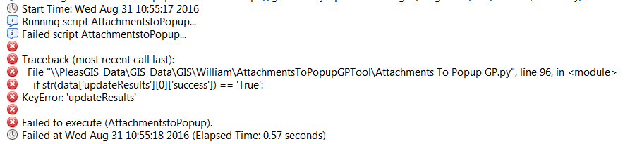
Hi Jake,
New to python...
Should I have changed the script on line 96?
Attached is my setup and updateResults error.
- Mark as Read
- Mark as New
- Bookmark
- Permalink
- Report Inappropriate Content
Hi William,
You will need to change your URL. You are currently referencing the Map Service. You will want to reference the Feature Service. i.e.:
https://URHHere/arcgis/rest/services/Cemetery/HeadstoneGPSfromServer/FeatureServer/0
- Mark as Read
- Mark as New
- Bookmark
- Permalink
- Report Inappropriate Content
Jake - Thank you!!! For both the script and quick respond. It worked
My apology for not reading your post carefully.
- Mark as Read
- Mark as New
- Bookmark
- Permalink
- Report Inappropriate Content
please can any body help me with what I need to do when receiving the error below
thank you in advance and also a big thanks to the creator of the tool.
