- Home
- :
- All Communities
- :
- Products
- :
- ArcGIS Network Analyst
- :
- ArcGIS Network Analyst Questions
- :
- Vehicle Routing Problem: Flexible Route Amounts an...
- Subscribe to RSS Feed
- Mark Topic as New
- Mark Topic as Read
- Float this Topic for Current User
- Bookmark
- Subscribe
- Mute
- Printer Friendly Page
Vehicle Routing Problem: Flexible Route Amounts and Depot Assignments?
- Mark as New
- Bookmark
- Subscribe
- Mute
- Subscribe to RSS Feed
- Permalink
- Report Inappropriate Content
I've only ever used Network Analyst for simple things like Route Solver. I have a more difficult task this time.
Task: I have a large maze-like network of hiking trails for which I need to walk along all of them and update centerlines, conditions, etc. There are so many and the network so complex, that I think it is worth the effort to plan out my routes rather than just wing it and more than likely waste a lot of time and effort in backtracking and filling in missed spots. I think a Vehicle Routing Problem is the best way to go about finding those ideal routes.
Data:
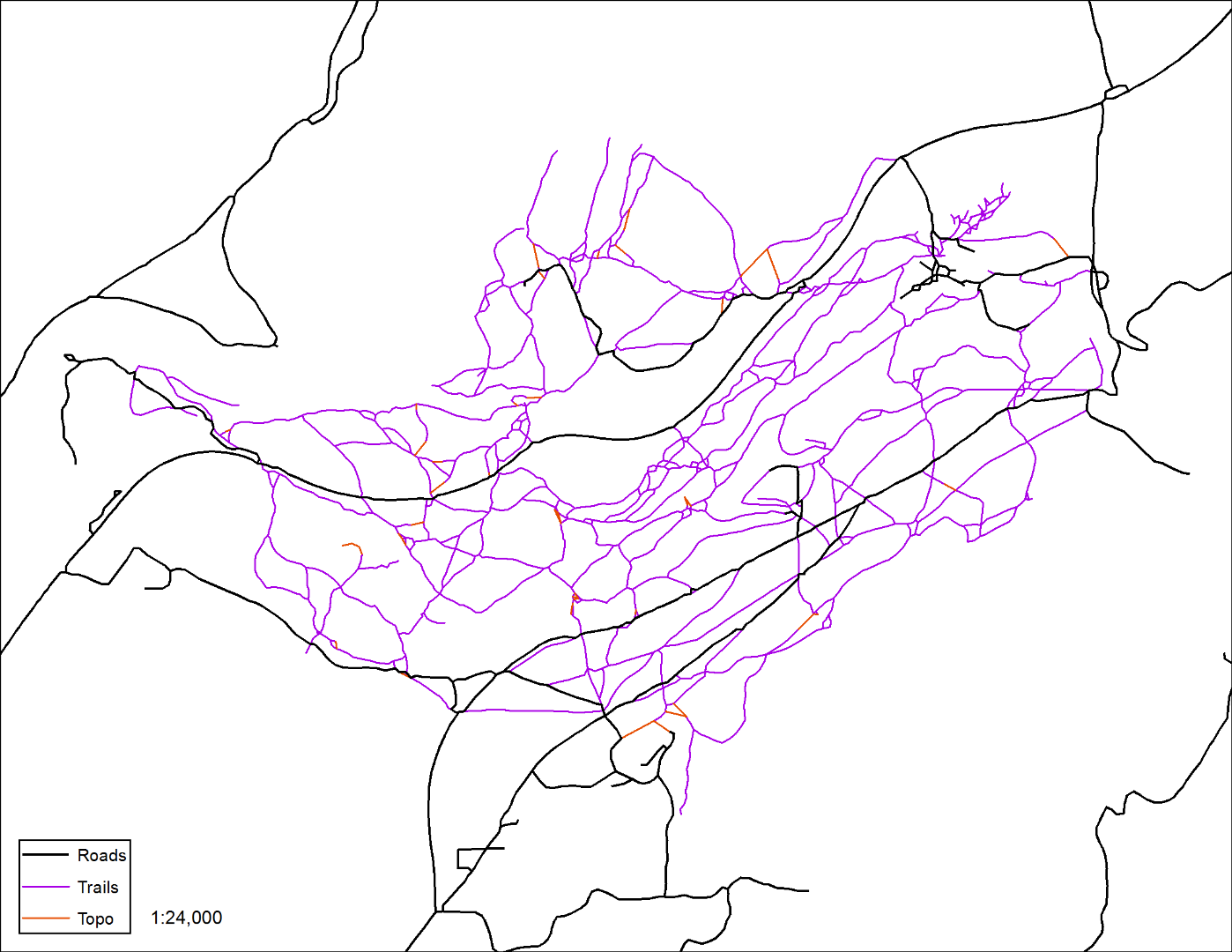
Roads.shp: These are polylines of all accessible roads. I want to start and end my routes from them.
Trails.shp: In this file are the trails I have to traverse.
Add'l Data:
Trails_Topo: 'Trails' edited to be topologically useful, more or less. No overlaps or gaps, those kinds of things. (The red parts in the picture are extensions to make the topology better or where I believe trails may be but are just not in the original data.)
Roads_Topo: 'Roads' edited in a similar fashion.
Combo_Topo: Trails and Roads combined and then edited to be topologically related or whatever to each other.
Intersections: Points where 'Trails' intersects 'Roads'
Inters_Topo: Points where 'Trails_Topo' intersects 'Roads_Topo'
Study_Line: Line that surrounds the study area to restrict the NA from routing to trails I am not interested in.
Study_Poly: Polygon that creates a 'Doughnut" around the study area, for the same reason as ^
Trails_Pt: Points along 'Trails' created by Points-from-Vertices tool.
Parameters:
-Starts and ends of routes: Parking and returning to there at the end of the route is possible, but likely to be inefficient in most cases. If possible, I would like to tell NA that Crew#1 can be dropped anywhere on 'Roads', but Crew#1 must end their route where Crew#2 leaves it (starts their route) if Crew#2 is not going to end where it began, and Crew#2 must end their route along a road so that when Crew#1 retrieves that car, they can pick Crew#2 up.
-Since it is impossible to give these trails individual time costs/distance, I instead would like to tell NA that no route should exceed ___km/mi total distance. If possible, I would like to give 3 or 4 maximum route lengths and compare how that changes the analysis. (Discontinuous routes are probably not possible to include in Network Analyst but that's probably not going to be a problem given the shape of this particular network of trails/roads.)
-I have no limit on the total number of routes. Minimizing them is something that NA will probably do by default, but how can I be sure?
-Routes CAN overlap/double-up but do not have to.
Problems:
1. I cannot see a way to tell NA, "I need to travel on all these lines. These other lines MAY be used as shortcuts or whatever as needed". All I can see is how to make lines and polygons that the VRP won't go over/through, which is fine for my Study Area things, but not so much for finding efficient routes. I also cannot assign lines as 'Orders' as the VRP wants destinations to exist as. I worked around this by using Points-from-Vertices for my trails and input all those ~2500 points as orders.
2. I could not figure out how to tell one route to begin or end at the yet-to-be-determined start/end depot of another route, if this is even possible.
3. This is also my first time seriously using Topology to clean up data and get it into a condition where the Network Analyst can comfortably operate.
Any help or advice you all can offer would be helpful and greatly appreciated.