- Home
- :
- All Communities
- :
- Products
- :
- ArcGIS Network Analyst
- :
- ArcGIS Network Analyst Questions
- :
- summing the pedestrians who pass through every roa...
- Subscribe to RSS Feed
- Mark Topic as New
- Mark Topic as Read
- Float this Topic for Current User
- Bookmark
- Subscribe
- Mute
- Printer Friendly Page
summing the pedestrians who pass through every road
- Mark as New
- Bookmark
- Subscribe
- Mute
- Subscribe to RSS Feed
- Permalink
- Report Inappropriate Content
Hi
I was wondering if someone could help me with a network / routing challenge.
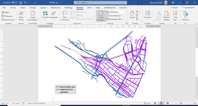
The main aim of this task is to estimate the flow of pedestrians/ people who move on the road network from their start locations toward a final destination. The origins is a points layer where every point includes a field that counts the number of people who live in that point location. Further, we have the destination point (another points layer) where all these people will travel to via a road network layer. Using the closest facility tool with the road network dataset ,origins and destination we could obtain the closest route from every origin to the destination as can be seen below:
After obtaining the closest facility above, we did an intersection between the original network (dark blue network) and the closest facility route (Purple network) to find how many times every segment has been traversed by every point. However, this method assume that every origin point has the same number of people which is not true. Every point has different number of people who live in that location/origin. So instead of calculating the number of times every road has been passed by every route, we need to calculate how many people/pedestrians who passed every road towards the destination. As the closest facility route table result does not contain the number of people who are occupied in every point, I am thinking that there is a way ( within Arc GIS) which can calculate the number of people who pass via every road. Personally , I think there is some way to calculate it within the closest facility to know how many people has traversed via every road. Any idea how to do it please
