Turn on suggestions
Auto-suggest helps you quickly narrow down your search results by suggesting possible matches as you type.
Cancel
- Home
- :
- All Communities
- :
- Products
- :
- ArcGIS Network Analyst
- :
- ArcGIS Network Analyst Questions
- :
- Put Stop identity in directions (instead of callin...
Options
- Subscribe to RSS Feed
- Mark Topic as New
- Mark Topic as Read
- Float this Topic for Current User
- Bookmark
- Subscribe
- Mute
- Printer Friendly Page
Put Stop identity in directions (instead of calling it location1)
Subscribe
1595
2
10-16-2012 01:34 AM
10-16-2012
01:34 AM
- Mark as New
- Bookmark
- Subscribe
- Mute
- Subscribe to RSS Feed
- Permalink
- Report Inappropriate Content
Hello,
I built a network dataset and am using it in a WPF application through arcgis server. I have a Directions window that lists the directions for driving through the route that was calculated.
My problem is:
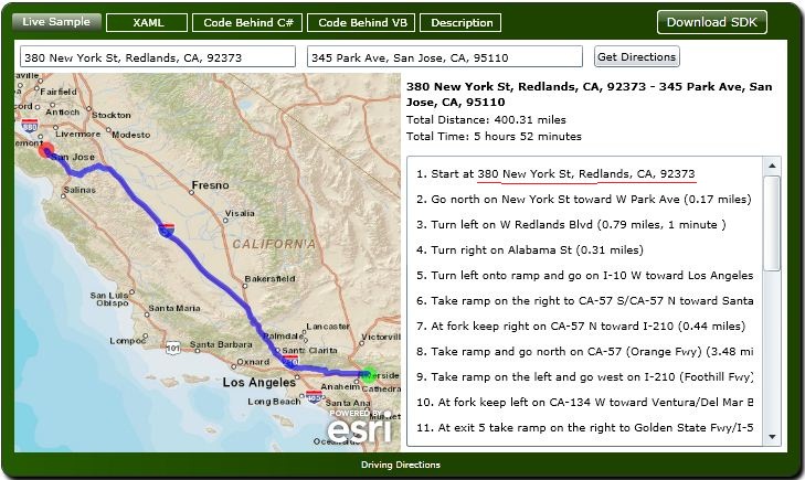
The directions refer to the stops as "location1", "location2" and so on. I saw in the online API that the stops are referred to as the addresses themselves (Look in the the attachment - underlined in red). How can I mimic this?
Thanks.
I built a network dataset and am using it in a WPF application through arcgis server. I have a Directions window that lists the directions for driving through the route that was calculated.
My problem is:
The directions refer to the stops as "location1", "location2" and so on. I saw in the online API that the stops are referred to as the addresses themselves (Look in the the attachment - underlined in red). How can I mimic this?
Thanks.
2 Replies
10-17-2012
11:57 PM
- Mark as New
- Bookmark
- Subscribe
- Mute
- Subscribe to RSS Feed
- Permalink
- Report Inappropriate Content
Hi, when you add locations to the Stops sublayer of the Route layer, you can specify which value/field will be used for the Name. The Name field is used then in the Directions window (of course you can choose what field to use in the Directions).
I believe there should be an individual property for the Stops class where you can programmatically add the value user entered (and the one that is used for geocoding).
Stops properties from the Network Analyst help.
I believe there should be an individual property for the Stops class where you can programmatically add the value user entered (and the one that is used for geocoding).
Stops properties from the Network Analyst help.
10-23-2012
01:01 AM
- Mark as New
- Bookmark
- Subscribe
- Mute
- Subscribe to RSS Feed
- Permalink
- Report Inappropriate Content
Thanks, tereshenkov. Here is the code I used in the end:
GraphicsLayer stopsGraphicsLayer = myMap.Layers["myStops"] as GraphicsLayer;
Graphic stop = new Graphic() [Geometry = e.MapPoint };
ESRI.ArcGIS.Client.Geometry.Geometry whats = stop.Geometry;