- Home
- :
- All Communities
- :
- Products
- :
- ArcGIS Network Analyst
- :
- ArcGIS Network Analyst Questions
- :
- Connect segments with different elevation values
- Subscribe to RSS Feed
- Mark Topic as New
- Mark Topic as Read
- Float this Topic for Current User
- Bookmark
- Subscribe
- Mute
- Printer Friendly Page
Connect segments with different elevation values
- Mark as New
- Bookmark
- Subscribe
- Mute
- Subscribe to RSS Feed
- Permalink
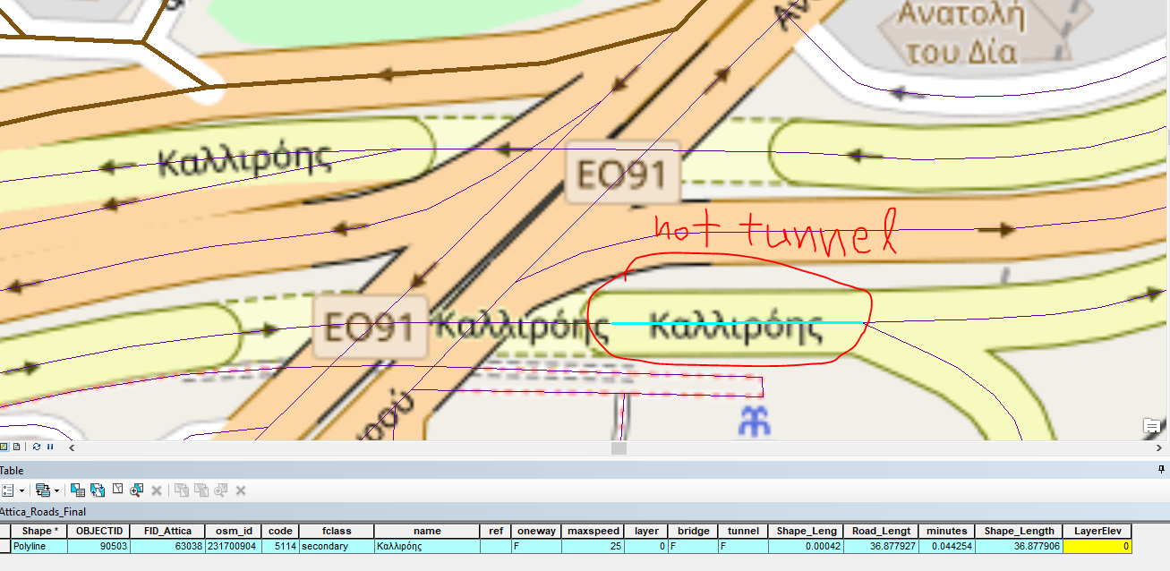
I am using ArcGIS 10.4.1 and Network Analyst. I am facing an issue when trying to connect segments with different elevation values. In the image below we can see a segment of a tunnel and its attribute table. It has a a value of -1 for LayerElev field(field marked yellow).
But the next segment is not a tunnel so it has a a value of 0 for LayerElev field(field marked yellow).
What is the proper way to connect those to segments? Do i have to create 2 fields in the attribute table (from endpoint and to endpoint) instead of the one i 've got now?
I have to use elevation because the area has complicated junctions with overpasses, underpasses and tunnels.
Solved! Go to Solution.
Accepted Solutions
- Mark as New
- Bookmark
- Subscribe
- Mute
- Subscribe to RSS Feed
- Permalink
Probably the easiest way to do this is with an elevation field and a network dataset design set to use elevation connectivity. Note that you will have to rebuild your network dataset to accommodate this change.
"The elevation field model can be used to enhance the connectivity of the network, if there is elevation field data available."
Designing the network dataset—Help | ArcGIS Desktop
Here is the specific field information you will need to incorporate and populate:
"If your data uses z-elevation or z-level values to model overpasses and underpasses, be sure this information is stored in a pair of integer fields—one field for each end of the edge. If the fields are named either F_ELEV and T_ELEV or F_ZLEV and T_ZLEV, the New Network Dataset wizard automatically detects these fields."
Creating a network dataset—Help | ArcGIS Desktop
See also the section called "Modelling elevation" in this link:
Understanding connectivity—Help | ArcGIS Desktop
Chris Donohue, GISP
- Mark as New
- Bookmark
- Subscribe
- Mute
- Subscribe to RSS Feed
- Permalink
Yes, generally when working with elevation fields, you should have two separate fields. One represents the elevation value at the "From" end of the line, and the other represents the elevation value at the "To" end of the line. This makes it possible to transition between levels, like a ramp.
Note that if you are editing street data in ArcGIS Pro instead of ArcMap, the elevation fields are managed for you in a way that ensures connectivity.
- Mark as New
- Bookmark
- Subscribe
- Mute
- Subscribe to RSS Feed
- Permalink
Probably the easiest way to do this is with an elevation field and a network dataset design set to use elevation connectivity. Note that you will have to rebuild your network dataset to accommodate this change.
"The elevation field model can be used to enhance the connectivity of the network, if there is elevation field data available."
Designing the network dataset—Help | ArcGIS Desktop
Here is the specific field information you will need to incorporate and populate:
"If your data uses z-elevation or z-level values to model overpasses and underpasses, be sure this information is stored in a pair of integer fields—one field for each end of the edge. If the fields are named either F_ELEV and T_ELEV or F_ZLEV and T_ZLEV, the New Network Dataset wizard automatically detects these fields."
Creating a network dataset—Help | ArcGIS Desktop
See also the section called "Modelling elevation" in this link:
Understanding connectivity—Help | ArcGIS Desktop
Chris Donohue, GISP