Turn on suggestions
Auto-suggest helps you quickly narrow down your search results by suggesting possible matches as you type.
Cancel
- Home
- :
- All Communities
- :
- Products
- :
- ArcGIS Network Analyst
- :
- ArcGIS Network Analyst Questions
- :
- 3D Routing Issues with Line Elevations Interpolate...
Options
- Subscribe to RSS Feed
- Mark Topic as New
- Mark Topic as Read
- Float this Topic for Current User
- Bookmark
- Subscribe
- Mute
- Printer Friendly Page
3D Routing Issues with Line Elevations Interpolated from DEM
Subscribe
1569
2
07-08-2011 11:09 AM
07-08-2011
11:09 AM
- Mark as New
- Bookmark
- Subscribe
- Mute
- Subscribe to RSS Feed
- Permalink
- Report Inappropriate Content
I am attempting to use two separate line feature classes to create a walking network that includes internal and external pathways. I have successfully combined these two using false elevations, but I am now trying to use real-world elevations.
I used the "Interpolate Shape" and a Lidar DEM to get the elevations for the external pathways. I then created points for the endpoints of those lines and derived the Z values for each of those points. I used the Z values from these points as the elevations for the connecting points of the internal network. I created To_Elev and From_Elev fields and then created a 3D feature by use of the "Feature to 3D by Attribute".
The problem I am running into is that with my false elevations, not derived from a DEM, the internal to external routing works fine. However, when I attempt to route with the network that has elevations derived from the DEM, the stops will be placed successfully on the internal paths, but the route will solve on primarily the external paths that are closest to the stops placed on the internal paths.
At first I thought there was a problem with my model when running the analysis in ArcScene, but the same problem is occurring when I run the solver in ArcMap.
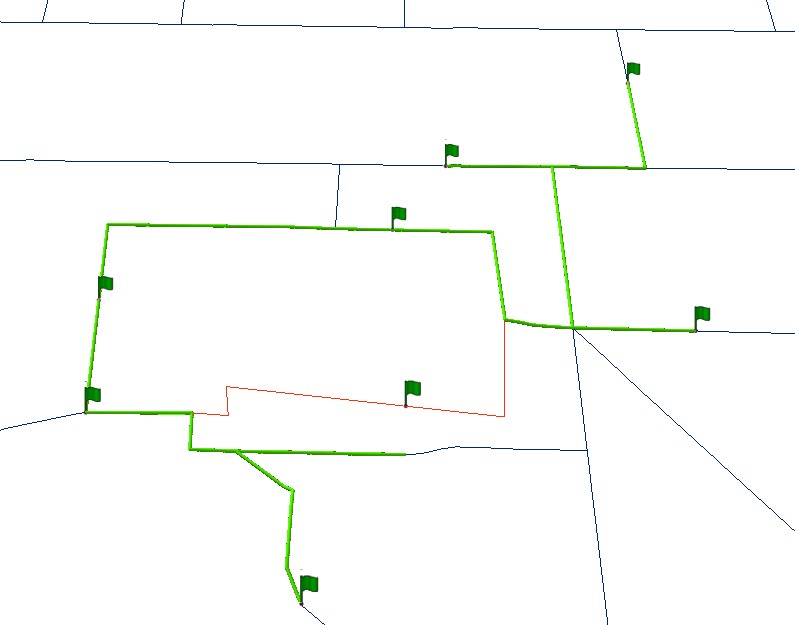
I am attaching a screen shot of the issue. The "internal" paths is a simplified test line that I made and is in red. The external paths are navy, and the route features are purple.
I used the "Interpolate Shape" and a Lidar DEM to get the elevations for the external pathways. I then created points for the endpoints of those lines and derived the Z values for each of those points. I used the Z values from these points as the elevations for the connecting points of the internal network. I created To_Elev and From_Elev fields and then created a 3D feature by use of the "Feature to 3D by Attribute".
The problem I am running into is that with my false elevations, not derived from a DEM, the internal to external routing works fine. However, when I attempt to route with the network that has elevations derived from the DEM, the stops will be placed successfully on the internal paths, but the route will solve on primarily the external paths that are closest to the stops placed on the internal paths.
At first I thought there was a problem with my model when running the analysis in ArcScene, but the same problem is occurring when I run the solver in ArcMap.
I am attaching a screen shot of the issue. The "internal" paths is a simplified test line that I made and is in red. The external paths are navy, and the route features are purple.
2 Replies
07-09-2011
09:11 AM
- Mark as New
- Bookmark
- Subscribe
- Mute
- Subscribe to RSS Feed
- Permalink
- Report Inappropriate Content
How are you placing the stops? Are you clicking on the map? Note that ArcMap is a 2-d application and can only return 2-d points. if that is your work flow, I would suggest that you create 3-d points and use Load Locations to load them and they should snap on to the correct locations.
Jay Sandhu
Jay Sandhu
07-09-2011
11:21 AM
- Mark as New
- Bookmark
- Subscribe
- Mute
- Subscribe to RSS Feed
- Permalink
- Report Inappropriate Content
Yes, I was placing them interactively. I created a 3D point class and snapped them to the network in ArcScene, loaded the stops from it and it appears to be working a little better. However it still will occasionally successfully locate the stops yet not actually route through them.
I have attached two photos from ArcScene, one showing a route that goes through most stops and one where four of the successfully located stops are ignored by the route.
I have attached two photos from ArcScene, one showing a route that goes through most stops and one where four of the successfully located stops are ignored by the route.