- Home
- :
- All Communities
- :
- Products
- :
- ArcGIS Maritime
- :
- ArcGIS Maritime Questions
- :
- Chart Automation
- Subscribe to RSS Feed
- Mark Topic as New
- Mark Topic as Read
- Float this Topic for Current User
- Bookmark
- Subscribe
- Mute
- Printer Friendly Page
Chart Automation
- Mark as New
- Bookmark
- Subscribe
- Mute
- Subscribe to RSS Feed
- Permalink
Hello everyone!
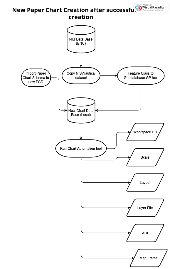
I have a question regarding Paper Chart Creation using Chart Automation tool. Please see below workflow I did to understand main steps I should follow to create Paper Chart.
My Questions:
Q1. Do I need to create fresh FGD for local Paper Chart and import to it Paper Chart Schema?
Q2. After creating FGD for Chart can I import all Nautical datasets from NIS database for ENC using Feature Class to Geodatabase tool? Or c=should I use other tool for copying?
Q3. Do I need to copy Product Coverages polygon and Product Definitions relations together from NIS (ENC)?
I tried to follow these steps shown in Workflow Diagram but I got an error when I tried to run Chart Automation tool it said something like this features already exists.
If required I can create short video demonstration of error with all steps I took to replicate the error I am getting.
Thank you in advance for your assistance with troubleshooting my problem!
With respect,
Naur
- Mark as New
- Bookmark
- Subscribe
- Mute
- Subscribe to RSS Feed
- Permalink
Do I need to use "Copy S-57 Features" tool to copy Nautical datasets to new Paper Chart Database?

- Mark as New
- Bookmark
- Subscribe
- Mute
- Subscribe to RSS Feed
- Permalink
Hello @NauryzbekAbylkair ,
If you are expecting to maintain your paper chart products after the initial creation, I recommend establishing a one-way replica from your NIS. This workflow applies if your NIS is in an enterprise geodatabase.
Create a paper chart schema in an empty file geodatabase. See: Create an S-57 or Paper Chart database)
Establish a one-way replica from the NIS to your paper chart file geodatabase - this includes copying the data. Make sure to include the PLTS_FREL and PLTS_COLLECTIONS tables in the replica definition. See: Create a one-way replica
Run CAT on your paper chart product geodatabase. See: Automate chart finishing.
- Next time you make data updates in your NIS, synchronize your paper chart product database using the Synchronize Changes tool.
If your NIS is in a file geodatabase, you can use the Copy S-57 Features tool to copy data to your paper chart product database. The tool respects selection, so you can select the features that intersect the paper chart product AOI before running the tool.
Q3. Do I need to copy Product Coverages polygon and Product Definitions relations together from NIS (ENC)?
You don't need to copy the product feature classes and tables.
Hope this helps,
Paulina
- Mark as New
- Bookmark
- Subscribe
- Mute
- Subscribe to RSS Feed
- Permalink
@PaulinaKarkauskaite Thank you so much for your detailed Instructions!
I have problem with my Layout after running Chart Automation tool.
- New Project
- Imported Paper Chart schema to the default project DB
- Imported S-57 cell (.000 file) to Project DB (used Import S57 to Geodatabase tool)
- Created a Blank Layout without any styles or elements, just a plain A0 layout.
- Added Mar Frame (I assume Map Frame's CRS shall be WGS84 in Mercator Projection)
- Why is my Layout size 179 x 338 mm after running CAT while I chose 841 x 1189 as a standard A0 paper format for Layout?
- Should I change something in configuration or Environment to get required layout size?
I tried to change it but it didn't work out.
Version of software: ArcGIS Pro ver 3.4.3
- Mark as New
- Bookmark
- Subscribe
- Mute
- Subscribe to RSS Feed
- Permalink
@NauryzbekAbylkair the annotation in your screenshot represents the length of the bottom and right grid segments.

See: Annotation styles for grids
Your layout page size stays the same after running CAT.
Let me know if you have additional questions on this. 🙂
Thanks,
Paulina
- Mark as New
- Bookmark
- Subscribe
- Mute
- Subscribe to RSS Feed
- Permalink
@PaulinaKarkauskaite Thank you very much for your help with solution! I am a bit confused that the documentation for ArcMap but I am using ArcGIS Pro v 3.4.3. As far as I concerned ArcGIS Pro doesn't use Annotation elements and heavily rely on Python Labeling Expressions.
How can I change settings in the ArcGIS Pro to make it work for A0 paper format while I am running CAT?
Thanks,
Nauryzbek
- Mark as New
- Bookmark
- Subscribe
- Mute
- Subscribe to RSS Feed
- Permalink
@NauryzbekAbylkair The annotation you are seeing is coming from the grid definition xml template. This template was originally designed in the Grids And Graticules designer, in ArcMap, that is why the documentation comes from ArcMap.
In ArcGIS Pro, CAT is calling the Make Grids And Graticules Layer tool to generate the grids. The annotation in the lower right corner of the panel is showing the grid dimensions, not the page size/paper size. So your page size is still A0. 🙂
CAT is not changing the page size. If you want to check or change your page size, you can do that in the Layout Properties > Page Setup. See: Change a layout

Thanks,
Paulina