- Home
- :
- All Communities
- :
- Products
- :
- Mapping and Charting Solutions
- :
- Mapping and Charting Questions
- :
- How to create airway label for Enroute chart
- Subscribe to RSS Feed
- Mark Topic as New
- Mark Topic as Read
- Float this Topic for Current User
- Bookmark
- Subscribe
- Mute
- Printer Friendly Page
How to create airway label for Enroute chart
- Mark as New
- Bookmark
- Subscribe
- Mute
- Subscribe to RSS Feed
- Permalink
- Report Inappropriate Content
Hi!
I have some problem about create a complex label for airway in Enroute chart.
I want to create label like this one.
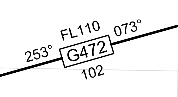 Each data come from different field in same shapefile.
How can I create label like this?
I use ArcGIS 10.3.1.
Thank you.
- Mark as New
- Bookmark
- Subscribe
- Mute
- Subscribe to RSS Feed
- Permalink
- Report Inappropriate Content
Hi Alongkorn,
Do you have ArcGIS for Aviation: Charting? If so, is your data in a geodatabase within the AIS data model?
You mention 'shapefile'.
- Mark as New
- Bookmark
- Subscribe
- Mute
- Subscribe to RSS Feed
- Permalink
- Report Inappropriate Content
Hi David,
Thank you for your answer and yes, I do have a ArcGIS for Aviation: Charting license (version 10.3.1). Sorry about my detail. I have an airway data in a feature class in geodatabase but I didn't keep it in the AIS data model. So do I have other way to create label like this one?
- Mark as New
- Bookmark
- Subscribe
- Mute
- Subscribe to RSS Feed
- Permalink
- Report Inappropriate Content
From your other question from today, I see that you are getting the AIS data model applied to a geodatabase. This is the best way to proceed before getting into label/anno creation. There is a production procedures guide in the help which you should see, assumes the AIS data model to implement and build upon.
please see: AIS chart production—Help | ArcGIS for Desktop
You will see that the AIS data model has aeronautical feature classes and has cartographic feature classes (their names have '_C' appended). The aeronautical feature classes can be populated using the ImportAixm51 function if you have AIXM 51 data -or loaded by ETL or manually. CartoCommander is used to populate the cartographic feature classes. VST is used to populate the label fields in the cartographic feature classes. Create Feature Linked annotation tool is used to populate annotation classes (which need to be user created) from the cartographic features.
There is a lot of configuration in order to get all these pieces to work. But once implemented, chart production is highly automated.