- Home
- :
- All Communities
- :
- Products
- :
- Mapping and Charting Solutions
- :
- Mapping and Charting Questions
- :
- Re: converting contour lines to DEM
- Subscribe to RSS Feed
- Mark Topic as New
- Mark Topic as Read
- Float this Topic for Current User
- Bookmark
- Subscribe
- Mute
- Printer Friendly Page
- Mark as New
- Bookmark
- Subscribe
- Mute
- Subscribe to RSS Feed
- Permalink
- Report Inappropriate Content
I am using ArcMap Desktop. I have a shape file with contour lines for about eight lakes in an area of about 15 square miles.
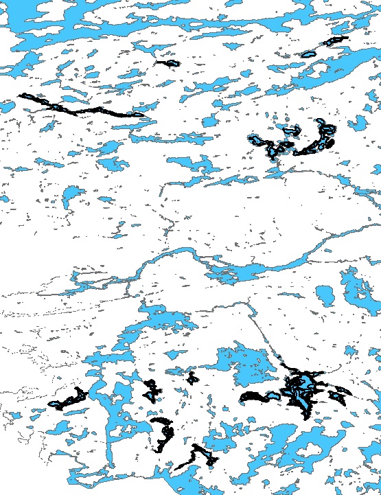
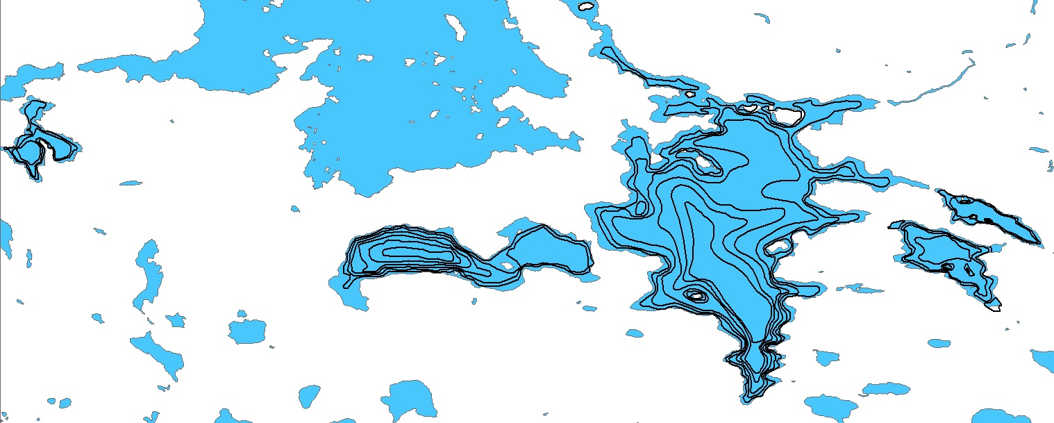
The picture below is to give an idea of the distance between lakes and the picture at the bottom is a more zoomed in view of some of the lakes. I already have DEM data for the white area in the pictures. I would like to use the contours lines in the lakes to make DEM data which I could then adjust to make the shallower water light blue and the deeper lake depths a darker blue.
I tried using the TopoToRaster tool but it thinks the area between the lakes is part of the lakes and make dem data for the entire area. Can the TopoToRaster tool do only the lakes with the contour lines? How? Or, is there there a better tool for this?
Solved! Go to Solution.
- Mark as New
- Bookmark
- Subscribe
- Mute
- Subscribe to RSS Feed
- Permalink
- Report Inappropriate Content
You can use the Set Null (spatial analyst) tool to define areas of "no data". You should do the no data/NULL ing only after you've created both the bathymetry and /terrain DEM rasters. your outputs should all be rasters not shapefiles. You could also merge the bathymetry and terrain DEM rasters but it will be a pain getting the symbology/color ramp to work right. Keeping them separate and just using no color for NULL/no data pixels will be easier by displaying them at the same time but with their own separate color ramps. I would also probably include the lake shoreline as an outline with no FILL color (as a shapefile if you want) so you can give it a distinctive color/width that will allow you to highlight it against the terrain /bathymetry.
- Mark as New
- Bookmark
- Subscribe
- Mute
- Subscribe to RSS Feed
- Permalink
- Report Inappropriate Content
Thanks for the help. Sorry, for all the questions but this is all new to me. I already have a terrain DEM raster. After I create the bathymetry DEM raster, then I use the Set Null feature of the Spatial Analyst tool to define areas of "no data", do I define the areas of no data on the newly created bathymetry DEM raster and also on the terrain DEM Raster that I already have? For the bathymetry, everything not in those lakes is no data and for the terrain, the specific lakes on the bathymetry raster get marked as non data?
- Mark as New
- Bookmark
- Subscribe
- Mute
- Subscribe to RSS Feed
- Permalink
- Report Inappropriate Content
Yes.
- Mark as New
- Bookmark
- Subscribe
- Mute
- Subscribe to RSS Feed
- Permalink
- Report Inappropriate Content
Sorry for the delay, I won't be able to work on this until the weekend.
- Mark as New
- Bookmark
- Subscribe
- Mute
- Subscribe to RSS Feed
- Permalink
- Report Inappropriate Content
You can create TIN from contours
Then convert TIN to DEM
This clip will help you Coutours to DEM in ArcGIS - YouTube
- Mark as New
- Bookmark
- Subscribe
- Mute
- Subscribe to RSS Feed
- Permalink
- Report Inappropriate Content
Thank You! I just watched the video and it looks like it will work great. I will try it later today and report back.
I learned from the video that you can drag and drop from the Table of Contents (on the left side of ArcMap) to the pop-up window of whatever tool you are using.
- Mark as New
- Bookmark
- Subscribe
- Mute
- Subscribe to RSS Feed
- Permalink
- Report Inappropriate Content
Rick, just looking at your screenshot, I wanted to warn you to make sure your output coordinate system is set to a projected coordinate system -- interpolation using unprojected (geographic) coordinates is usually invalid because distances on the ground in x and y are different, especially so at high latitudes.
- Mark as New
- Bookmark
- Subscribe
- Mute
- Subscribe to RSS Feed
- Permalink
- Report Inappropriate Content
I'm new at this and learning as I go. Is there anything I should do differently? Or, should I just try your solution and see how it works? If it makes a difference the area is Quetico Provincial Park on Ontario, Canada, I'm not sure if that qualifies as high latitude.
- Mark as New
- Bookmark
- Subscribe
- Mute
- Subscribe to RSS Feed
- Permalink
- Report Inappropriate Content
Ontario is far enough north, though you should probably work in projected space anywhere -- see how your hydrography looks squished out in your screenshot?
Just before you run these tools, go to Geoprocessing > Environments and set the output coordinate system to a reasonable projection for that part of the world. UTM (use the proper zone, and probably NAD83 datum) is always a good default choice unless your study area is really wide east to west (> 500 km) You also want to change the data frame coordinate system to a projected coordinate system.
What are projected coordinate systems?—Help | ArcGIS Desktop
- Mark as New
- Bookmark
- Subscribe
- Mute
- Subscribe to RSS Feed
- Permalink
- Report Inappropriate Content
I watched the You Tube video create raster/ DEM from coutours line in arcgis - YouTube and now that I am at my computer with ArcMap running, now I am getting an error message stating: "This video is no longer available because the YouTube account associated with this video has been terminated"
I can't remember the details of the video. It seems like a tool was used to create a "TIN" from the vector shapefile of the lake depth contour lines. Then, the TIN was converted to ?? something? Does anyone else get the YouTube error message? Do anyone see the video and remember which tools were used?