- Home
- :
- All Communities
- :
- Products
- :
- Mapping and Charting Solutions
- :
- Mapping and Charting Questions
- :
- Re: ArcGIS 10.5 Euclidean Distance-Ouputraster wit...
- Subscribe to RSS Feed
- Mark Topic as New
- Mark Topic as Read
- Float this Topic for Current User
- Bookmark
- Subscribe
- Mute
- Printer Friendly Page
ArcGIS 10.5 Euclidean Distance-Ouputraster with wrong values
- Mark as New
- Bookmark
- Subscribe
- Mute
- Subscribe to RSS Feed
- Permalink
- Report Inappropriate Content
The output of my Euclidean distance from Roads seems to show the calculations only until the last feature ot the bottom. The process extend goes on though, but shows wrong values. It should get brighter instead of being dark (like on the other sides)
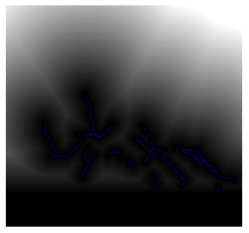
With dark beeing close to roads and bright further away.
What did I do wrong/ Do i have to do to get raster values to the full extend of the processing extend?
Note:I got this feature (mainroads) by deleting some other features (sideroads) from the original feature (main and side roads). The above mentioned problem does not occur with the original feature.
- Mark as New
- Bookmark
- Subscribe
- Mute
- Subscribe to RSS Feed
- Permalink
- Report Inappropriate Content
What is in the legend?
What are the value ranges?
When you say they are wrong, what is this based on?
Have you inspected the pixel values?
- Mark as New
- Bookmark
- Subscribe
- Mute
- Subscribe to RSS Feed
- Permalink
- Report Inappropriate Content
Thanks for the response!
The distance is measured in meters and ranges from 0 to 32805,6

They are wrong because the pixel values in the lowest extend part tell me that they are on a road (all Pixel values are 0 ), although there is no road feature (blue) near them.
So it looks as if ArcGIS thinks, that to the lower extent limit(everything lower then the lowest actual road feature) is a road too? Does that make sense?
- Mark as New
- Bookmark
- Subscribe
- Mute
- Subscribe to RSS Feed
- Permalink
- Report Inappropriate Content
I am just wondering what your nodata value is and if it happens to be the same as the road
- Mark as New
- Bookmark
- Subscribe
- Mute
- Subscribe to RSS Feed
- Permalink
- Report Inappropriate Content
Would really like to see the input data (where the roads converted to raster first), what extents have been defined form the input data and for the environment settings? Can you share the roads, to see if I can reproduce?
- Mark as New
- Bookmark
- Subscribe
- Mute
- Subscribe to RSS Feed
- Permalink
- Report Inappropriate Content
Hey the only way I was able to share them was to 7zip the GDP and upload it to my dropbox:
It contains...
-original file geodatabase feature class: roads_total
-the derived raster: roads_total_eucdist_r10
-the derived roads of category 1: roads_cat1
-the derived raster: roads_cat1_eucdist_r10
-the working extend raster: working_extent_r10
I hope it works.
Thanks for the interest!
- Mark as New
- Bookmark
- Subscribe
- Mute
- Subscribe to RSS Feed
- Permalink
- Report Inappropriate Content
This is what I got
I use the Working_extend_r10 to determine the cell size, the extent and the snap raster.
I did it with both the featureclass and the featureclass converted to a raster... using the above set parameters.
I got this in both cases.
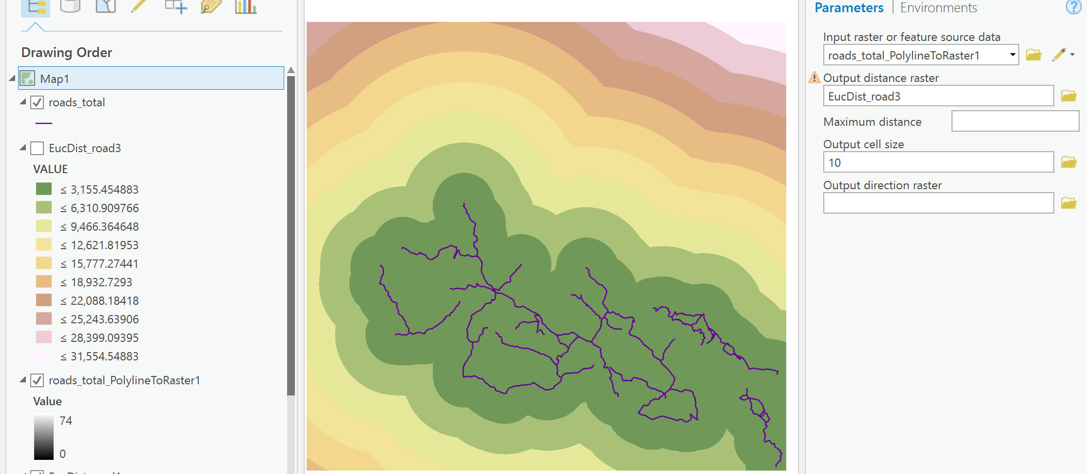
the other extent raster was crooked
the other featureclass I dumped since it appeared it was part of the total
anything out of sorts? from what you did?
- Mark as New
- Bookmark
- Subscribe
- Mute
- Subscribe to RSS Feed
- Permalink
- Report Inappropriate Content
Thank you very much. If i convert to raster before doing the eucliean distance it works. Thats good enough for me.
- Mark as New
- Bookmark
- Subscribe
- Mute
- Subscribe to RSS Feed
- Permalink
- Report Inappropriate Content
It really is not necessary to convert the roads to raster before the euclidean distance calculation. It all depend on the used extent.
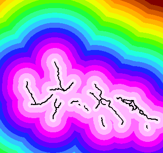
This is you result that you included:

This is the one I calculated using the selection of roads in roads_cat1:
In case you don't have a first raster to use as extent and snap raster, you can set the extent using values in the environment settings. I noticed that the extent you used look like this:
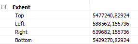
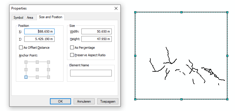
When possible define the values of the extent as rounded values and multiples of the cell size. You can use a rectangle and draw that around the data to define the coordinate:
- Mark as New
- Bookmark
- Subscribe
- Mute
- Subscribe to RSS Feed
- Permalink
- Report Inappropriate Content
I used Working_extend_r10 to define the extent Xander, as well using it as the snap raster and to determine the cell size. Converting the roads (the full set, not the partial set one) to raster used those parameters as well to ensure that everything has the same environments.. Ditto for the Euclidean distance. I suspect it was a mishmash of mixed inputs, so I didn't even try to replicate what was observed.