- Home
- :
- All Communities
- :
- Products
- :
- Mapping and Charting Solutions
- :
- Mapping and Charting Questions
- :
- ArcGIS World Geocoding Service - How do we derive ...
- Subscribe to RSS Feed
- Mark Topic as New
- Mark Topic as Read
- Float this Topic for Current User
- Bookmark
- Subscribe
- Mute
- Printer Friendly Page
ArcGIS World Geocoding Service - How do we derive output geometry from display fields?
- Mark as New
- Bookmark
- Subscribe
- Mute
- Subscribe to RSS Feed
- Permalink
According to the Geocoding options properties section of Help (http://desktop.arcgis.com/en/arcmap/latest/manage-data/geocoding/geocoding-options-properties.htm), we should be able to derive output geometry from display fields (DisplayX, DisplayY). The ArcGIS World geocoding service generates (DisplayX, DisplayY) when I geocode, but I don't see a way to use these fields instead of (X, Y). More than half of my points are PointAddress quality, and I would like to use these values. All of my points, including PointAddress points, are displayed along streets instead rooftops.
We are using ArcMap 10.6.
- Mark as New
- Bookmark
- Subscribe
- Mute
- Subscribe to RSS Feed
- Permalink
Mark,
The documentation you are referring to above is for locally built locators and our Street Map Premium locators.
If you would like to get the geometry based on the "Address Location" (Geometry that represents an address location such as rooftop location, parcel centroid, or front door) for the ArcGIS World Geocoding Service and you are using version 10.6 or Pro 2.1 or newer, there is an option to set the "Preferred Location Type". The is exposed in the Geocode Addresses Geoprocessing tool in ArcMap and Pro as well as the Geocode Table tool in Pro. Here is the corresponding documentation.
- Mark as New
- Bookmark
- Subscribe
- Mute
- Subscribe to RSS Feed
- Permalink
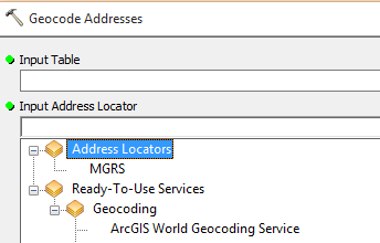
The "Preferred Location Type" option sounds promising, however the ArcGIS World geocoding service is not an option in the "Input Address Locator" dropdown of the "Geocode Addresses" Tool, only "MGRS". Is there a way to add World geocoding service to this dropdown?
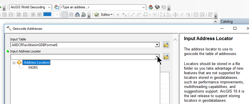
The ArcGIS World Geocoding Service IS an option in the Geocoding Toolbar, so I am able to geocode, but the "Preferred Location Type" option is not available.

As a workaround, I can geocode my addresses using the ArcGIS World Geocoding Service and then export the resulting feature class as a text file. In ArcCatalog, I can RMB on the text file, select Create Feature Class > From XY table and select DisplayX and DisplayY as my X and Y fields respectively.
Thanks for your help.
- Mark as New
- Bookmark
- Subscribe
- Mute
- Subscribe to RSS Feed
- Permalink
Mark,
You would need to log in first for the ArcGIS World Geocoding Service to show up when using the Geocode Addresses tool. This tool consumes credits when geocoding against the online service, because the results are stored, so it requires credentials in order for it to show up.
Close the tool and go to File > Sign In...
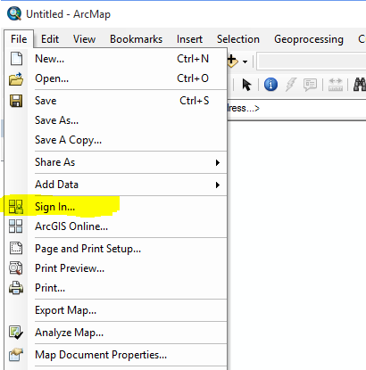
It will take a few seconds to log in and then you can reopen the Geocode Addresses tool and the ArcGIS World Geocoding Service will be in the dropdown now.