- Home
- :
- All Communities
- :
- Products
- :
- ArcGIS GeoEvent Server
- :
- ArcGIS GeoEvent Server Questions
- :
- Re: Verizon Network Fleet - GeoEvent Definition Ma...
- Subscribe to RSS Feed
- Mark Topic as New
- Mark Topic as Read
- Float this Topic for Current User
- Bookmark
- Subscribe
- Mute
- Printer Friendly Page
Verizon Network Fleet - GeoEvent Definition Manipulation
- Mark as New
- Bookmark
- Subscribe
- Mute
- Subscribe to RSS Feed
- Permalink
- Report Inappropriate Content
Hello,
First off, I am new to the GeoEvent processor, so I apologize if this is rudimentary. I am trying to utilize the Networkfleet adapter and have successfully configured the feed from Verizon to create features and update features based on the instructions in the guide:
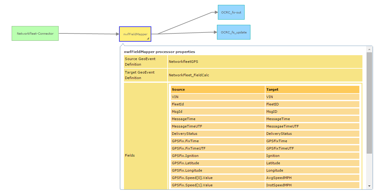
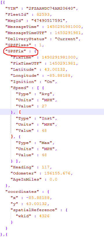
My question, is that this field mapper to feature service connection grabs from the NetworkfleetGPS GeoEvent Definition. How do I create features from the other definitions? Specifically NetworkfleetDiagnostic and NetworkFleetSensor. I have created a flat file like so:
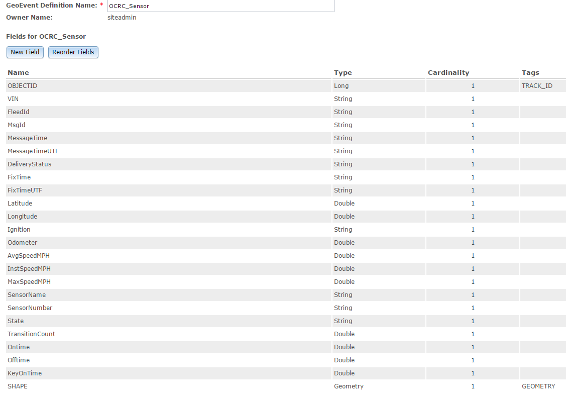
Then I map the fields from NetworkFleetSensor to OCRC_Sensor and add a Feature (i'll get to the JSON in a minute):
Which gives me the following output.
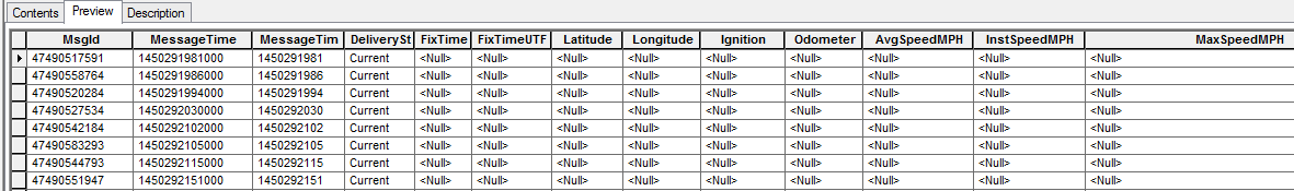
I think the reason for the null values starting with FixTime is that I am not accessing the Sensor data and that is what I am wondering is how do I access/view that sensor data? When I create the JSON file, all I am seeing is the NetworkfleetGPS file in JSON. So with the prefix of SensorFix.SensorName = SensorName, in the field mapper, it won't populate with anything, because nothing is there...
I hope this makes sense. I am just trying to figure out how to access and view the data from the other geoevent Definitions created by the Networkfleet-adapter-10.3.0.jar.
I am using ArcGIS 10.3.1
Solved! Go to Solution.
Accepted Solutions
- Mark as New
- Bookmark
- Subscribe
- Mute
- Subscribe to RSS Feed
- Permalink
- Report Inappropriate Content
Hi Marshall,
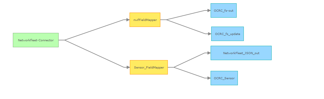
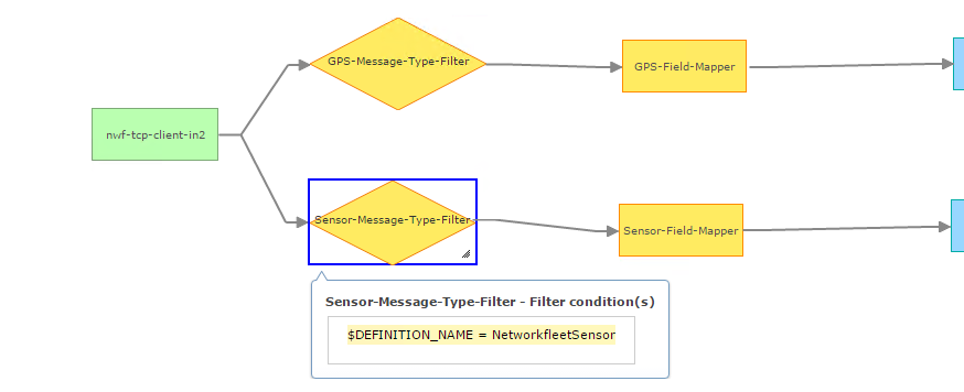
Verizon Networkfleet data will come in with multiple message types in one input stream. Before passing the data to a Field Mapper, it is important to put a Filter by GeoEvent Definition Name before it to prevent message with wrong types getting to the Field Mapper. The structure of the NetworkfleetGPS and NetworkfleetSensor are very similar (they have many fields with the same name and type). Your current processing logic allows any message type to get to both Field Mappers causing null values in the results due to the absence of fields when the unintended message type get to the Field Mappers. Wrong value with the same field name also get mapped to the destination message causing the results to be confusing and unreliable.
The screenshot below is an example of how the filters by GeoEvent Definition Name are applied before the Field Mappers.
Hope this helps,
Morakot
- Mark as New
- Bookmark
- Subscribe
- Mute
- Subscribe to RSS Feed
- Permalink
- Report Inappropriate Content
Hi Marshall,
Verizon Networkfleet data will come in with multiple message types in one input stream. Before passing the data to a Field Mapper, it is important to put a Filter by GeoEvent Definition Name before it to prevent message with wrong types getting to the Field Mapper. The structure of the NetworkfleetGPS and NetworkfleetSensor are very similar (they have many fields with the same name and type). Your current processing logic allows any message type to get to both Field Mappers causing null values in the results due to the absence of fields when the unintended message type get to the Field Mappers. Wrong value with the same field name also get mapped to the destination message causing the results to be confusing and unreliable.
The screenshot below is an example of how the filters by GeoEvent Definition Name are applied before the Field Mappers.
Hope this helps,
Morakot
- Mark as New
- Bookmark
- Subscribe
- Mute
- Subscribe to RSS Feed
- Permalink
- Report Inappropriate Content
That is exactly what I am looking for. Through this process, I realized that when I requested the feed, I didn't ask for anything else beside GPS.
Thanks so much for the help.
- Mark as New
- Bookmark
- Subscribe
- Mute
- Subscribe to RSS Feed
- Permalink
- Report Inappropriate Content
It looks like I am having the same issues as the original poster. I have set up the GPS feed with the filter and field mapper processor. I have two outputs running, a stream service and an output to feature in a sql database. I can see all of the correct attribute information in the stream service, but the GPSFixTime, GPSFixTimeUTF, Lat/Long, Speed, Ignition, Heading, and Odometer attributes are not carrying over to the features/database. I am getting all NULL values.
Any suggestions on troubleshooting?
- Mark as New
- Bookmark
- Subscribe
- Mute
- Subscribe to RSS Feed
- Permalink
- Report Inappropriate Content
Hi Cassidy,
Make sure the field names and types of the outgoing GeoEvent definition match correctly with the schema of the target Feature Service/Feature Class. They are case sensitive (database dependent). One way to make sure of this is to import the GeoEvent definition from the feature layer of the target feature service. If this is not the case then I would suggest to get in touch with Esri Technical Support to get someone to help diagnosing the problem.
Morakot