- Home
- :
- All Communities
- :
- Products
- :
- ArcGIS GeoEvent Server
- :
- ArcGIS GeoEvent Server Questions
- :
- Re: Could not visualize GeoEvent tutorial modul 2 ...
- Subscribe to RSS Feed
- Mark Topic as New
- Mark Topic as Read
- Float this Topic for Current User
- Bookmark
- Subscribe
- Mute
- Printer Friendly Page
Could not visualize GeoEvent tutorial modul 2 real-time data in ArcGis Online and Portal for ArcGIS...
- Mark as New
- Bookmark
- Subscribe
- Mute
- Subscribe to RSS Feed
- Permalink
- Report Inappropriate Content
Hi
I am using tutorial data for learning GeoEvent real-time visualisation.In module 2 I did it all, but I could not visualize tutorial sample data in the portal and Arcgis online.
It can not activated the interval panel in the ArcGis Online Content panel.
I attached screenshot.
How can I pass this step, could you help me ?
- Mark as New
- Bookmark
- Subscribe
- Mute
- Subscribe to RSS Feed
- Permalink
- Report Inappropriate Content
Hi Emil,
It sounds like to me that there are two separate issues here. The first problem is that the refresh rate settings aren't displaying on your service, and the second problem is that you cannot visualize the data.
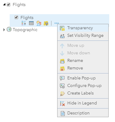
For the first problem involving the refresh rate settings, I would double check the steps you followed in the module (specifically page 33). The tutorial discusses copying the FeatureServer REST URL and not the MapServer REST URL. From what I have observed, the refresh rate property isn't applicable to the map service (since it is returning a Map Export, as opposed to a query). I'd be willing to guess that you had accidentally copied the MapServer REST URL.
To demonstrate this, here is what I saw when I added the map service to my web map (notice the nested layer and how it is similar to your screenshot):
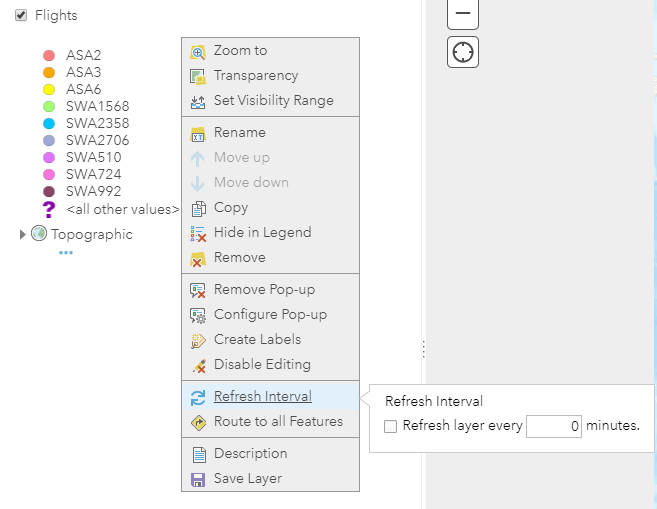
Likewise, here is what is available when the feature service is added to the web map. This matches the tutorial.
To really address the second problem involving the failed visualization, we'll need more information about your configuration to truly say what the source of the problem is. Without knowing more about what you're specifically seeing, there's a few general suggestions I can offer. For example, does your outbound GeoEvent Definition schema match the schema of the published feature service? Are you witnessing event records come inbound from the GeoEvent Simulator over tcp? Is your GeoEvent Server processing the event records inbound and outbound? Are you able to see the same data that is going to your Flights feature service but within the GeoEvent Logger? If data is in fact being sent to your Flights feature service, have you tried querying the features at the REST endpoint to see if there's valid geometry?
These are just a few things I might suggest checking in order to move forward again. If you have any further information about what you're seeing happen (& vice-versa), then please feel free to share so that the community here may better aid you. Likewise, Esri Support Services is always available to assist with the tutorial materials should you like to have a conversation.