- Home
- :
- All Communities
- :
- Developers
- :
- ArcGIS Windows Mobile (Retired)
- :
- ArcGIS Windows Mobile Questions
- :
- Re: Trimble Positions Thread - Post Here
- Subscribe to RSS Feed
- Mark Topic as New
- Mark Topic as Read
- Float this Topic for Current User
- Bookmark
- Subscribe
- Mute
- Printer Friendly Page
Trimble Positions Thread - Post Here
- Mark as New
- Bookmark
- Subscribe
- Mute
- Subscribe to RSS Feed
- Permalink
- Report Inappropriate Content
- Mark as New
- Bookmark
- Subscribe
- Mute
- Subscribe to RSS Feed
- Permalink
- Report Inappropriate Content
I've got a new problem and I'm trying to figure out whether it's an IT issue or something I did.
I use ArcGIS 10.2 + Trimble Positions Desktop + ArcPad extension.
Up until recently everything was running smoothly, I was able to check out data, collect data, check it in, post process it, and update my collected features to a geodatabase.
Recently, the last step in the workflow - the "Update Features" step - fails. Actually, it doesn't fail, it just doesn't work. I press the button and nothing happens. This is only occurring for one geodatabase that I use. Others will update, no problem.
Has anyone experienced this before?
- Mark as New
- Bookmark
- Subscribe
- Mute
- Subscribe to RSS Feed
- Permalink
- Report Inappropriate Content
The lack of a failure notification is really odd.
I recently experienced failure to update notifications when trying to update corrected polylines in a geometric network.
Is anyone aware of a workaround for this? I am planning on writing a script to create the network with the rules anyway, this problem makes the script more urgent.
- Mark as New
- Bookmark
- Subscribe
- Mute
- Subscribe to RSS Feed
- Permalink
- Report Inappropriate Content
I am having trouble when using and SDE geo database. After export, when i open the map on a GEO XT 6000 windows mobile 6.1 in ArcPAD I receive the attached error message. If I use a file geodatabase locally then I don't receive the error. I need to use SDE geodatabase in SQL.
Any ideas?
Thanks.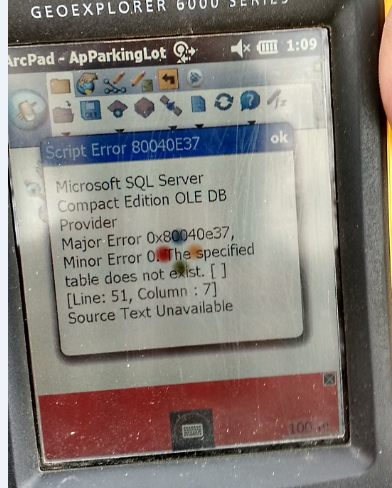
- Mark as New
- Bookmark
- Subscribe
- Mute
- Subscribe to RSS Feed
- Permalink
- Report Inappropriate Content
Hello James.
Welcome to the GPS world. You are right to say that it doesn't work. The
reason is that the technology only allows file geodatabases at this point
in the game. However, I anticipate that it will change and add other data
types.
In kind spirit,
DIGGY
Darryl Sanchez
Realty Specialist
Real Estate Services
Bureau of Indian Affairs
Northern Cheyenne Agency
Lame Deer, Montana
Phone#: (406) 477-8286
Fax#: (406) 477-8281
*People are definitely the U.S. Government’s 20th greatest asset. It does
not make any difference whether their service is civilian or military. The
U.S. government is only as good as the people it keeps.*
-Darryl Sanchez 2013
- Mark as New
- Bookmark
- Subscribe
- Mute
- Subscribe to RSS Feed
- Permalink
- Report Inappropriate Content
HI Darryl,
I am pretty much 99.2% certain that I had this working up until about 4 weeks ago.
I am running Arc Desktop 10.2.1, ArcPAD 10.2 and Trimble Positions Arc-pad add-in for Windows Mobile 10.2.
I am exporting layers from Arc Desktop via the Trimble Positions for Desktop Add-in.
I am not sure what happened but one day i just started receiving this error on every thing that I exported to ArcPAD that was tied to a SQL database connection (SDE?)
Anyway if you are certain that Trimble Positions Desktop Add-IN won't export to ArcPAD correctly when using an sql database, please let me know again.
But like i said, I am pretty sure I had this going once and I don't know what changed.
Thanks!
James Hickey
- Mark as New
- Bookmark
- Subscribe
- Mute
- Subscribe to RSS Feed
- Permalink
- Report Inappropriate Content
Hello again,
That is just crazy. I was always told that only file geodatabases were the
only format that the GPS software worked with. I will look into it if I
find out any different I will let you know.
In kind spirit,
Darryl Sanchez
Realty Specialist
Real Estate Services
Bureau of Indian Affairs
Northern Cheyenne Agency
Lame Deer, Montana
Phone#: (406) 477-8286
Fax#: (406) 477-8281
*People are definitely the U.S. Government’s 20th greatest asset. It does
not make any difference whether their service is civilian or military. The
U.S. government is only as good as the people it keeps.*
-Darryl Sanchez 2013
- Mark as New
- Bookmark
- Subscribe
- Mute
- Subscribe to RSS Feed
- Permalink
- Report Inappropriate Content
Hi Darryl.
This works now. See posts below for explanation. There is also a link provided by Jorge Orellana that pointed me in the right direction.
Good luck!
James
- Mark as New
- Bookmark
- Subscribe
- Mute
- Subscribe to RSS Feed
- Permalink
- Report Inappropriate Content
- Mark as New
- Bookmark
- Subscribe
- Mute
- Subscribe to RSS Feed
- Permalink
- Report Inappropriate Content
Gold!!! thank you for finding and posting that!
This was the remedy! And here was my post back to that forum.
Fantastic!!!
I have been working on this since Monday!
Our set up is: A GeoXT 6000 running Windows Mobile 6.1, ArcPAD 10.2 for Mobile, Trimble Positions Add-in for ArcPAD 10.2.
On PC: Windows 7 64bit SP1, ArcGIS Desktop 10.2, ArcPAD 10.2 for Desktop, Trimble Positions Add-in for Desktop 10.2.
I was receiving the same SQL error:

In order to remedy this solution I had to remove the QuickField Applets from the GeoXT 6000's program files.
Located at DeviceStorage/Program Files/Arc Pad/Applets
I created a sub directory called quickFieldBackup and moved all of the Files that started with QuickField into this.
Everything works great after that!
Thank you a ton!
James Hickey
- Mark as New
- Bookmark
- Subscribe
- Mute
- Subscribe to RSS Feed
- Permalink
- Report Inappropriate Content
I'm having an issue with the Compatibility Testing on the Enable GNSS screen. When I run the test it tells me to "Please define a datum transformation for feature class [XXX]." I've already set a transformation in the ArcMap data frame as well as the Positions Datum Transformations dialogue (says it's for ArcPad and I'm using Mobile but figured it couldn't hurt).
I'm not aware of anyway to set a transformation to one specific feature class in ArcMap without actually modifiying the source data which isn't and option... am I missing something?
Thanks.
Bart