- Home
- :
- All Communities
- :
- Products
- :
- ArcGIS for Power BI
- :
- ArcGIS for Power BI Questions
- :
- Using Custom Polygon Locations from Layer in Power...
- Subscribe to RSS Feed
- Mark Topic as New
- Mark Topic as Read
- Float this Topic for Current User
- Bookmark
- Subscribe
- Mute
- Printer Friendly Page
Using Custom Polygon Locations from Layer in Power BI
- Mark as New
- Bookmark
- Subscribe
- Mute
- Subscribe to RSS Feed
- Permalink
- Report Inappropriate Content
I have election results that are given at a block code level (block code is a collection of a couple of hundred houses more or less). Each block is assigned an 8-9 digit ID (like 153040101)
This is a short sample of the election results table.
I want to represent the election results in on a map based on any specific scenario I want. Like this:

This map is from a JSON file that was prepared for ArcGIS map.
When this map file is upload on ArcGIS account and used in Power BI, I get the outlined blockcodes correctly.
But the problem is, I’m unable to display any information on these block codes (or even interact with them through any filters on Power BI – like I was able to do when I used the same map as shape map.
I have used ‘join layer’ function to join block codes from the map layer with block codes from my own data in the table. I have enabled the ‘Interact with Power BI visuals’ but it does not work.
My desired result is to get the visuals like I got when I used shape map visual but on ArcGIS.
Any help on this would be much appreciated.
Solved! Go to Solution.
Accepted Solutions
- Mark as New
- Bookmark
- Subscribe
- Mute
- Subscribe to RSS Feed
- Permalink
- Report Inappropriate Content
Currently, PBI doesn't support polygon joins. What we end up doing is publishing the layer with the symbology to portal then adding it to PBI as a reference layer. The problem with this solution is that it disconnects it from your PBI data and other visualizations.
- Mark as New
- Bookmark
- Subscribe
- Mute
- Subscribe to RSS Feed
- Permalink
- Report Inappropriate Content
Please find the links to my proposed solutions as posted previously under "Shape in Geojson" post (see links below)
- The methods does not use the existing/standard boundaries
- The methods does not use "join layer"
- It uses the true geometry of your custom geometries linked to Power BI visualizers
- You can then change symbology/styling based on a field for color or size
1. Using Power Automate procedure - Basic and Advanced Method (from @SeanKMcGinnis )
2. Using REST API (without Power Automate) procedure
Hope this helps.
- Mark as New
- Bookmark
- Subscribe
- Mute
- Subscribe to RSS Feed
- Permalink
- Report Inappropriate Content
Thanks,
Have you tested this with publishing to a Power BI Gateway? I know that the address locations cannot be published, only Lat/Longs. This is a main requirement for our users.
- Mark as New
- Bookmark
- Subscribe
- Mute
- Subscribe to RSS Feed
- Permalink
- Report Inappropriate Content
Hi @KevinDunlop ,
No I have not tried Power BI Gateway, but i have tested through the Publish to a "Website or Portal" Embedded report.
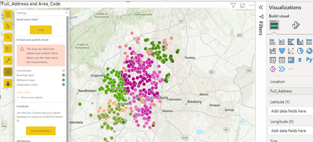
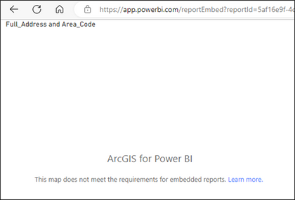
Yes, you are correct that the Addresses fail when published. I tested in ArcGIS for Power BI "Embed and publish check" Tool under Settings.
After Publishing ->
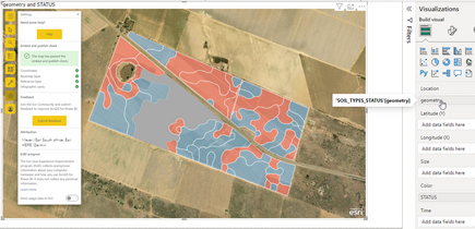
What does work is the Custom Geometries. See below:
Embed check - coordinates - OK
Publish embedded report - OK
The only thing is that even if your data is share Publicly you still need to be logged into an ArcGIS, even if it's only a Viewer type, for this to work.
Maybe a solution for the Addresses is to run a ArcGIS for Power Automate process to Geocode and it will write the XY coord values to fields and then you can use that in the Lat Long coordinate fields.
See link: https://learn.microsoft.com/en-us/connectors/arcgis/#geocode-addresses
There is a way to batch the process if the number of address go over the limit of 150 - see link below:
https://community.esri.com/t5/arcgis-for-power-automate-blog/using-arcgis-connectors-for-power-autom... (Thanks @SeanKMcGinnis )
Hope this helps.
- Mark as New
- Bookmark
- Subscribe
- Mute
- Subscribe to RSS Feed
- Permalink
- Report Inappropriate Content
Hi @RudolfdeMunnik,
Is it possible to do all these steps not publicly. Where do I find the rest API? Does it need a token?


