- Home
- :
- All Communities
- :
- Products
- :
- ArcGIS for Microsoft
- :
- ArcGIS for Microsoft Fabric
- :
- ArcGIS for Power BI
- :
- ArcGIS for Power BI Questions
- :
- Switch to using 2010 Census Tracts?
- Subscribe to RSS Feed
- Mark Topic as New
- Mark Topic as Read
- Float this Topic for Current User
- Bookmark
- Subscribe
- Mute
- Printer Friendly Page
Switch to using 2010 Census Tracts?
- Mark as New
- Bookmark
- Subscribe
- Mute
- Subscribe to RSS Feed
- Permalink
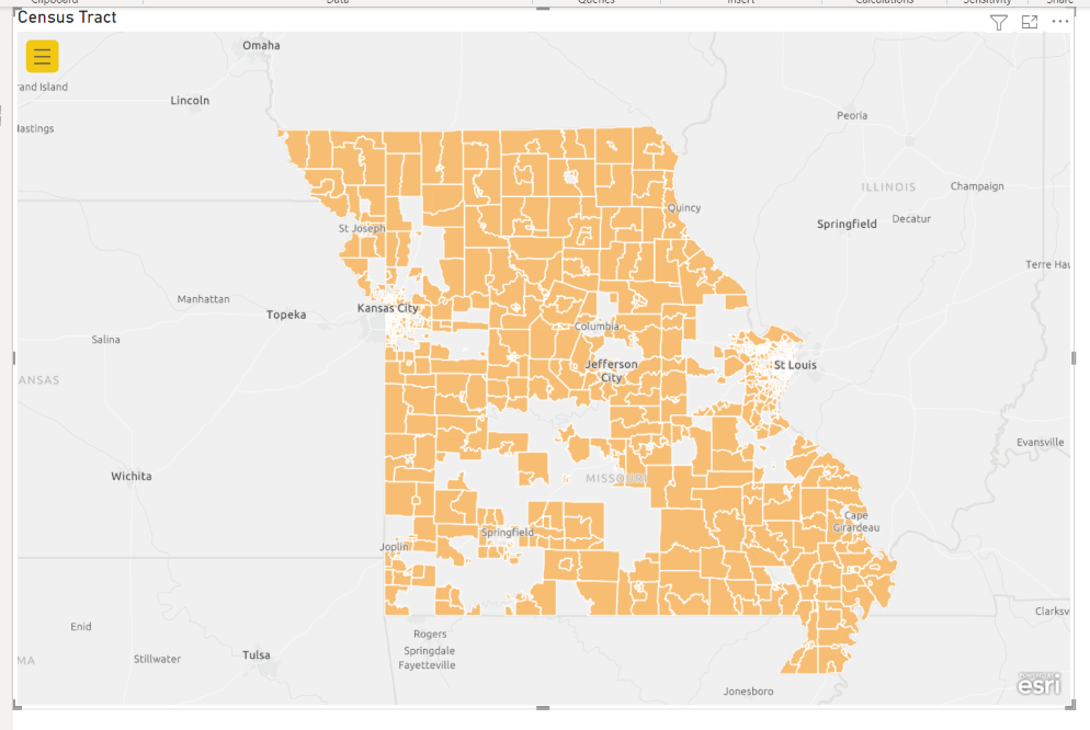
It appears that with the update to version 2022.3.109 the Census tract geography with switched from 2010 to 2020. I have a a number of visualizations in use at the 2010 Census Tract level that are now failing to render correctly. Is there a way to switch to using the 2010 Census tract geography or to revert back to the previous version of ArcGis Maps for Power BI? The attached image shows the an example of much of the territory of a state failing to render due to changes in Census tracts from 2010 to 2020.
- Mark as New
- Bookmark
- Subscribe
- Mute
- Subscribe to RSS Feed
- Permalink
Hi @pacyleterson ! My name is Sarah and I am a product engineer on the ArcGIS for Power BI team. I am interested in looking more into this so I can help out if possible!
The first thing I notice in your screenshot is that the layer is not rendering all polygons properly. Would it be possible to share the Missouri 2010 Tract data you are using (or a modified copy) so I an see if I can reproduce this issue on my end?
- Mark as New
- Bookmark
- Subscribe
- Mute
- Subscribe to RSS Feed
- Permalink
Thanks Sarah. Attached is a sample dataset using the same source as the report displayed that contains all US census tracts in the US using the 2010 FIPS code. (A small number of tracts with a population of zero, such as airports, are not included.)
Please let me know if there is anything else I can do to help investigate.
- Mark as New
- Bookmark
- Subscribe
- Mute
- Subscribe to RSS Feed
- Permalink
Thanks @pacyleterson , we are currently working with the rest of team on this. I will get back to you as soon as I have more information!
- Mark as New
- Bookmark
- Subscribe
- Mute
- Subscribe to RSS Feed
- Permalink
Hi @SarahRosenthal1 . I was hoping to check in to see if there is any update on making the 2010 Census tract geography available for use in ArcMaps for power BI. Thanks.
- Mark as New
- Bookmark
- Subscribe
- Mute
- Subscribe to RSS Feed
- Permalink
Hey @pacyleterson, thank you so much for your patience on our response! After running this by several people there are a few ways we could go about helping you. Would you be willing to privately message my colleague @Anonymous User to set up a time to chat? Thanks and looking forward to connecting soon!
- Mark as New
- Bookmark
- Subscribe
- Mute
- Subscribe to RSS Feed
- Permalink
Hi Sarah- I know this is a previous thread from several months ago, but my team is also trying to switch our map back to 2010 census tracts until we finish our internal transition to using 2020 census tracts for our data. Is there a way to do that in the arcgis visual for powerbi? Thanks!
- Mark as New
- Bookmark
- Subscribe
- Mute
- Subscribe to RSS Feed
- Permalink
Hi @kateleandowski. Were you able to find a solution to using the 2010 Census tracts?
- Mark as New
- Bookmark
- Subscribe
- Mute
- Subscribe to RSS Feed
- Permalink
Hi, @SarahRosenthal1 - I had the same issue as @pacyleterson. Can you share the solution you came up with to be able to use 2010 Census tract boundaries?
- Mark as New
- Bookmark
- Subscribe
- Mute
- Subscribe to RSS Feed
- Permalink
I am also interested in the answer to this question. I am working on merging data sets where one is from 2010 and the other is from 2020 census shapes. Is there a way to transform one to the other to make them compatible?