- Home
- :
- All Communities
- :
- Products
- :
- ArcGIS Field Maps
- :
- ArcGIS Field Maps Questions
- :
- Re: Field Maps web app auto-enables editing on Por...
- Subscribe to RSS Feed
- Mark Topic as New
- Mark Topic as Read
- Float this Topic for Current User
- Bookmark
- Subscribe
- Mute
- Printer Friendly Page
Field Maps web app auto-enables editing on Portal layers
- Mark as New
- Bookmark
- Subscribe
- Mute
- Subscribe to RSS Feed
- Permalink
- Report Inappropriate Content
Hi all,
I have run into this issue on both Map Viewer Beta and now Field Maps Beta web app. I am on Portal 10.8.1.
I upload a feature layer of hydrants with a maintenance table to Portal with editing enabled (geometry disabled so people can't move hydrants) to allow for creation of related records in Collector/Field Maps. After uploading, in each web map I disable editing of the feature layer so that the blue + "add a feature" button is not in Collector/FM so that operators cannot add hydrants, but merely add related records. This work flow works using the normal map viewer to change these settings and configure pop-ups.
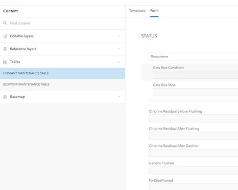
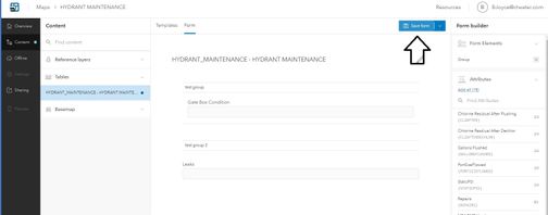
Whenever I open these in Map Viewer Beta, or in this case, Field Maps Beta web app to configure forms to make groups of inspections in the related table, after saving, it re-enables editing on my hydrant feature layer, adding the option on the mobile apps to add hydrants. This isn't an experience breaking bug for Map Viewer Beta, because I can open the map in the old map viewer, disable editing, then save there and it retains the changes. If I do this after coming from Field Maps Beta, it deletes the forms I've created.
There doesn't seem to be a way that I can utilize any sort of form grouping in Field Maps without opening the ability of people to add hydrants in the mobile app. I don't seem to have the ability to disable editing of the layers in Field Maps Beta...This is a pretty big limitation for us as I have had issues with users adding hydrants with the big shiny add button thinking they are creating an inspection. Help!
Solved! Go to Solution.
Accepted Solutions
- Mark as New
- Bookmark
- Subscribe
- Mute
- Subscribe to RSS Feed
- Permalink
- Report Inappropriate Content
Based on your screenshots, it looks like you are still using the Beta version of Field Maps for 10.8.1. There are officially released setups available to download and install from My Esri. Documentation is available here: https://doc.arcgis.com/en/field-maps/android/help/enterprise-support.htm
I think you should also get the latest Map Viewer Beta (it should also be available on My Esri). Once those are installed, you should re-test your workflow.
I think both web apps that you have installed currently are using an older version of the JS API (before 4.18) that did not persist the editing capability overrides defined in the map. The current setup for Field Maps 10.8.1 uses version 4.18 of the JS API which includes the fix for this.
- Mark as New
- Bookmark
- Subscribe
- Mute
- Subscribe to RSS Feed
- Permalink
- Report Inappropriate Content
This is probably due to the fact that enabling editing occurs at the service level. The ad-hoc editing enable/disable setting in the JS 3.x map viewer probably just hasn't been implemented in the Beta stuff yet. It feels similar to editing a Map Viewer Beta popup in the standard viewer, then losing the settings you configured in the other viewer, because it's just not looking at the same settings.
All that said, I do believe that a solution will be coming in 10.9 (hopefully!). If you look at some of the editing settings in AGOL, where you can usually get an early taste of future updates, you'll see that on the editing settings, you can configure editing capabilities differently across layers.
And then on the Data tab, you can individual fields as being editable or not.
It would be a bit of clicking (or a Python script), but you could configure the layer (or perhaps a view of the layer) to disable editing on all the fields and geometry of the hydrants layer and leave the related table open to edits.
Fingers crossed that this is coming in 10.9, rather than 10.9.1 or later.
Kendall County GIS
- Mark as New
- Bookmark
- Subscribe
- Mute
- Subscribe to RSS Feed
- Permalink
- Report Inappropriate Content
@BrendonJoyce1I can look into this. There was a related bug in the JavaScript API that both Field Maps and Map Viewer Beta use to save webmaps: BUG-000136459. I'm guessing it may be related or similar to that. For ArcGIS Online that has been patched but it was not fixed in time for 10.8.1.
Are you using hosted feature layers? If so, you should be able to create a view that disables the geometry editing of the view layer and then you don't need to worry about configuring it in each map.
- Mark as New
- Bookmark
- Subscribe
- Mute
- Subscribe to RSS Feed
- Permalink
- Report Inappropriate Content
Hi Aaron,
I do not think I am using hosted feature layers. That would be making a copy of my data, then publishing it right? I am publishing versioned/registered feature layers to retain the ability of weekly updates via reconcile.
- Mark as New
- Bookmark
- Subscribe
- Mute
- Subscribe to RSS Feed
- Permalink
- Report Inappropriate Content
Correct, you are not using hosted layers.
Can you check a couple of things:
1. Do you have the latest Map Viewer Beta installed (there have been a few Beta releases for 10.8.1)?
2. Do you have the latest Field Maps web installed?
I'm testing with hosted feature layers. When you disable editing in the Classic Map Viewer it should mark the layer has query only just for that map. When I open that same map in the Map Viewer Beta and save it, I see it persist that setting. I'm unable to reproduce the issue so. I can try with SDE layers though I don't think it will make a difference.
Can you clarify the exact workflow? Is it this:
1. Publish new feature service with geometry editing disabled
2. Add new layer and table to a new webmap using classic map viewer
3. Disable editing on the hydrant layer
4. Save the map
5. Open map in Field Maps web
6. Open the table layer and convert the popup to a form
7. Save the map
8. Open the map in Collector/Field Maps mobile
Then you still see the collect option to collect new hydrants?
Edit: I tested with an SDE SQL Server backed layer with geometry editing turned off and cannot reproduce the issue. I'm going to need some more details to investigate any further.
- Mark as New
- Bookmark
- Subscribe
- Mute
- Subscribe to RSS Feed
- Permalink
- Report Inappropriate Content
Hi Aaron, how would I see the versions of Map Viewer Beta and Field Maps Beta and what / where would I see the most up to date versions available?
I will try the rest but wanted to make sure of versions before I do.
Thanks
- Mark as New
- Bookmark
- Subscribe
- Mute
- Subscribe to RSS Feed
- Permalink
- Report Inappropriate Content
1. Publish new feature service with geometry editing disabled
2. Add new layer and table to a new webmap using classic map viewer
3. Disable editing on the hydrant layer
Yes, note the table stays editable for record creation. This works with classic web viewer workflow.
4. Save the map
5. Open map in Field Maps web
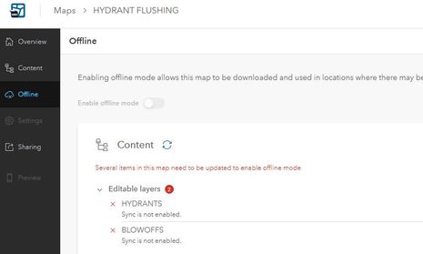
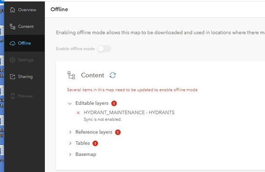
Editing is not enabled (looking in the offline tab at "editable layers") until I create the forms and save the forms
6. Open the table layer and convert the popup to a form
Correct.
7. Save the map (Save the Form)
After I save the form, in offline mode "editable layers" hydrants become editable.
8. Open the map in Collector/Field Maps mobile
They are editable if I open the map in classic web viewer, likewise, Collector/Field Maps gains add button. If I disable editing in classic web viewer and save the map, I lose the forms that were created in Field Maps.
- Mark as New
- Bookmark
- Subscribe
- Mute
- Subscribe to RSS Feed
- Permalink
- Report Inappropriate Content
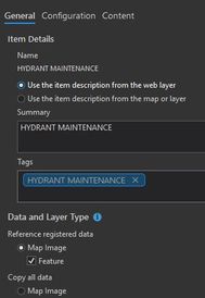
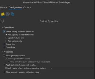
Based on your screenshots, it looks like you are still using the Beta version of Field Maps for 10.8.1. There are officially released setups available to download and install from My Esri. Documentation is available here: https://doc.arcgis.com/en/field-maps/android/help/enterprise-support.htm
I think you should also get the latest Map Viewer Beta (it should also be available on My Esri). Once those are installed, you should re-test your workflow.
I think both web apps that you have installed currently are using an older version of the JS API (before 4.18) that did not persist the editing capability overrides defined in the map. The current setup for Field Maps 10.8.1 uses version 4.18 of the JS API which includes the fix for this.
- Mark as New
- Bookmark
- Subscribe
- Mute
- Subscribe to RSS Feed
- Permalink
- Report Inappropriate Content
Thanks Aaron I will try this and post another reply with results!
- Mark as New
- Bookmark
- Subscribe
- Mute
- Subscribe to RSS Feed
- Permalink
- Report Inappropriate Content
@Anonymous User, updating Field Maps fixed this issue! I can now configure forms and groups, save, and not have it enable editing on my point layer. Thanks for this advice, this is a huge fix.
The Map Viewer Beta update also seemed to not auto-enable editing either, and now the editing toggle shows up on the properties tab of the layer as well.
