- Home
- :
- All Communities
- :
- Products
- :
- ArcGIS Explorer
- :
- ArcGIS Explorer Questions
- :
- Re: Why does my .mmpk not display when I open in E...
- Subscribe to RSS Feed
- Mark Topic as New
- Mark Topic as Read
- Float this Topic for Current User
- Bookmark
- Subscribe
- Mute
- Printer Friendly Page
Why does my .mmpk not display when I open in Explorer App?
- Mark as New
- Bookmark
- Subscribe
- Mute
- Subscribe to RSS Feed
- Permalink
- Report Inappropriate Content
I've built a .mmpk for use as an offline resource. My issue is when I open the .mmpk on an ipad the map does not initially display. When I zoom in on the map or use the find my location button that zooms me into my location the map will then display. Once zoomed in I can scroll through the map and it is quick to refresh and everything works fine, but if I zoom too far out the map will stop displaying again. I have a handful feature layers in the .mmpk; multiple county polygons, building polygons, pipe, hydrants, valves and address points. I'm wondering if its just too much to display at the full extent of the .mmpk? Ideally my map displays at the extent I built it when I open in the Explorer app. This should be possible, right? I know when I create and .mmpk with only one feature layer, the map will display the full extent of that feature layer when I open in Explorer. Why won't my .mmpk initially display when I open in explorer when the .mmpk as multiple feature layers?
- Mark as New
- Bookmark
- Subscribe
- Mute
- Subscribe to RSS Feed
- Permalink
- Report Inappropriate Content
Hey Jot Hall,
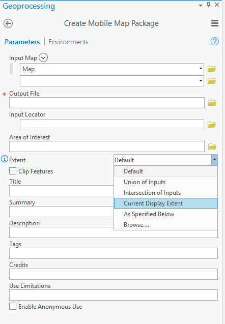
What did you choose for your extent settings when creating the mobile map package (see picture)? I tend to use Current Display Extent, and clip features that are outside this area.
A few follow-up questions though. Does your map have a basemap? Are there visibility ranges set on your operational layers? What happens if you download and open the mmpk back into Pro? Sounds like your default extent is much larger of an area than you intended and the operational layers are not displaying until you get zoomed in to the correct scale. If you can share the map with me I can take a closer look. Feel free to email me at jwhitney@esri.com
Joel
- Mark as New
- Bookmark
- Subscribe
- Mute
- Subscribe to RSS Feed
- Permalink
- Report Inappropriate Content
Joel,
I've tried using current map extent and setting the extent by a feature class layer (CWD_ServiceArea) either way I still have my display issue.
I don't have a basemap.
I do have different visibility ranges set on the different feature class layers.
The .mmpk displays properly when I load back into Arc Pro.
I will email you the .mmpk.
kindly,
Jot
- Mark as New
- Bookmark
- Subscribe
- Mute
- Subscribe to RSS Feed
- Permalink
- Report Inappropriate Content
It is the lack of basemap that is likely causing your visibility and display issues.
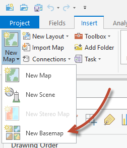
In ArcGIS Pro open your Project and insert a New Basemap
Add a feature layer that is the extent of your map to the Basemap.(It cannot be a featureclass that is in the same geodatabase as features in your map, the create mobile map package tool will not allow it).
Then in your original map of operational layers, choose the basemap you just created from the basemap gallery, to use it.
This should improve the experience in Explorer.
- Mark as New
- Bookmark
- Subscribe
- Mute
- Subscribe to RSS Feed
- Permalink
- Report Inappropriate Content
Mark,
My first attempt to add a basemap to my map has resulted in the explorer app crashing every time I try to open the .mmpk.
I used a feature layer of the service area that I would like my map to open to when initially opened in explorer.
The feature layer is from a separate geodatabase than the file geodatabase I'm using to create the mobile map package.
I'm going to try making the .mmpk with a basemap some more and see if I can get it to work. Your idea makes sense and I want it to work. I'm wondering if I did something wrong with my first attempt and or possibly my data got corrupted along the way.
I'll post again once I try this a few more times.
Thanks for the response a hopefully helpful tip.
Kindly,
Jot Hall
- Mark as New
- Bookmark
- Subscribe
- Mute
- Subscribe to RSS Feed
- Permalink
- Report Inappropriate Content
We've been chatting via email, but updating here in case anyone else runs into this. The MMPK was not rendering quickly due to the large number of features in the map (the map does render if you wait long enough). I'm going to create an internal issue to see if we can handle rendering this map better.
Per our discussion, you can take some of the operational layers, which you were essentially using as basemap layers, and convert them into a vector tile package. You can then follow the steps that Mark laid out, to use the newly created vector tile package in the basemap for your map. This will improve performance and reduce file size drastically.
Joel
- Mark as New
- Bookmark
- Subscribe
- Mute
- Subscribe to RSS Feed
- Permalink
- Report Inappropriate Content
Joel Whitney and mbockenhauer-esristaff,
Thank you for the helpful tips and suggestions! Between your help and my own trouble shooting of my data (one of my layers spatial extent needed recalculated) I've been able to solve my problem and create a quicker rendering and more responsive .mmpk with a smaller file size!
Kindly,
Jot Hall