- Home
- :
- All Communities
- :
- Products
- :
- ArcGIS Enterprise
- :
- ArcGIS Enterprise Questions
- :
- Re: Migrating from ArcServer 9.3.1 to ArcServer 10...
- Subscribe to RSS Feed
- Mark Topic as New
- Mark Topic as Read
- Float this Topic for Current User
- Bookmark
- Subscribe
- Mute
- Printer Friendly Page
Migrating from ArcServer 9.3.1 to ArcServer 10.3.1
- Mark as New
- Bookmark
- Subscribe
- Mute
- Subscribe to RSS Feed
- Permalink
I have ArcServer 9.3.1 running on Windows Server 2003 R2 with Sql Server 2000. Have a new Windows Server 2012 R2 with ArcServer 10.3.1 on a new virtual server with SQL 2012 running on a different virtual server. We were hoping that we might be able to make a connection between ArcServer 10.3.1 and Arc Server 9.3.1 and pipe the compatible data to the new server. The compatibility matrix at Client and geodatabase compatibility—ArcGIS Help | ArcGIS for Desktop seems to say I can connect to the 9.3.1 geodatabases to upgrade. But we haven't been able to make a gis server connection in Catalog to the old server.
Even though we could make a connection with SQL 2012 Management Studio to our SQL 2000 database, and I can establish an OLE DB connection in Catalog to old geodatabases, the ESRI database group has us restoring from the SQL 2000 backups. However, SQL 2012 couldn't restore from the old backups. The database group told us to restore to SQL Server 2005, 2008 or 2008 R2 first, change the compatibility, then back it up from there, then restore the new backup on SQL Server 2012. We found a license for SQL 2008, but found we couldn't install it on Windows Server 2012 R2. Now we are installing on an older server to see if this will work. Did I wait too long to upgrade?
The database group told us that we couldn't use the Management Studio connection, or the OLE DB connection to import files because that would only give us access to the DB tables, not the feature classes and image sets.
But isn't the restores from SQL backups just going to give us the same tables?
Solved! Go to Solution.
- Mark as New
- Bookmark
- Subscribe
- Mute
- Subscribe to RSS Feed
- Permalink
Using Create ArcSDE Connection File tool in 10.3.1, I was able to make a connection to one of my 9.3.1 SDE databases. I highlighted a raster, right clicked, Copy, pointed at one of the new 10.3.1 SDE connection files listings, hit Paste, and eventually it piped the whole raster into the new location. So I guess it would be possible to copy feature classes and rasters one by one to the new installation this way.
- Mark as New
- Bookmark
- Subscribe
- Mute
- Subscribe to RSS Feed
- Permalink
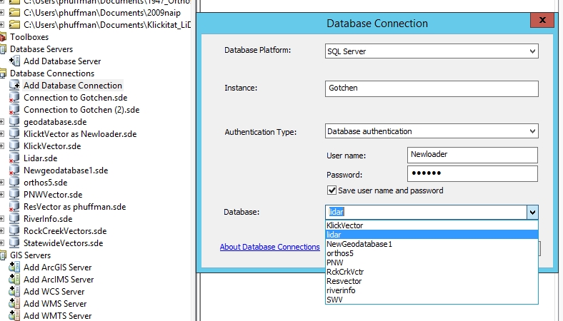
More on this. I completed the two step backup and restore process, got all my databases restored to the new SQL server. Add Database Connection was able to connect to all of them but one, the one with all my lidar data and products, the biggest one. Tried both operating system and database authentication. The database pulldown lists the lidar database, but the connection always fails, with "Failed to connect to the specified server".
- Mark as New
- Bookmark
- Subscribe
- Mute
- Subscribe to RSS Feed
- Permalink
Did you rename the database while restoring it?
- Mark as New
- Bookmark
- Subscribe
- Mute
- Subscribe to RSS Feed
- Permalink
It looks like the name on the old server is lidar09, while the name in the restored file list is lidar.
The other thing that is different about this geodatabase is that in the 9.3 version, it was one of the two that I somehow made the transactional version dbo.Default rather than the standard sde.Default.
I'm going to try to import the database features classes one by one from an SDE file connection. This seems to be moving, except I didn't find a way to create a new feature dataset on the new geodatabase.
- Mark as New
- Bookmark
- Subscribe
- Mute
- Subscribe to RSS Feed
- Permalink
You cannot restore a Geodatabase with a different name in SQL Server.
- Mark as New
- Bookmark
- Subscribe
- Mute
- Subscribe to RSS Feed
- Permalink
Although I was able to move a batch of Lidar data from my 9.3 SDE host over my network with the SDE file connection, feature datasets aren't coming across with right click imports or exports as intact feature datasets, just the feature classes within the feature datasets. So terrains will have to be recreated.
I've been trying to move the feature classes into new feature datasets on the 10.3.1 side, but having trouble getting the spatial references to match. This is strange. When I try to create a new feature dataset in the 10.3.1 enterprise goedatabase, there is no import button for the coordinate system to bring it in from one of the feature classes like I am used to, and like appears in the 10.3.1 help files, and this thread https://community.esri.com/message/77856#77856
- Mark as New
- Bookmark
- Subscribe
- Mute
- Subscribe to RSS Feed
- Permalink
You cannot transfer Feature Datasets from one gdb to another using the 'Feature Class to Feature Class' tool. As you observed, only the feature classes will be transferred.
You will either have to use Copy\Paste or Exmport\Import XML Workspace Document tool for the Feature Datasets.
- Mark as New
- Bookmark
- Subscribe
- Mute
- Subscribe to RSS Feed
- Permalink
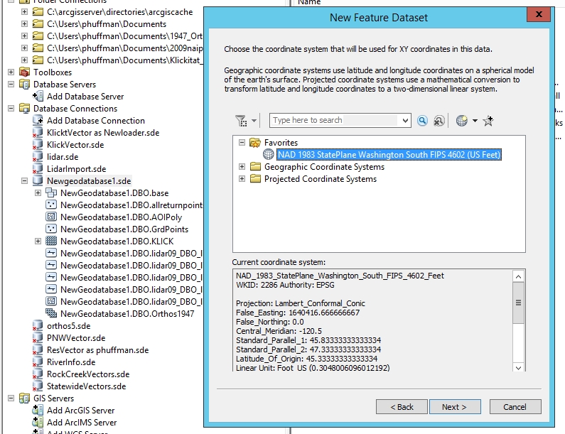
Trying now to create new feature datasets to replace the terrain feature datasets on my 9.3 server. However, when I right click in 10.3.1 ArcCatalog or ArcMap Catalog Window > New > Feature Dataset, after naming the new feature dataset, the next window wants me to define the xy coordinate system. In my experience, and in the 10.3.1 and 10.2.2 help files, there is supposed to be an Import button on this window that allows me to get the coordinate system from an existing feature class. (as in the link above to another thread) I don't understand why it seems to be missing in both 10.3.1 enterprise geodatabases and with 10.2.2 file geodatabases. (see above image) Is there an option in Desktop that I need to set?
I've tried to set the xy and z coordinate systems of a new feature dataset carefully to match the feature classes that are going into it, but I still get a "the spatial references do not match" message when I try to move a feature class into the new feature dataset.
The Create Feature Dataset (Data Management) tool looks like it still has the option of getting spatial reference "
- By referencing a feature class or feature dataset whose spatial reference you want to apply, such as C:/workspace/myproject.gdb/landuse/grassland. " so I could try this in a python window.
If this gets any more tricky, I'll have to go bug my DBA to backtrack and see if he can figure out where he changed the database name in the two step restore process
- Mark as New
- Bookmark
- Subscribe
- Mute
- Subscribe to RSS Feed
- Permalink
When I tried copy/paste in 10.3.1 ArcCatalog, the paste failed with "Failed to paste lidar09.DBO.LD2011SwaleGrnd The application is not licensed to create or modify schema for this type of data"
- Mark as New
- Bookmark
- Subscribe
- Mute
- Subscribe to RSS Feed
- Permalink
I wonder why Import XML Workspace Document tool gave me a crash of Desktop 10.3.1 to the "Serious Problem. Tell ESRI what you were doing" window. I'll try exporting just a feature dataset to xml next.