- Home
- :
- All Communities
- :
- Products
- :
- ArcGIS Enterprise
- :
- ArcGIS Enterprise Questions
- :
- Re: Map Cache Checkerboard
- Subscribe to RSS Feed
- Mark Topic as New
- Mark Topic as Read
- Float this Topic for Current User
- Bookmark
- Subscribe
- Mute
- Printer Friendly Page
Map Cache Checkerboard
- Mark as New
- Bookmark
- Subscribe
- Mute
- Subscribe to RSS Feed
- Permalink
All,
i was wondering if anyone else has experienced the following issue while zooming in on their cached map service...
while zooming through levels 0-17 all the imagery appears fine, the next step down to level 18 the imagery changes to the black/white checkerboard pattern but you can still see the GIS data (addresses, roads, etc), zoom to level 19 and the imagery comes back into view.
levels 0-18 have successfully cached all tiles according to the status.gdb (i even rebuilt the status thinking it was wrong, it wasnt). level 19 is still in the caching process.
desktop vesrion 10.5.1
server version 10.5.1
thanks for the help!
Dave
- Mark as New
- Bookmark
- Subscribe
- Mute
- Subscribe to RSS Feed
- Permalink
1.) Make sure users have READ access to imagery.
2.) Be sure to maintain same path to imagery as the one you used during geoprocessing.
For example:
O:\imagery\orthos
\\MachineName\imagery\orthos
Add a connection to imagery folder in ArcCatalog or Catalog pane in ArcGIS Pro.
- Mark as New
- Bookmark
- Subscribe
- Mute
- Subscribe to RSS Feed
- Permalink
1) check - that was my first thought and everything looks good
2) so originally with the service was published and cache was the path for the imagery was the local drive, ie: c:\imagery\tiles
a. i later adjusted this to a UNC path name and republished the service keeping the existing cache
3) this environment was running 10.2.2 and was upgrade to 10.5.1
a. could this upgrade has cause some issues with rebuilding certain parts of the cache?
i have never only seen one level not sure, its usually been an all or nothing in my experience.
Dave
- Mark as New
- Bookmark
- Subscribe
- Mute
- Subscribe to RSS Feed
- Permalink
as a test...
1) open mxd in arcgis and using the area of interest recreate all tiles within a given area easy to find
2) after creating all tiles in a certain area i zoomed to the area from the REST end point and level 18 was now visible ONLY in the are of interest that i had just rebuilt.
thoughts?
- Mark as New
- Bookmark
- Subscribe
- Mute
- Subscribe to RSS Feed
- Permalink
Take it from the top and reprocess the whole thing. The mosaic stores the processed images at the other levels once you zoom in close enough it calls directly to the actual image.
I think that some thing got messed up in the processing. When I do this geoprocessing segregate out every process.

- Mark as New
- Bookmark
- Subscribe
- Mute
- Subscribe to RSS Feed
- Permalink
John,
thanks for the input!
in the back of my mind, I was thinking I would have to rebuild (285gb worth of cache on our machine = 1 week of work) my relationship with the mosaic process is a love/hate...its frustrating that you have to wait so long to see if anything is wrong!
may I ask what led you to separating the process as you do?
dave
- Mark as New
- Bookmark
- Subscribe
- Mute
- Subscribe to RSS Feed
- Permalink
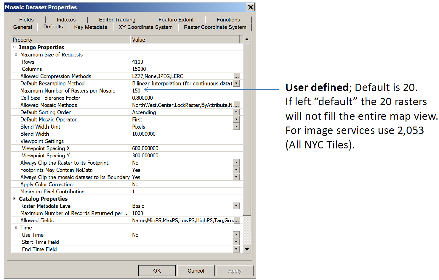
I tried to run it all in one geoprocess. Never could get it to work. I single out each step and I get one process to complete before the next process comences. Did you check settings? Worth a look here.
One more thing, I never build these Mosaics in one attempt. It usually takes a few attempts to get it optimized and the way you want it.