- Home
- :
- All Communities
- :
- Products
- :
- ArcGIS Enterprise
- :
- ArcGIS Enterprise Questions
- :
- Deploying clip and ship in an arcGIS online web ma...
- Subscribe to RSS Feed
- Mark Topic as New
- Mark Topic as Read
- Float this Topic for Current User
- Bookmark
- Subscribe
- Mute
- Printer Friendly Page
Deploying clip and ship in an arcGIS online web map as a geoprocessing task
- Mark as New
- Bookmark
- Subscribe
- Mute
- Subscribe to RSS Feed
- Permalink
- Report Inappropriate Content
I followed this tutorial to the letter: Geoprocessing service example: Clip And Ship—Documentation (10.3 and 10.3.1) | ArcGIS for Server
I want users to be able to view data in a web map, select an area and clip a series of rasters and download the result. Seems like something which should be easy to do but it most certainly isn't!
Everything looks good in both the web map interface and arcCatalog on the server in terms of seeing the geoprocessing service, selecting parameters and so on.
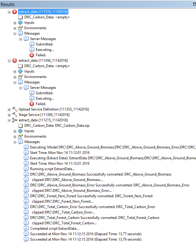
I can run the geoprocessing on the image services from arcCatalog. But when I try and run the geoprocessing task when it is on the server in both the web app builder interface and arcCatalog I get a wonderfully helpful : Submitted...Executing..Failed.
I have uploaded all the raster layers as image services. I have tried them as mosaic first, as raster, as a map service - nothing works. All the data are accessible and viewable on the server via arcCatalog and arcGIS online.
This is my geoprocessing service: http://panda.maps.arcgis.com/home/item.html?id=3e46ad8e51e247869a6a7821f889f9cd
This is one of the layers I want to be able to clip and ship: http://panda.maps.arcgis.com/home/item.html?id=fea5d6edbc0646fea33e5034c51c8111
I wanted to download the python code from ESRI but their link doesn't work: Clip, Zip and Ship your image service, using Python | ArcGIS Blog
Anyone know what I am doing wrong?
many thanks!
aurélie