- Home
- :
- All Communities
- :
- Products
- :
- ArcGIS Enterprise
- :
- ArcGIS Enterprise Questions
- :
- Re: ArcGIS Server Properties Dialog
- Subscribe to RSS Feed
- Mark Topic as New
- Mark Topic as Read
- Float this Topic for Current User
- Bookmark
- Subscribe
- Mute
- Printer Friendly Page
- Mark as New
- Bookmark
- Subscribe
- Mute
- Subscribe to RSS Feed
- Permalink
All
Once you publish a service to your arcgis server and you right click it within the catalog window in arcmap...
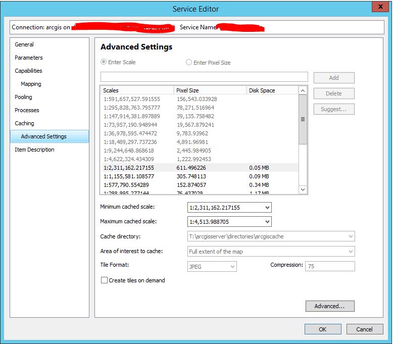
there is an option called "Service Properties" - please see the screenshots attached.
I was wondering if this is a "live" reflection of the settings of the service that is published to server?
If so, there is a huge disconnect between what is actually been cached and what this UI is tell the user is cached and available.
thanks
Dave
Solved! Go to Solution.
Accepted Solutions
- Mark as New
- Bookmark
- Subscribe
- Mute
- Subscribe to RSS Feed
- Permalink
It looks like the service configuration file on disk is updated:
Ex.
C:\arcgisserver\config-store\services\SampleWorldCities.MapServer\SampleWorldCities.MapServer.json
Under the "properties" key, the minScale and maxScale will be updated:
"properties": {
...
"minScale": "250000000",
...
"maxScale": "640000000",
...
}
If this is supposed to be automated, what I would do is edit the setting in Manager and then monitor the requests. It edits the service through the Admin API, which returns a jobID which can be used to check the status of the job. Once it completes, all UI's should honor the correct cache levels.
I'm not sure how it would have gotten out of sync though. Do you see this for every service? Is this a recently upgraded environment? Not sure what the catalyst would have been.
- Mark as New
- Bookmark
- Subscribe
- Mute
- Subscribe to RSS Feed
- Permalink
What is the disconnect? Did you cache at different scales than what the UI is showing? Is the disk space usage off?
That UI should be making a request to the service information through the Admin API. The Admin API retrieves the results from the service configuration files on disk, so the files on disk would be incorrect as well.
- Mark as New
- Bookmark
- Subscribe
- Mute
- Subscribe to RSS Feed
- Permalink
We have published a service that all levels have a cache (0-19)
for some reason, that dialog window is only showing us that there are levels (7-17) available. this is also the case with the "manage map server cache tiles" tool dialog.
im not sure why we have levels 0-19 cached but everything with ESRI is telling us we only have levels 7-17.
thanks
dave
- Mark as New
- Bookmark
- Subscribe
- Mute
- Subscribe to RSS Feed
- Permalink
What does it show at REST? Does it show all expected levels? Can you drag the slider to cover all scales?
- Mark as New
- Bookmark
- Subscribe
- Mute
- Subscribe to RSS Feed
- Permalink
yes the REST shows all levels, and yes, we can move the slider which then allows all levels to be accessed.
we are automating the process (manually moving sliders is not an option), which has worked for a very long time and now all of a sudden were having problems. back to my original question...Are the following UIs within arcmap intended to be a true representation of what is published to server:
which files would fall under "service configuration files on disk"?
thanks
dave
- Mark as New
- Bookmark
- Subscribe
- Mute
- Subscribe to RSS Feed
- Permalink
It looks like the service configuration file on disk is updated:
Ex.
C:\arcgisserver\config-store\services\SampleWorldCities.MapServer\SampleWorldCities.MapServer.json
Under the "properties" key, the minScale and maxScale will be updated:
"properties": {
...
"minScale": "250000000",
...
"maxScale": "640000000",
...
}
If this is supposed to be automated, what I would do is edit the setting in Manager and then monitor the requests. It edits the service through the Admin API, which returns a jobID which can be used to check the status of the job. Once it completes, all UI's should honor the correct cache levels.
I'm not sure how it would have gotten out of sync though. Do you see this for every service? Is this a recently upgraded environment? Not sure what the catalyst would have been.
- Mark as New
- Bookmark
- Subscribe
- Mute
- Subscribe to RSS Feed
- Permalink
sorry for the delay in response...
you were right!
we went in and looked at those json files and noticed that they were out of since with the min/max levels. so we adjusted our python scripts to actually define those levels and we now have all layers!
thanks for the help.
dave