- Home
- :
- All Communities
- :
- Products
- :
- ArcGIS Enterprise
- :
- ArcGIS Enterprise Questions
- :
- Re: ArcGIS Server: Geodatabase error: Only one spa...
- Subscribe to RSS Feed
- Mark Topic as New
- Mark Topic as Read
- Float this Topic for Current User
- Bookmark
- Subscribe
- Mute
- Printer Friendly Page
ArcGIS Server: Geodatabase error: Only one spatial column is supported in this operation
- Mark as New
- Bookmark
- Subscribe
- Mute
- Subscribe to RSS Feed
- Permalink
- Report Inappropriate Content
I have a layer, water_pipe. I am creating a feature layer in the arcgis javascript api, and when the feature layer loads, it give the error "cannot execute query" in the network logs.
The query string parameters look like this:
- f:json
- returnGeometry:true
- spatialRel:esriSpatialRelIntersects
- maxAllowableOffset:1
- geometry:{"xmin":-10384451.501584552,"ymin":5510511.210446009,"xmax":-10383876.812244719,"ymax":5511085.899785845,"spatialReference":{"wkid":102100,"latestWkid":3857}}
- geometryType:esriGeometryEnvelope
- inSR:102100
- outFields:*
- outSR:102100
- token:<token>
On the server logs, the above error message is given.
Geodatabase error: Only one spatial column is supported in this operation [gis.DBO.water_pipe][STATE_ID = 1447].
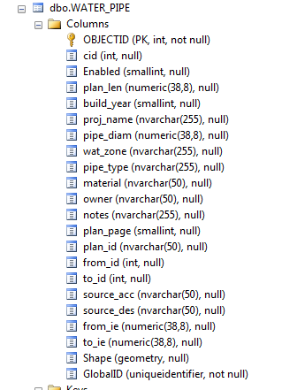
There is only one Shape column, here is a screenshot from the sql server manager:
Any suggestions on what I can do to fix this?
Solved! Go to Solution.
- Mark as New
- Bookmark
- Subscribe
- Mute
- Subscribe to RSS Feed
- Permalink
- Report Inappropriate Content
So Gregg your water_pipe and san_pipe layer both had the Shape field before the newly added field when they were not working, unlike the storm_pipe layer that had the Shape field last so it always worked properly. Once you moved the Shape field to the last field in both the water_pipe and san_pipe layers, the problem was resolved in AGS 10.4.1. Would you say that is the correct summary of this problem?
Would you know if this same problem is occurring in AGS v10.5 that has now been released?
- Mark as New
- Bookmark
- Subscribe
- Mute
- Subscribe to RSS Feed
- Permalink
- Report Inappropriate Content
Yes, that is exactly what was the issue. I haven't been able to test this on version 10.5 yet though.
- Mark as New
- Bookmark
- Subscribe
- Mute
- Subscribe to RSS Feed
- Permalink
- Report Inappropriate Content
I can confirm that this occurs in 10.5 though not dependably. I had two MapService layers that were doing this. For one, I was able to just move the Shape field to the end of the field list in the MXD and republish and it worked. For the second, this was not enough. I noticed that the only significant difference between the layer that was working correctly after the fix and the one that was not was that I had an alias on the OBJECTID field as ESRI ID. When I removed the alias and republished, it worked.
I also had another MapService layer that was not showing any of the fields after the Shape field (but was at least only showing the Shape field once). Once I moved the Shape field to the end of the field list in the MXD, all the fields showed up in the REST endpoint.
I have been a bit frustrated with the number of silly bugs like this in 10.5.
- « Previous
-
- 1
- 2
- Next »
- « Previous
-
- 1
- 2
- Next »