Turn on suggestions
Auto-suggest helps you quickly narrow down your search results by suggesting possible matches as you type.
Cancel
- Home
- :
- All Communities
- :
- Products
- :
- ArcGIS Enterprise
- :
- ArcGIS Enterprise Portal Questions
- :
- make coincident lines distinct for symbolization?
Options
- Subscribe to RSS Feed
- Mark Topic as New
- Mark Topic as Read
- Float this Topic for Current User
- Bookmark
- Subscribe
- Mute
- Printer Friendly Page
make coincident lines distinct for symbolization?
Subscribe
2563
3
11-13-2013 12:56 PM
11-13-2013
12:56 PM
- Mark as New
- Bookmark
- Subscribe
- Mute
- Subscribe to RSS Feed
- Permalink
- Report Inappropriate Content
Hi,
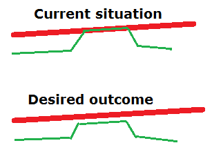
I am struggling to symbolize coincident lines. See the attached drawing, where I've used different line weights to indicate the problem.
The lines represent divided roadways, however both sides of the road were drawn almost exactly on top of each other. If they???re not perfectly coincident, then they???re still close enough that the symbols ???clash???.
I would like to ???shift??? one of the features sideways so the symbols are distinct. It doesn???t matter which line gets shifted or in which direction, but I would like for them to remain parallel. This issue is present for <100 features out of a set of 10,000+, and the data is changing frequently enough that it???s not feasible to manually adjust these.
Can anyone point me in the right direction so I can accomplish this, without resorting to different line weights? (what if the gr
Thanks!
3 Replies
11-13-2013
02:03 PM
- Mark as New
- Bookmark
- Subscribe
- Mute
- Subscribe to RSS Feed
- Permalink
- Report Inappropriate Content
A way to manage this is with Representations - see this:
What are representations?
Desktop » Mapping » Working with layers » Displaying layers
http://resources.arcgis.com/en/help/main/10.2/index.html#//00s50000004m000000
What are representations?
Desktop » Mapping » Working with layers » Displaying layers
http://resources.arcgis.com/en/help/main/10.2/index.html#//00s50000004m000000
11-14-2013
05:51 AM
- Mark as New
- Bookmark
- Subscribe
- Mute
- Subscribe to RSS Feed
- Permalink
- Report Inappropriate Content
Wayne_Whitley;344088 wrote:
A way to manage this is with Representations QUOTE]
Thanks Wayne. I'll read up on Representations and see what I can come up with.
It looks fairly complicated...will it be able to adapt to whatever symbolization I use in the future? Or am I locked into a particular symbolization scheme once I begin using Representations? This map is to support one of those projects where the symbolization (line weights, number of classes, etc) is constantly being re-specced...which is why I am not simply going into the featureclass and manually moving things around!
Thanks for the help.
11-14-2013
06:17 AM
- Mark as New
- Bookmark
- Subscribe
- Mute
- Subscribe to RSS Feed
- Permalink
- Report Inappropriate Content
The underlying data isn't changed, if that's what you're asking, although you are right it's fairly complex and not likely to be maintenance-free.
You may also check out 'symbol level drawing' - this may or may not work satisfactorily for you:
Displaying roads using symbol level drawing
Desktop » Mapping » Working with layers » Displaying layers
http://resources.arcgis.com/en/help/main/10.1/index.html#//00s500000014000000
You may also check out 'symbol level drawing' - this may or may not work satisfactorily for you:
Displaying roads using symbol level drawing
Desktop » Mapping » Working with layers » Displaying layers
http://resources.arcgis.com/en/help/main/10.1/index.html#//00s500000014000000