Turn on suggestions
Auto-suggest helps you quickly narrow down your search results by suggesting possible matches as you type.
Cancel
- Home
- :
- All Communities
- :
- Products
- :
- ArcGIS Enterprise
- :
- ArcGIS Enterprise Portal Questions
- :
- Label corners of map extent with X,Y or Lat/Lon co...
Options
- Subscribe to RSS Feed
- Mark Topic as New
- Mark Topic as Read
- Float this Topic for Current User
- Bookmark
- Subscribe
- Mute
- Printer Friendly Page
Label corners of map extent with X,Y or Lat/Lon coordinates
Subscribe
1690
0
03-18-2011 10:34 AM
03-18-2011
10:34 AM
- Mark as New
- Bookmark
- Subscribe
- Mute
- Subscribe to RSS Feed
- Permalink
- Report Inappropriate Content
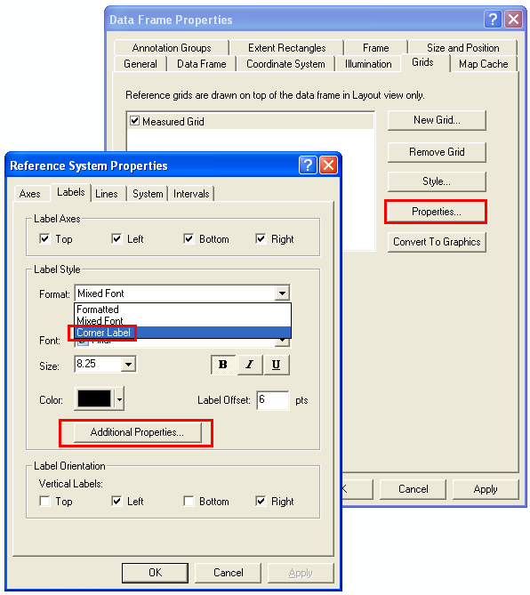
From the image below, you can label a maps corners based on an existing Measure Grid, but this label indicates not the corner position, but the grid line closest to that edge.
[ATTACH]5458[/ATTACH]
Using either a Measured Grid(in X,Y) or a Graticule (lat,lon / dd / dms) what are some of the options in ArcGIS 9 and above that would allow you to do this easily or automatically?
My current workflow:
Create extent polygon > Convert to points > Create two new x/y fields and calculate geometry > use those fields in a label expression > optional - copy and paste to graphic element
The question is also being asked on stackexchange: Labeling coordinate value at 4 corners of graticule in arcgis
0 Replies