Turn on suggestions
Auto-suggest helps you quickly narrow down your search results by suggesting possible matches as you type.
Cancel
- Home
- :
- All Communities
- :
- Products
- :
- ArcGIS Enterprise
- :
- ArcGIS Enterprise Portal Questions
- :
- Cartographic representation: Overriding lines
Options
- Subscribe to RSS Feed
- Mark Topic as New
- Mark Topic as Read
- Float this Topic for Current User
- Bookmark
- Subscribe
- Mute
- Printer Friendly Page
Cartographic representation: Overriding lines
Subscribe
1014
0
03-28-2012 06:22 PM
03-28-2012
06:22 PM
- Mark as New
- Bookmark
- Subscribe
- Mute
- Subscribe to RSS Feed
- Permalink
- Report Inappropriate Content
We are using ArcGIS/Info/Production Mapping 10 (quite new with all capabilities in representation).
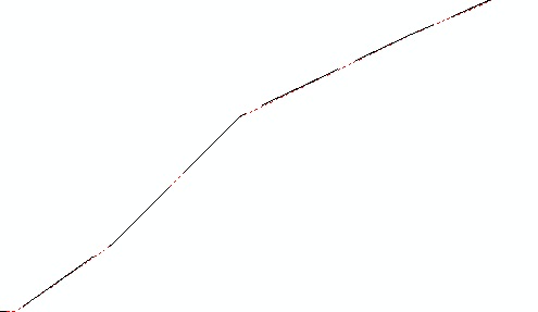
We are using polygons to represent land uses and then we have different kind
of line symbols representing roads, tracks etc. In our topographic maps we want to show the land use
lines as dots. The question is if there is a way to override one representation with another. Example. when we
have track overlaying the polygon line (land use with small dashed dots) we need to show only the track symbol
not mixed track and land use line. Picture as an attachment (quite poor example) shows two lines overlapping
when we should only see the track (tracks were used to create those polygons)
Thanks
Sami
[ATTACH=CONFIG]13091[/ATTACH]
0 Replies