Turn on suggestions
Auto-suggest helps you quickly narrow down your search results by suggesting possible matches as you type.
Cancel
- Home
- :
- All Communities
- :
- Products
- :
- ArcGIS Enterprise
- :
- ArcGIS Enterprise Portal Questions
- :
- Re: a problem about transformation for WGS84 to NA...
Options
- Subscribe to RSS Feed
- Mark Topic as New
- Mark Topic as Read
- Float this Topic for Current User
- Bookmark
- Subscribe
- Mute
- Printer Friendly Page
a problem about transformation for WGS84 to NAD83
Subscribe
2329
5
08-03-2011 03:20 AM
08-03-2011
03:20 AM
- Mark as New
- Bookmark
- Subscribe
- Mute
- Subscribe to RSS Feed
- Permalink
- Report Inappropriate Content
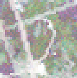
I got some tm images which has GCS_WGS_1984??and i want to reproject to NAD_1983 to fit the product of NLCD.i pick up the "project raster" tool and using NAD_1983_To_WGS_1984_5 which is suitable for North America area. But there had some pixels distortion which i attached at end.
Could someone help me about this problems and how to imply the correct transformation?
Thanks,
Xi
original wgs84

nad83 after transfer
Could someone help me about this problems and how to imply the correct transformation?
Thanks,
Xi
original wgs84
nad83 after transfer
5 Replies
08-10-2011
06:06 AM
- Mark as New
- Bookmark
- Subscribe
- Mute
- Subscribe to RSS Feed
- Permalink
- Report Inappropriate Content
My guess is that your raster is being rectified when it is being projected. I am assuming your WGS84 image was georeferenced but not georectified - this is typical for orthos from vendors. So when projecting to NAD83, Arc must georectify the image (Resampling Technique). The pixels are now all oriented north.
If this is the case, I unfortunately do not have any good solutions for you.
One not great idea would be to make the Output Cell Size to about half of what it is now and that would reduce the distortion but quadruple the storage space.
In the past I have had to request NAD83 world files for an ortho delivery from the vendor to avoid this rectification issue (and to save HDD space).
09-05-2011
02:39 AM
- Mark as New
- Bookmark
- Subscribe
- Mute
- Subscribe to RSS Feed
- Permalink
- Report Inappropriate Content
Jim
thank you very much and i'm sorry for replying so late!
my images are landsat tm5 which are free provided at USGS's website,i am not sure whether the they were georectified.
i will try your method to half the cells and find whether it have a acceptable result.
thank you~
thank you very much and i'm sorry for replying so late!
my images are landsat tm5 which are free provided at USGS's website,i am not sure whether the they were georectified.
i will try your method to half the cells and find whether it have a acceptable result.
thank you~
09-05-2011
06:29 PM
- Mark as New
- Bookmark
- Subscribe
- Mute
- Subscribe to RSS Feed
- Permalink
- Report Inappropriate Content
I'm sorry, I should have posted about this earlier. Make sure the tool (or geoprocessing settings) is using nearest neighbor.
And, more importantly, the cell size is 30m. The difference between WGS84 and NAD83 in the contiguous US (48 states) is about a meter. I wouldn't bother reprojecting the raster. Use its property page in ArcCatalog or the Define Projection tool to set it to NAD83.
Melita
And, more importantly, the cell size is 30m. The difference between WGS84 and NAD83 in the contiguous US (48 states) is about a meter. I wouldn't bother reprojecting the raster. Use its property page in ArcCatalog or the Define Projection tool to set it to NAD83.
Melita
09-06-2011
03:29 AM
- Mark as New
- Bookmark
- Subscribe
- Mute
- Subscribe to RSS Feed
- Permalink
- Report Inappropriate Content
thank you very much, Melita
actually, i found the problem is caused by that i choose the nearest neighbor reampling method instead of binary method which can product nice result.
i will use your way in the future, thanks
Xi
actually, i found the problem is caused by that i choose the nearest neighbor reampling method instead of binary method which can product nice result.
i will use your way in the future, thanks
Xi
09-06-2011
07:16 AM
- Mark as New
- Bookmark
- Subscribe
- Mute
- Subscribe to RSS Feed
- Permalink
- Report Inappropriate Content
Oops, I had the resampling methods backwards! Thanks for correcting me, and I'm glad that you solved your problem.
Melita
Melita