Turn on suggestions
Auto-suggest helps you quickly narrow down your search results by suggesting possible matches as you type.
Cancel
- Home
- :
- All Communities
- :
- User Groups
- :
- ArcGIS Desktop Deutschland
- :
- Questions
- :
- reproject coordinate system
Options
- Subscribe to RSS Feed
- Mark Topic as New
- Mark Topic as Read
- Float this Topic for Current User
- Bookmark
- Subscribe
- Mute
- Printer Friendly Page
reproject coordinate system
Subscribe
1286
1
07-04-2019 05:44 AM
07-04-2019
05:44 AM
- Mark as New
- Bookmark
- Subscribe
- Mute
- Subscribe to RSS Feed
- Permalink
When I reproject a raster image using ArcGSi 10.6. ArcToolbox ArcGIS always suggests and loads a specific transformation method which is not the one I want to use. Why does ArcGIS autosuggest and load a specific method and how can I stop it?
1 Reply
07-04-2019
06:42 AM
- Mark as New
- Bookmark
- Subscribe
- Mute
- Subscribe to RSS Feed
- Permalink
- Open your MXD and navigate to View > Data Frame Properties, go to the Coordinate system Tab and click the Transformations button.
- This dialog will have a list of all the coordinate systems for the data being used in the map. Note, you need to have your Data Frame coordinate system set for the MXD and data added to your MXD in the systems you want to transform between to initially configure this dialog.
- in the "Convert from" selection dialog, select the coordinate system you would like to assign a fixed transformation to.
- The "Into" selection dialog will be set to the data frame coordinate system
- In the "Using" selection dialog select the transformation you want to use between these two systems.
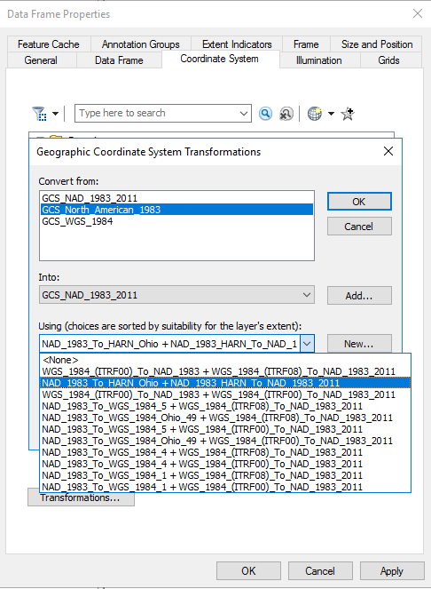
- The screen shot above shows an example from our system as we always want to use the NAD_1983_To_HARN_Ohio + NAD_1983_HARN_To_NAD_1983_2011 transformation between GCS_NAD_1983 and GCS_NAD_1983_2011 for our data.
- Click OK then click Apply
- Save your MXD
- This will now apply the NAD_1983_To_HARN_Ohio + NAD_1983_HARN_To_NAD_1983_2011 transformation between GCS_NAD_1983 and GCS_NAD_1983_2011 anytime data is added to this MXD in GCS_NAD_1983