- Home
- :
- All Communities
- :
- Products
- :
- ArcGIS Collector
- :
- ArcGIS Collector Questions
- :
- Is it possible to collect accurate Z coordinate va...
- Subscribe to RSS Feed
- Mark Topic as New
- Mark Topic as Read
- Float this Topic for Current User
- Bookmark
- Subscribe
- Mute
- Printer Friendly Page
Is it possible to collect accurate Z coordinate values with Collector and Trimble R2?
- Mark as New
- Bookmark
- Subscribe
- Mute
- Subscribe to RSS Feed
- Permalink
- Report Inappropriate Content
We have been told that the ESRI software does not calculate the correction from HAE to MSL. We have also been told that people are, indeed, using this equipment configuration to do so. And it seems like it should be poosible.
- Mark as New
- Bookmark
- Subscribe
- Mute
- Subscribe to RSS Feed
- Permalink
- Report Inappropriate Content
The workarounds that other users have posted here to transform from Height Above Ellipsoid to MSL elevations are appreciated, but it would really be nice if ESRI could include these transformations as a native part of Collector for ArcGIS functionality. MSL elevations are the industry standard, and Height Above Ellipsoid is almost useless unless you just need to compare relative elevation differences.
- Mark as New
- Bookmark
- Subscribe
- Mute
- Subscribe to RSS Feed
- Permalink
- Report Inappropriate Content
Vertical transformations are still very much in our future plans for Collector. Although I cannot give you a specific date, we hope to have this in some form within the year.
Regards,
Colin
Colin
- Mark as New
- Bookmark
- Subscribe
- Mute
- Subscribe to RSS Feed
- Permalink
- Report Inappropriate Content
Is this still the case? Will this be part of the launch of Field Maps?
- Mark as New
- Bookmark
- Subscribe
- Mute
- Subscribe to RSS Feed
- Permalink
- Report Inappropriate Content
Ross Volkwein This is still on the roadmap, but will not be a part of the initial release of Field Maps later this month.
Regards,
Colin
Colin
- Mark as New
- Bookmark
- Subscribe
- Mute
- Subscribe to RSS Feed
- Permalink
- Report Inappropriate Content
Has ESRI made any progress with this issue (using Collector and a centimeter R2 antenna to collect accurate Z coordinate data)? Without scientific workarounds? When I first asked this question I was told that some progress may be coming soon.
- Mark as New
- Bookmark
- Subscribe
- Mute
- Subscribe to RSS Feed
- Permalink
- Report Inappropriate Content
Has anyone had an error message "Unable to locate the attachment table for the input feature class" using the projectZ tool? The tool moves through several steps, but fails while running the maintain attachments script. After having issues with it, I disabled attachments on the AGO feature class but that didn't fix it.
I am adding the feature class to Pro, exporting it to a local GDB, and running the tool on that exported feature class using the guidelines from Lance Cole (thanks, by the way!). The only difference being that my data is in ITRF 2008.
I have also tried exporting it to a shapefile and deleting all but the essential fields to narrow down the issue, but it always fails on the maintain attachment step. I also tried turning off "maintain attachments" in the environments setting for projectZ.
Any help would be appreciated! I attached a screenshot of the error message.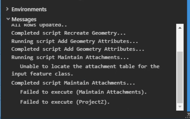
- Mark as New
- Bookmark
- Subscribe
- Mute
- Subscribe to RSS Feed
- Permalink
- Report Inappropriate Content
Any update from ESRI on if Field Maps has been updated to deal with vertical transformations?
- Mark as New
- Bookmark
- Subscribe
- Mute
- Subscribe to RSS Feed
- Permalink
- Report Inappropriate Content
Im using a Trimble DA2 Catalyst with Field Maps to collect survey data, and vertical accuracy is very important for our work. When we collect points in the field we are able to see the Ortho height measurements, but they do not get recorded to the attribute field. I ran through the Project Z process posted in this thread, but I am not able to get the elevations to match what was shown in the pop up in field maps. I have ensured my coordinate systems are all correct and have ran through the process several times but am still unable to get the right numbers. For example, the ortho height (m) shown below is 285.62, but when I run the Project Z tool I get 285.60. Is there any way to get more accurate results?

- « Previous
-
- 1
- 2
- Next »
- « Previous
-
- 1
- 2
- Next »