- Home
- :
- All Communities
- :
- Products
- :
- ArcGIS CityEngine
- :
- ArcGIS CityEngine Questions
- :
- Terrain import clipping?
- Subscribe to RSS Feed
- Mark Topic as New
- Mark Topic as Read
- Float this Topic for Current User
- Bookmark
- Subscribe
- Mute
- Printer Friendly Page
Terrain import clipping?
- Mark as New
- Bookmark
- Subscribe
- Mute
- Subscribe to RSS Feed
- Permalink
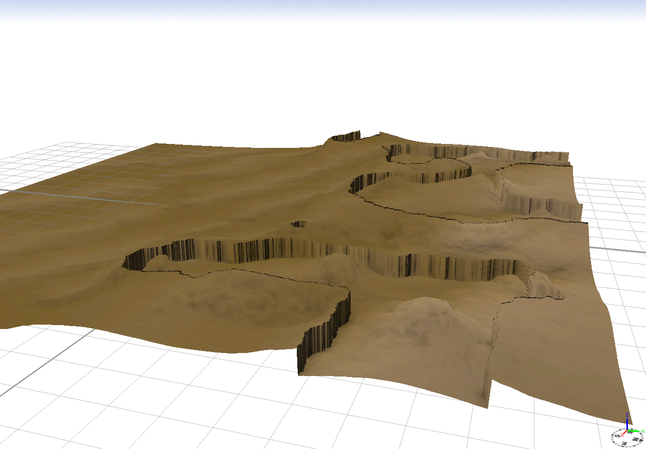
Why do all of my height map imports for the Terrain Layer come out looking like this? The higher elevations all get "clipped" down.
- Mark as New
- Bookmark
- Subscribe
- Mute
- Subscribe to RSS Feed
- Permalink
Hello Drew,
can you please provide additional information on the DEM regarding:
- image format (tiff,png,..)
- bit depth (8,16,32)
- number of channels (grey-scale (1), RGB (3), RGB + transparency (4))
- Mark as New
- Bookmark
- Subscribe
- Mute
- Subscribe to RSS Feed
- Permalink
Thomas, thanks for the reply.
It's not a DEM file, the height map was created using World Creator. The file itself is a 16-bit TIF (4096px x 4096px) with 1 channel (grey). Hope this helps.
- Mark as New
- Bookmark
- Subscribe
- Mute
- Subscribe to RSS Feed
- Permalink
Drew, thank you for the reply.
My tests with World Creator have shown, that it may help to convert the 16bit Tiff from grey-scale to RGB.
 For data with 16bit per channel, an image tool that can handle this bit depth is required. If there is no 16bit editing support, most of the tools will downsample the data to 8bit on import.
- Mark as New
- Bookmark
- Subscribe
- Mute
- Subscribe to RSS Feed
- Permalink
(sorry for the delay, I was out last week)
This worked, thank you. converting the TIF to RGB and the terrain imports fine into CityEngine.
- Mark as New
- Bookmark
- Subscribe
- Mute
- Subscribe to RSS Feed
- Permalink
Hi drew,
Try this, it might help you.
http://www.arcgis.com/home/item.html?id=298dba18a9494abc9da1342f59aa456e
- Mark as New
- Bookmark
- Subscribe
- Mute
- Subscribe to RSS Feed
- Permalink
It doesn't but thanks. It's not that the values are inverted, its that CityEngine shows the terrain data correctly up to a certain height, then it drops everything down to zero (presumably) and then continues to build the terrain correctly from there (as shown in my original image). It's as if it can read everything fine to a point, then "resets" the values.