- Home
- :
- All Communities
- :
- Products
- :
- ArcGIS CityEngine
- :
- ArcGIS CityEngine Questions
- :
- Re: Lat/Long in Web Scene
- Subscribe to RSS Feed
- Mark Topic as New
- Mark Topic as Read
- Float this Topic for Current User
- Bookmark
- Subscribe
- Mute
- Printer Friendly Page
Lat/Long in Web Scene
- Mark as New
- Bookmark
- Subscribe
- Mute
- Subscribe to RSS Feed
- Permalink
Hello,
I am looking for a way to fetch the latitude longitude of a point through the web scene just like in city engine. Now, I know the extent of the scene in Lat/Long and the extent of the scene in the scene coordinate system (Cartesian). One way is to interpolate/extrapolate between the two using the extents, but this is a bit complicated. Is there a way to directly get the Lat/Long value of a point in the web scene? Or an easier way to do this? any suggestions are helpful.
Thanks,
Somil Miglani
- Mark as New
- Bookmark
- Subscribe
- Mute
- Subscribe to RSS Feed
- Permalink
Hi,
No, bad news, this is not possible with the WebViewer at this point in time.
As the name implies, it's a viewer of 3d geometries, so the actual georeferencing data is not needed for this, thus dropped to save resources.
Ok ?
Matt
- Mark as New
- Bookmark
- Subscribe
- Mute
- Subscribe to RSS Feed
- Permalink
Hello Matthias,
Thanks for the reply. Too bad.
Okay!
Somil
- Mark as New
- Bookmark
- Subscribe
- Mute
- Subscribe to RSS Feed
- Permalink
Is it possible to get the lat/long of a scene inside CE? (not in the web scene)
I need to know the lat/long of the corners of the Terrain
I see the x and z offsets, but i have no idea how to convert them to lat/long.
Thanks
- Mark as New
- Bookmark
- Subscribe
- Mute
- Subscribe to RSS Feed
- Permalink
Hello Alexandro Vasile
The corners of the terrain are given in the projected scene coordinate system you have set in the your CityEngine scene.
CE help on: Scene Coordinate System
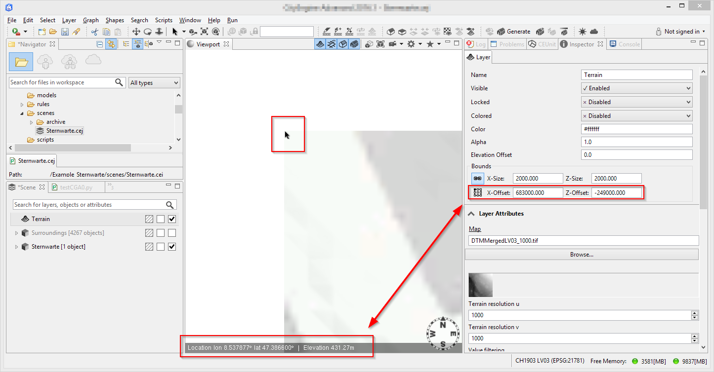
A quick way to show lat/long coordinates of the Terrain corner would be:
- Set the View Coordinate System to Long/Lat [decimal degrees]
- Set the camera to top
- Zoom into the corner of the terrain that correspondents to the x and z offset point
- Write down the displayed lat/long values
- Mark as New
- Bookmark
- Subscribe
- Mute
- Subscribe to RSS Feed
- Permalink
Hi Thomas,
Thank you very much for the response 
This is very helpful (really what i needed). But I still don't get the relation between the lat/long and the x/z-offsets.
Also, is there a way to extract them (not writing them down manually)? I found the python function getPosition, but it returns the x,y,z.
Thanks and have an amazing day
- Mark as New
- Bookmark
- Subscribe
- Mute
- Subscribe to RSS Feed
- Permalink
Last time I tried to get the coordinates (of building polygons) in lat/long I ended up writing my own coordinate transformation in Python. The formulas depend on the current and target coordinate system, but you should be able to google up the right formulas. A little warning, it's not going to be as simple as x2 =x1*2+20  .
.
- Mark as New
- Bookmark
- Subscribe
- Mute
- Subscribe to RSS Feed
- Permalink
In that case, I'll stick to writing it manually
thanks