- Home
- :
- All Communities
- :
- Products
- :
- ArcGIS CityEngine
- :
- ArcGIS CityEngine Questions
- :
- Re: Extracting Data from Viewshed Analysis
- Subscribe to RSS Feed
- Mark Topic as New
- Mark Topic as Read
- Float this Topic for Current User
- Bookmark
- Subscribe
- Mute
- Printer Friendly Page
Extracting Data from Viewshed Analysis
- Mark as New
- Bookmark
- Subscribe
- Mute
- Subscribe to RSS Feed
- Permalink
- Report Inappropriate Content
Hello!
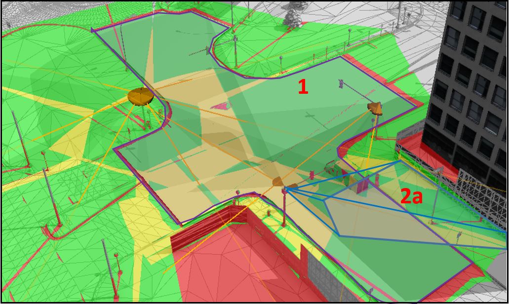
I've been working with City Engine over the past several months to learn how it might be used for a very specific application. I am working on finding a method for developing a "visibility map" of a road surface from several cameras within a scene. The Interactive Analysis Viewshed tool is very close to doing this, because it shows the "cumulative visibility" (as I'm calling it) of all the cameras within the scene. For instance, it shows which areas are covered once by a camera network (green), which areas are covered by 1+ cameras (yellow), and what areas are not visible to any cameras (red). I've included a sample image below of the Viewshed tool with several cameras in the scene.
1) My problem is that I cannot use the camera coverage data quite as I would like to be able to use it. I would like to export the camera coverage of the road surface (could be a flattened, simplified version of a road surface) as something like a DEM (with camera coverage data included).
2) Another possibility might be to export the percent coverage of a specific road surface "polygon" for a given set of cameras. The Viewshed "Visibility by Layer" tool seems able to do this for a single camera, but not for all the combined cameras within a scene. This might be more simple than the idea outlined in "1)" above because the output would just be the percent coverage instead of some sort of layer file (as specified in "1)" above).
Please let me know if you have any thoughts regarding this issue. I thank you for any recommendations you might have.
Thank you,
Chris C
- Mark as New
- Bookmark
- Subscribe
- Mute
- Subscribe to RSS Feed
- Permalink
- Report Inappropriate Content
Hi Christopher
Thanks for your question. There is no export functionality for the colorization. The only thing that I can think of atm is extracting it by doing screenshots of a top view.
- Mark as New
- Bookmark
- Subscribe
- Mute
- Subscribe to RSS Feed
- Permalink
- Report Inappropriate Content
Hi Christian,
Thank you for your response. This is an idea I had not thought of - taking an over head snapshot of the area of interest. It might prove difficult to extract information like percent coverage, however. I am thinking I would have to import this snapshot image into Arc Pro, crop it to the extent of the area of interest, and then hand-draw a polygon layer that corresponds to the extent of each visibility "color". I could then estimate percent coverage from the area of the polygons and the total area of the area of interest. This would definitely be a time consuming method to generate the desired output.
Another thought that just popped into my head might be, as you said, taking an overhead snapshot of the area interest with the viewshed colorization. Maybe I could then crop/clip this snapshot to the extent of the area of interest and then analyze this area of interest in some sort of photo editing software to estimate the percent coverage of each color? I'm imagining using Photoshop, Image Composite Editor.... or something similar, and the output would be "green = 75%, yellow = 15%, red = 10%"...
Do you think this sounds feasible?
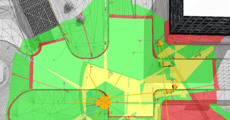
EDIT: One issue I see when looking from above is that the darker yellow of the viewshed view direction line is partly obscuring the area of interest. The darker yellow of the camera itself is also partially obscuring the view. Building shadows also appear to be adding additional color shades to the viewshed analysis which could pose a problem for this analysis. Please see attached image Capture4.jpg.
Thank you,
Chris C
- Mark as New
- Bookmark
- Subscribe
- Mute
- Subscribe to RSS Feed
- Permalink
- Report Inappropriate Content
Hi Christian,
I found this neat tool within the software TerraExplorer. It creates an exportable point cloud file representing the coverage of overlapping camera field of views, which would work for what I am doing. Any chance that this could be emulated in City Engine?
Skyline TerraExplorer v6.5 3D Viewshed, Viewshed Query and Snapshot Comparison - YouTube
Thanks,
Chris C
- Mark as New
- Bookmark
- Subscribe
- Mute
- Subscribe to RSS Feed
- Permalink
- Report Inappropriate Content
Anyone have any thoughts on this?
Thanks,
Chris
- Mark as New
- Bookmark
- Subscribe
- Mute
- Subscribe to RSS Feed
- Permalink
- Report Inappropriate Content
Are there other thoughts regarding how this might be done? Might there be some way to do this with python scripts referencing the Interactive Viewshed Analysis tool within City Engine?
Thank you,
Chris C
- Mark as New
- Bookmark
- Subscribe
- Mute
- Subscribe to RSS Feed
- Permalink
- Report Inappropriate Content
Just wanted to follow up to see if you found an answer to this?
I'm also trying to export the information from each viewshed (heading, tilt angle, field of view, etc.) to a table so that I can put them into an attribute table in ArcPro to run further analysis.
I do realize that you can convert viewsheds to features within the exploratory 3d analysis in Pro, but they still don't seem to let you have more than 4-5 viewsheds at once and I'm working with several dozen at a time where the overlap is necessary to know.
Thanks!
- Mark as New
- Bookmark
- Subscribe
- Mute
- Subscribe to RSS Feed
- Permalink
- Report Inappropriate Content
Hi, do you mean export viewshed attributes (tilt, field of etc.) from cityengine to ArcPro? If yes, how?
- Mark as New
- Bookmark
- Subscribe
- Mute
- Subscribe to RSS Feed
- Permalink
- Report Inappropriate Content
I would try to analyse it in Photoshop or similar. You can turn off shadows to remove unwanted shades in the screenshot.